Search This Blog

Friday, January 30, 2015

Custer to Buffalo Gap

For me, this is the best of the best.  This is where I most love to ride.  In about 33 miles, these remote roads wind up and down through granite spiked, conifer stuffed hills, roll down creek filled valleys, climb a final ridge line for a stunning vista and drop to the prairie below.  All along is history, wildlife, folk culture and more.  I had to include it the Black Hills BackBone.

I know there's nice stuff further west, from Jewell Cave to Pringle to Edgemont.  But that's for others, or for another day.  I'm going from Custer to Buffalo Gap.

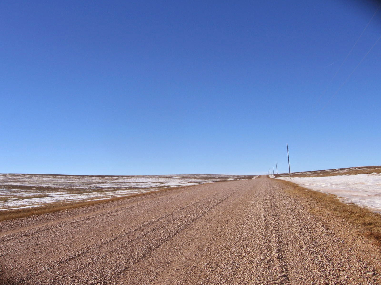
Emerging from the Black Hills to set sail for the prairie.
From Harbach Park in Custer, ride one block north on 6th Street and turn East (right) on U.S. Highway 16.  One mile later, turn South (right) on Sidney Park Road (793) for four miles of generally uphill riding through suburban Custer.  Turn East (left) on Flynn Creek Road (336) to return to forest gravel and the now familiar mostly up, sometimes down, spin through the hard rocks and thick trees of the central Black Hills.  Enjoy this stretch, as this terrain and these roads are winding down.

Rolling through the last of the granite and pines.
After about 9 miles, Flynn Creek Road (336) t-bones into Rankin Ridge Road (391).  Before turning, stop.  Look to the left.  There, in a meadow, is the Cold Spring School, built in 1887 and restored in 1965.  That's a 128 year old building that was restored 50 years ago.  The school served as a church on Sundays, which explains the nearby cemetery.  Well worth the short ride up for a closer look.

Old School.
Back at the intersection of Flynn Creek Road (336) and Rankin Ridge Road (391), turn East (left) onto Rankin Ridge Road (391) for about a mile before it then t-bones into S.D. Highway 87.  Along this short stretch, Rankin Ridge Road (391) enters Wind Cave National Park.  Be attentive to large mammals, as the Park is home to herds of buffalo, elk, deer and pronghorn, as well as the secretive, solitary  mountain lion.

Buffalo are all over Wind Cave.  They don't miss much.
Turn North (left) on S.D. Highway 87 for about a mile of pavement and then East (right) onto Highland Ridge Road (NPS 5), a gravel road that breaks out of the trees and into the emerging prairie.  Almost immediately, the sound of barking prairie dogs fills the air as the road passes directly over a prairie dog town.  The skittish critters are fun to watch, but keep an eye on the road, which sports unique pot holes.

Prairie dog pot holes on NPS 5.
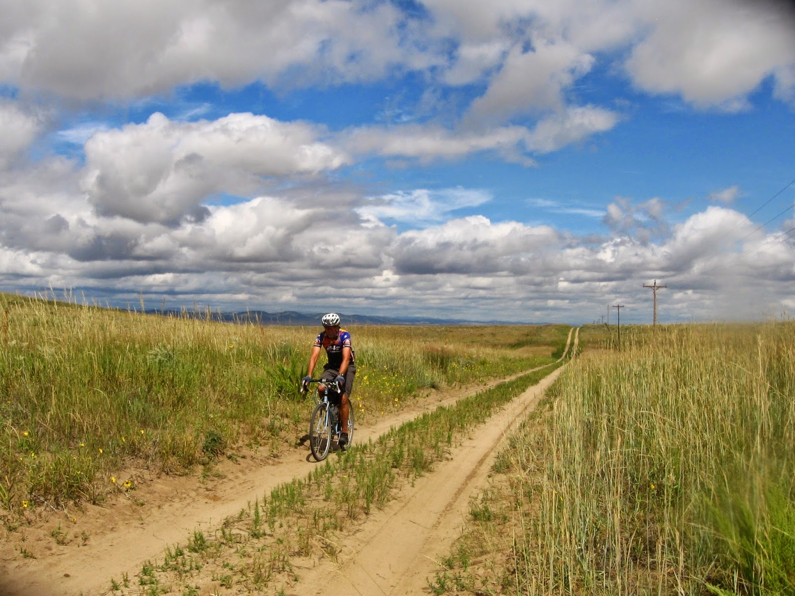
Highland Ridge Road (NPS 5) rolls along a ridge line with sweeping prairie vistas and steadily descends for much of its eleven miles until it t-bones into 7-11 Road.  Check your speed, as I have found loose gravel at the bottom of downhill corners.  Besides, you don't want to miss this landscape or this wildlife.

You think you're fast?  Watch these guys and gals.  60+ mph.
Turn East (left) on 7-11 Road to exit Wind Cave.   For a taste of local folk art, on a good sized scale, look left about 2 miles later.  There, in a pasture, is a metal cowboy on a horse lassoing a 10+ foot tall fire breathing dragon.  If riding the BackBone, this sight appears over 260 miles from the start.  Just a heads up that, at least this, is not a hallucination.


After about five miles on 7-11 Road, you enter the village of Buffalo Gap to return to prairie gravel for a final push to the border.  There's plenty of fun riding ahead, but that was a great stretch right there.

Post Script:  As I said, there are herds of buffalo, elk, pronghorn and deer at Wind Cave.  The above pictures may give the appearance of a few individual animals.  Here's a picture taken last August by riding buddy Shaun Arritola as we rode through a small herd of 50 or so buffalo, maybe more.  Just saying.


Sunday, January 25, 2015

Deerfield Lake to Custer

In designing the route for the Black Hills BackBone, I set out to include my favorite back country roads, with memorable highlights, within the constraints of a generally North to South traverse of the Black Hills.

That can get complicated.  Spinning south of Deerfield Lake, the central Black Hills explode into a confuzzling labyrinth of gravel roads, dirt roads, abandoned roads, wanna B roads, skid trails, hiking trails, and paths.  Some are labeled, perhaps with numbers, letters or numbers and letters.  The roads may be county, state, a division of the state, like the Game, Fish and Parks, or one of smorgasbord of federal agencies.  Some aren't even roads.  They just look like one, until they don't.  I've been misplaced (not lost) on many of these roads.

Classic Central Black Hills granite.

Time to keep it simple.  Kind of.  Some things I just had to include.

That's a sun-lit Crazy Horse Monument back there. 

So, here's the Black Hills BackBone route from Deerfield Lake to Custer, covering about 32 miles.

From Deerfield Lake, take Williams Draw Road (691) south for a splendid 8 mile up and occasional down romp through the pine trees.  This feels every bit as remote as it is.  Embrace it.

Williams Draw Road t-bones into Six Mile Draw Road (301) for a short half mile jog west to Ditch Creek Road (291).  Ditch Creek Road opens it up a bit for another 9 miles or so, but it's still a lot of uphill.  Today it was generally snow-packed, but not too icy.  For the BackBone, this should be a nice rhythm section.

Today's ride on Ditch Creek Road.  Yeah, there's gravel there.
Now, a money view.  From Ditch Creek Road, turn East (left) onto Custer Limestone Road (284), which soon reveals a ridge line view of seemingly the entire southern Black Hills.  Gazing straight east on a clear day reveals Crazy Horse Monument in the distance.  Today, a timely burst of sunshine, poking through an overcast sky, spot lit the carving like it was on Broadway.

Ridge line view, with Crazy Horse Monument.
It's a fun, fast descent down to the meadows below.  Check your speed enough to soak in the scenery.  Good thing there's a short incline 5 and 1/2 miles later, so you don't miss the next turn.  Go South (right) on Upper French Creek Road (286) for a rollicking 6 mile zip line to Custer.  There's progressively more development along this stretch, so keep an eye out for traffic on these narrow, twisty roads.


Upper French Creek Road eventually t-bones into U.S. Highway 16.  Turn East (left) on Highway 16 for about 2 miles into Custer, the first town since Spearfish, over 90 miles ago.  A nice place to rest is Harbach City Park, a block south of Highway 16 on 6th Street and an official trailhead for the Mickelson Trail.  

Saturday, January 17, 2015

The Finish: Oelrichs to NothingThere, Nebraska

Although the journey may be more complex, the destination of the Black Hills BackBone is simple:  the South Dakota border with Nebraska.  I've never been there, at least not on a gravel or dirt road. I needed a visual reference point.  I needed a finish line.

The Black Hills BackBone finish line.  It even says STOP.
I had mapped out a couple of gravel and dirt road routes riding south from Buffalo Gap after dropping out of Wind Cave National Park.  I have ridden many of those roads, but not all.  Today, I left the village of Oelrichs to scout an actual finish line and found it:  an unmarked boundary between South Dakota and Nebraska, where Black Banks Road T-bones into Dakota Line Road in Fall River County, South Dakota.  No town.  No lights.  No markings.  Not even a spot on a regular road map.  Just a STOP sign.  If you want to ceremonially enter Nebraska, you can dip your wheel into the ditch across from Dakota Line Road.  Perfect.

With a finish line in place, I hit the remaining unseen roads and closed some gaps in the BackBone route.  So, here's the last 20 miles of the prospective route, starting about 1 mile east of Oelrichs to the finish line.

From Oelrichs, the Nebraska border is about 13 miles by paved U.S. Highway 385, but is more like 20 miles of rolling prairie gravel.  Spinning south on South Butte Road, the BackBone crosses U.S. Highway 18 about 1 mile east of Oelrichs, turns west a mile later on Milligan Road for a twisty mile of bottom land and then south for a mile on "Old Highway 79."  That designation "old" must be pre-Depression since at least that section of Old Highway 79 is gravel.  And old.

Twisty Milligan Road approaching Old Highway 79.
Then it's west on Antelope Lane, which crosses U.S. Highway 385 before bursting into the wide open prairie.  This is no "lane," but an Antelope Autobahn:  no fences, no obstructions, no limits.  Just go.  Well, there may be some wind, as it is starkly exposed out there.  But I'm sure it will be a tailwind.  Just go.  

Antelope Lane riding west.  No limits.
After four miles of full throttle on Antelope Lane, the BackBone takes Hard Scrabble Road south for 2 miles to connect with west bound Black Banks Road.  Now it's back to big rollers and a final view of the vanishing sky line of the Black Hills, as Black Banks Road heads west for 2 miles.  With a sweeping vista, Black Banks Road then turns 90 degrees for a 9 mile straight shot south to the border at Dakota Line Road.  With each mile, the gravel grows thinner and essentially disappears altogether at the border.

Black Banks Road west bound, with the Black Hills behind.


That's it.  That's the finish line.  I'll celebrate if I make it, but will keep my maps handy.  It's at least 10 miles back to Highway 385, about 20 miles back to Oelrichs, and then another 70 miles to Rapid City.   I think a shuttle would be nice.

Saturday, January 10, 2015

Route Overview - "The Big Picture"

Now, the "Big Picture" of the Black Hills BackBone prospective route.  I have mapped out the proposed route and have ridden or driven most of it, but not all.  The maps spread out over 7 sheets of 11" by 17" paper, but the digital version remains incomplete due to the remoteness of some of the forest gravel roads.  Without getting into turn-by-turn cue sheets, here's something to chew on over a winter weekend.  Grab a map, a cup of coffee and drop into the pace line.

1. The Northern Prairie - North Border to Spearfish (roughly 150 miles)
Pedals start turning in Harding County, South Dakota on Harding County Road 867 at the North Dakota border and less than 3 miles east of the Montana border.  It's a remote, nondescript, inauspicious start, an hour's drive to the nearest village, way out there in the open prairie.  Perfect.  It's also the only option, given that I want to enter the Black Hills from Spearfish and stay west of the heavy, fossil-fueled traffic on the paved highways to the Bakken oil fields.

Actual Geographic Center of United States.
After crossing the Little Missouri River and roughly 90 miles of rolling, remote prairie gravel, the BackBone pays homage to the "Geographic Center of the United States" on Harding Road.  This neglected landmark is the real deal, not the tourist display fabricated in nearby Belle Fouche.  Crossing U.S. Highway 85, the BackBone turns east for a few miles, south below the Belle Fouche reservoir, and then west into Belle Fouche.  Just west of Belle Fouche, it's mostly gravel south into Spearfish, which marks the end of roughly 150 miles of northern prairie gravel.


2. The Black Hills - Spearfish to Wind Cave (roughly 110 miles)
The BackBone ventures into the ancient mountains of the Black Hills via National Forest Road ("NFR") 134 bearing south of Spearfish.  Ahead lies about 30 miles of long, forest gravel climbs up and around Big Hill and Old Baldy, before topping out at O'Neil Pass.  The Forest Service calls NFR 134 a "primary" road, which is relatively wide and maintained, at least for forest gravel.  After a couple of paved miles on U.S. Highway 85, the BackBone again turns south on NFR 231 for a nice cruise to the Black Fox National Forest campground.  Then it's south for another 30 miles to Deerfield Lake on much less developed forest gravel roads, referred to as "secondary" NFRs 233 and 189.  Along this ridge line is a sweet surprise:  fleeting glimpses below and beyond of hundreds of acres of rolling high altitude prairie surrounded by the conifer stuffed Hills.  Deerfield Lake marks roughly 200 miles into the BackBone.

The conifer stuffed and granite spiked Central Black Hills.
South out of Deerfield Lake on secondary NFRs 691, 291, 292 and 286, the BackBone dishes out a relentless series of ups and downs through the very heart of the Black Hills, before dropping onto U.S. Highway 16.  After roughly 30 miles from Deerfield Lake, the couple of miles of pavement east into Custer is a nice break.  Back on forest gravel pedaling south of Custer on Custer County Roads 793 and 336, the BackBone throws down more ups and downs through granite spiked hills.  It eventually spills into a valley sporting the 1887 Cold Spring school house, fully restored in 1965.  Shortly thereafter, a couple of paved miles in Wind Cave National Park lead to more gravel, National Park Service Road 5. You're now clear of the Black Hills.  Prepare to set sail for the open prairie.

3. The Southern Prairie - Wind Cave to the  South Border (roughly 60 miles)
When entering Wind Cave National Park, on a bicycle or otherwise, have your camera handy and lens cap off.  In addition to the stunning landscape, Wind Cave is crawling with critters, large and small.  On every single bike ride through Wind Cave, I have seen deer, elk, pronghorn, buffalo and the ever

Traffic jam in Wind Cave National Park.
barking prairie dog.  Watch out for prairie dog holes on the road itself!  It's a fun, fast 15 mile primarily downhill on prairie gravel to Buffalo Gap.  But don't go so fast you miss this treasure, including some unique yard sculpture just outside Wind Cave of a metal cowboy on a horse lassoing a 15 foot tall, fire-breathing dragon.

South of Buffalo Gap, the BackBone returns to wide open, rolling prairie passing through the villages of Oral, Smithwick and Oelrichs for a final 45 miles to the Nebraska border.

On the road to Smithwick.

 Like the start, the finish is only a spot on the map, and not even that on some maps.  But it will occupy a spot on the heart of all who rode to it on the BackBone.


Sunday, January 4, 2015

Prairie and Forest Gravel - Not your Grandpa Joe's Gravel

The Black Hills BackBone spans 320+ miles from NoWhere, North Dakota to NothingThere, Nebraska, along the spine of the Black Hills of South Dakota, on remote gravel and dirt roads.  Out here in the Northern Plains, you won't find a MidWestern farmland grid system of manicured gravel roads laid out like a celestial square mile checkerboard.  Rather, remote roads out here are very different and come in two distinct flavors:  prairie gravel and forest gravel.


Prairie Gravel

Prairie Gravel - long sight lines and plenty of exposure.

The first 150 miles or so, and the last 60 miles or so, of the BackBone cover remote prairie gravel roads over wide open ranch land and protected National Grasslands having little human presence.  With a small, dispersed population and little development, the roads feature less thick gravel than one generally finds in farmland.  The tracks get packed hard and washboards are rare.  However, if you happen to hit a stretch with the graders out, it can be much worse.  Those counties must be on a triennial plan, so they lay it on thick.


Big prairie sky.

The prairie gravel roads are relatively wide, with two, sometimes three, established vehicle tracks to follow.  Traffic, if any, is light, sight lines can be exceptionally long, and there are few wrong turns to take.  If somehow you get off course,  you may ride many miles without another intersection and the road may simply dead end.  If the South Dakota Department of Transportation map of all roads shows that a road stops or does not connect with another, believe it.  That's my experience.

Also, these prairie gravel roads are exceptionally exposed to the elements and the weather can change rapidly.  One must be prepared to deal with stout winds, scorching sun, fast moving thunderstorms, lightening, tornadoes, and hordes of locusts.  Watch the early afternoon skies, especially from the NorthWest.  That may be a dangerous storm, not your incredible strength, pushing you south at a pronghorn's pace.


Forest Gravel

Forest Gravel - narrow and short sight lines.
Faster when dry.  But these wet roads
revealed mountain lion tracks.

Riding south out of Spearfish, the BackBone climbs into the Black Hills for 100 miles or so of forest gravel.  These narrow mountain roads are built primarily for logging trucks, with little gravel and no shoulders.  They are often just wide enough for two vehicle tracks, if that, so you'll really want to yield to vehicle traffic.  I often dismount off the road.  Fortunately, the logging trucks generally don't run on weekends.

With little gravel or maintenance and with logging truck traffic, the roads are fast when dry, a mess when wet, and prone to erode, often resulting in deep ruts and gullies, fallen rocks, downed trees and other debris.  Sight lines can be very short, as the road twists and turns, up and down, through the Hills.  If you're riding fast, ride light and attentive.


There are many, many gravel roads, dirt roads, skid trails, and other things that look like roads and trails.  Many dead end, eventually.  The BackBone follows roads marked with 3 digit Forest Service signs and County road signs.  If you're on a road with a 4 digit number, or with a letter in addition to the numbers, you are off course.  Go back.


Thursday, January 1, 2015

Introducing the Black Hills BackBone - a remote road ride


In September 2015, I plan to ride the height of the State of South Dakota, from North to South, traversing the spine of the Black Hills on remote forest gravel roads, sandwiched by remote prairie gravel roads extending to the outermost reaches of South Dakota's borders. One long ride. Call it the Black Hills BackBone.


The prospective route spans 320+ miles and 18,000+ feet of elevation gain, with the middle third of that distance and most of that elevation gain immersed within the ancient mountains of the Black Hills. The first and final thirds of that distance cross wide open expanses of broken prairie.  The route covers what I believe are the best of Western South Dakota remote roads, within the constraints of designing a generally North to South cross state ride through the Black Hills.
I'm planning a continuous ride that covers the entire route, a la Trans Iowa and Almanzo Alexandria.  From the current comfort of home, I'd hope for 30-40 hours to ride the BackBone, but I don't know if I can do that.  The gravel out here is great and the scenery is inspiring, but there's a lot of elevation gain in the Hills and a lot of exposure on the prairie.  And there's always the rattlesnakes, mountain lions and buffalo . . .

Resupply opportunities are limited and cell coverage is spotty, at best. Generally, some form of publicly available food, or at least water, is likely every 40-60 miles or so, although there is an 80 some mile stretch up north that's simply prairie. Once in the Black Hills, the roads explode into a labyrinth of up and down roads, paths and trails to ensnare the unprepared and the inattentive.  Reliance on cell phone coverage is not advised.


I'm planning to ride this. Over the years, I've been a race director, race team director, racer, participant, volunteer and/or spectator of about every type of cycling event. This is not an event. This is a bike ride I plan to ride.
That being said, you're welcome to join me, if you're so inclined and prepared. Drop me a line. I can send you my prospective route and help with other details and logistics. Our small Rapid City home and very large yard is available as a base camp. And then, once we turn pedals, you'll be on your own ride.
I plan to post regularly about this ride, including more details and pictures on the route, my bike and gear, nutrition & hydration, resupply possibilities and other logistics.  In the meantime, for a glimpse of what to expect, go to most any of my FaceBook photo albums of western South Dakota gravel rides. The best of those you'll likely see again.