Search This Blog

Thursday, August 25, 2022

Aint Worried 'Bout It Right Now

I don't know what you've been told,
But time is running out, no need to take it slow.
I'm stepping to you toe to toe,
I should be scared, honey, maybe so.

But I aint worried 'bout it right now, (right now)
Keeping dreams alive, 1999 heroes.
I aint worried 'bout it right now, (right now)
Swimming in the floods, dancing on the clouds below.

I aint worried 'bout it.

I Aint Worried, Ryan Tedder, Brent Kutzle, Tyler Spry, John Eriksson, Peter Moren & Bjorn Yttling (2022).

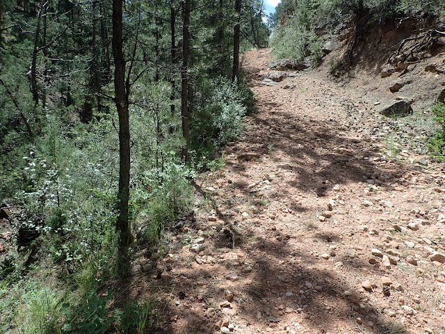
Just another Low Standard Road on the Black Hills Bounty.

The second annual Black Hills Bounty draws nigh. That's a 5 day, off-pavement bikepacking tour of the Black Hills of South Dakota that I created at the request of some out-of-state friends.

Last year, the Black Hills Bounty averaged almost 60 miles and 5,000 feet of elevation gain a day on a smattering of my favorite Forest Service roads in the Central Black Hills. It all came together, despite a seemingly steady stream of audibles that modified each day's ride. It worked out great, mainly because the guys who rode it were great. 2021 Black Hills Bounty Wrap.

Creating the route for this year, I scaled back the distance and elevation gain of each day by about a third to allow more time for navigation, water sourcing, re-supply, camp site selection, optional evening exploratory rides, and, mostly, hanging out at camp. Call it Bikepacking 202. With little more than a digital map and general description from me, each rider will be self-supported, self-navigated, and overall self-sufficient, at least within the context of a small group bikepacking ride. 

These friends are experienced endurance cyclists, so I suppose I should not be surprised at the very few questions from the group about this ride, even at this late date. Maybe I shortened the route so much it looks easy. Maybe the digital maps show all they need to know about the route and terrain. Maybe they've thoroughly prepared and tested bodies, bikes, and gear. Maybe they've researched weather. Maybe they're just flat out ready to ride.

Or maybe this group is like the Top Gun pilots playing Dog Fight Football before their improbable mission. Aint worried 'bout it, right now.

I Aint Worried, OneRepublic (2022).


Thursday, August 18, 2022

The Good, The Bad & The Ugly

The way back to town is only 70 miles. If you save your breath, I feel a man like you can manage it.
Blondie encouraging Tuco, The Good, The Bad & The Ugly (1966).


The United States Forest Service (USFS) categorizes the roads within its boundaries as "Primary Routes," "Secondary Routes," or "Low Standard Routes." That's it. Just three categories for the staggering variety of roads in our national forests.

Well, it's a start. Here's a USFS graphic introducing each category of Forest Service roads.


As an introduction to understanding these categories of roads in the Black Hills National Forest, here are some of my general observations, with representative photographs. Whatever the USFS calls them and however I describe them, every road in the Black Hills will deliver a variety of riding conditions and challenges that change over time. Your eyes on the road and tires on the ground are the best way to know these roads.

Note that the USFS manages extensive logging operations in selected parts of the Black Hills. In large part, that's why most of these roads exist. Yield to all traffic out there, but especially the big logging trucks. And be thankful to be able to ride on the seemingly unlimited roads resulting from their work.


The Good (USFS Primary Route)

The most developed non-paved road in the USFS system is the Primary road, which is designed, built, and maintained for year around, regular travel by standard passenger cars. In the Black Hills, the surface of these roads typically is moderately graveled, hard packed local dirt and limestone that drains water well, and generally does not instantly clog, at least not like Iowa top soil, Nebraska talc, or Oklahoma clay. Some roads are treated with Magnesium Chloride, which hardens and stabilizes the surface.

Primary roads generally are wide enough for opposing motorized traffic to pass easily. If enough gravel exists to form tracks, there would be three or even four. Often a small shoulder will accumulate a bit more gravel that has been pushed off to the side. Relatively high speed vehicle traffic may create washboards and pockets of loose gravel in spots, especially around curves and corners.

My ride of choice for Primary roads is my Alchemy Ronin Titanium gravel bike or my Black Mountain Cycles Monster Cross bike, set up with 40 mm Schwalbe G-One tires. Even when loaded for multi-day bikepacking, these gravel bikes provide plenty of support and control to comfortably ride all day. Relatively speaking, Primary roads are fast.

On USFS maps and signage, a Primary road is designated by brown sign with a number enclosed in a rounded corner, isosceles trapezoid having the longer parallel side on top, as shown below for Boles Canyon Road (117).


The following photographs are representative of USFS Primary roads in the Black Hills.


The Bad (USFS Secondary Route)

The next level of developed, non-paved roads in the USFS system is the Secondary road, which is maintained for high clearance vehicles. In the Black Hills, USFS Secondary roads typically are similar in composition to Primary roads, that is, hard packed dirt and limestone that handles water well and does not overly clog. However, the surface may be even less graveled, or just occasionally graveled, or not graveled at all. Almost certainly, it will not be treated with Magnesium Chloride. Foremost, that means Secondary roads are more susceptible to mud when wet and ruts when dry.

Due to less maintenance, Secondary roads also sport occasional loose dirt, exposed surface rock, pot holes, standing water, and fallen timber, while presenting sharper turns, steeper gradients, and shorter sight lines. Also, Secondary roads typically are two tracks wide, often with little to no shoulder. If a motorized vehicle approaches, I typically pull off the road to allow it to pass. For logging trucks, I definitely leave the road.

All that being said, many Secondary roads in the Black Hills are passable in dry conditions in passenger cars, if attentive to occasional obstacles and clearance issues. For example, I confirmed my cue sheets for the entire Black Hills BackBone route driving my 2006 Chevrolet HHR, hardly a high clearance vehicle. Over the 310 mile route, with many miles of Secondary roads, I maneuvered around a few high-center issues and only had to skirt one fallen tree blocking the road. These roads can be fast, but stay alert.

My ride of choice for most Black Hills Secondary roads is still one of my gravel bikes with 40 mm tires. These roads may be rougher and mountain bike type gearing may be helpful in spots, but most of these roads are developed enough for me on a gravel bike. On the other hand, if loaded for a multi-day ride with significant miles of Secondary roads, I may well opt for my Jones 29+ mountain bike with bigger tires.

On USFS maps and signage, a Secondary road is designated by a three or four digit number enclosed in a brown, rounded corner rectangular sign, as shown below for Williams Draw Road (691).


The following photographs show three USFS Secondary roads in the Black Hills.


The Ugly (USFS Low Standard Route)

The third level of developed, non-paved road in the USFS system is the Low Standard road, which is unimproved and not maintained for automobiles. The Forest Service recommends travel by vehicles with both high clearance and four wheel drive. I would add driver prudence and experience.

Design, construction, and maintenance of Low Standard roads are all over the map, even along a single numbered road. Some sections may be soft dirt, while others are rock gardens. If wet, standing water and mud can be a real issue, leaving deep ruts when dry. Maybe a load of chunky rock was dumped to stabilize a low spot, or maybe not and there's a stream to ford. They are rough, sometimes little more than a bull dozed logging trail. For me, this is mountain bike territory, for tires and gears, even unloaded, for anything more than a short connector.

Many, many, many Low Standard roads are dead-end spurs that were built to get to a spot for logging. Maybe some spurs later connect to something else and haven't made it on a map, or maybe not. I often refer to the USFS Motorized Vehicle Use Maps, which are updated every year and prove to be pretty accurate. However you navigate, count on no cell coverage and no passing traffic of any kind. You are on your own.

If you like this kind of riding, the Black Hills offer a lifetime of miles to explore.

On USFS signage, a Low Standard road is designated with a three-digit number vertically imprinted on short, 4 inch wide, brown carbonite post. On USFS maps, it's just a plain three-digit number. The designation of any road emanating from that Low Standard road adds a decimal and another number. For example, in the Black Hills, USFS 278.1 runs off of USFS 278. Then, any roads running off of USFS 278.1 get letters, the first being USFS 278.1A, then 278.1B, and so on. It can be confusing in the field and USFS map navigation is an entirely separate subject. Just know that any carbonite USFS road sign with a three-digit number, or with decimal numbers, or with letters, identifies a Low Standard Road.

Shown below is a sign for Low Standard road 242, and then one for Low Standard road 325.1D.


The following photographs show a sampling of USFS Low Standard roads in the Black Hills. I captured all of these images while out riding, with the sole exception of the last photograph, which Lucas Haan provided as an example of a deposit of chunky gravel. I included more photographs of Low Standard roads because of their great variety.


To wrap this up, here's a fun rendition of Ennio Morricone's 1966 composition of music for the movie "The Good, The Bad And The Ugly," performed by the Danish National Symphony Orchestra in 2018.

The Good, The Bad And The Ugly, Danish National Symphony Orchestra (2018)


Thursday, August 11, 2022

Connecting

Different strokes for different folks,
And so on, and so on, and scooby dooby doo-bee,
Ooh, sha sha,
We got to live together.
Everyday People, Sly Stone (1968).

Like "boots on the ground" for the Army, there's nothing like "tires on the trail" for scouting back roads. And, in a recurring theme from me, once you're out there, you never know what you'll find.

This little gem is not on my USFS maps.

While creating a five day bikepacking route for some out-of-state friends, I run into a snag. I really want to include roads through two certain areas that are separated by a significant ridge. But no map shows any way to make that connection, absent a relatively large mileage loop around. Even the satellite images on RideWithGPS do not show a clear way through.

One Low Standard Road comes close, abruptly stopping maybe a mile short of another Low Standard Road on the other side. Spurs like that are common in the Black Hills, with primitive roads built just to access areas to log. But this spur does not have that look. I wonder why that road just stops.

The other side of the ridge offers a greater number and variety of roads, with practically no spurs. A couple of maps even show a "spring" in a valley not far over that ridge. If I can cross that ridge somehow and make that connection, I may be able to access both desired areas and a water re-supply.

Time to get out there.

Pretty tame start to this Low Standard Road.

Although I've ridden throughout this area, I have not been on these particular Low Standard Roads. So, I slowly pull off a graveled Primary Road to look for signs. This looks like the right spot, but I'm not alone. In the shade by a small truck, a big pickup, and a trailer, a family of five saddles up horses. They don't look like they're just out for a ride. Not way out here.

As I step out of my Jeep, an older lady strides directly up to me. She's Susan, a rancher who lives nearby and leases USFS land here. Her daughter and family are mounting their horses to move a herd of cattle to a different pasture. She'll haul the trailer down the road to pick them up.

After a brief description of why I'm out there, I ask Susan if I can ask a few questions about the roads and water in this area. She readily agrees, I think mostly out of her general willingness to help and maybe a little out of curiosity.

Spreading out a USFS map on the hood of my Jeep, I ask her whether 1) this area is USFS land, not private; 2) this Low Standard Road goes through to this marked spring, even though the map says it doesn't; and 3) this spring has fresh water. Yes, Susan replies, to all of it. She says they run cattle through there, but stopped using that old road over the years as it deteriorated and instead access the spring from the other side. But she thinks I can get still get through on a mountain bike. She adds that her family installed a pipe to directly access that spring and that fresh spring water flows continuously all year.

Well, alright! How's that for local intel! Thanks, Susan!

Another part of the "not-on-a-map" connector.

Of course, I hop on my bike to check it out. The Low Standard Road flows smoothly along a mellow meadow for the first 2-3 miles, before dissipating into solid knee-high grass. Looking at the land and my maps, I reckon the "road" must generally go this way, if it's going through. So, I hack my way through the grass for a bit before spotting the makings of a road ahead.

This must be the way, but now it's rough. Rocky. Loose. Sometimes steep. But it's definitely an old road and it's heading in the right direction. And it's rideable, at least on my unloaded mountain bike.

Sure enough, after about a mile of that rough stuff up and over a ridge, I emerge onto an actual Low Standard Road and drop into another meadow. There it is. A large water tank fed by a pipe with steadily flowing water. Cool beans.

Although the water in the tank looks a bit saucy, there's a pipe feeding fresh spring water into it.

What a day! I find a really nifty, unmapped connector that very few people likely know about, let alone ride, and that pops out to a reliable source of fresh spring water. There's even ample space to disperse camp along the meadow, if desired. This connector solves some big routing issues for me and will be a nice add to the trip.

I lightly spin back to my Jeep to find Susan and her family picking up their shuttle truck. She introduces me to everyone and asks what I think about the road and water. And they all want to hear more about the bikepacking trip. They live right out here and are excited to see others enjoying this special place.

I just want to hear what it's like to be a grade schooler herding cattle by horseback through the forest. That sounds like a grand adventure to me. Susan's grandson shrugs. All in a day's work.

As usual, the best connection made today is with the people met along the way.


Everyday People, Sly & The Family Stone (1968).

Thursday, August 4, 2022

A Simple Cup Of Coffee

I will follow him,
Follow him wherever he may go,
And near him I always will be,
For nothing can keep me away,
He is my destiny.
I Will Follow Him, Frank Pourcel, Paul Mauriat, Arthur Altman & Norman Gimbel (1962).

Sitting at a picnic table by the Berlin Wall Memorial on a gorgeous Saturday morning, I fire up the stove to brew my first cup of coffee. The city is slowly awakening, as walkers, runners, and cyclists occasionally pass by. This is a peaceful little spot away from the main bike path, so most probably don't notice me sitting there in the shade.

But one guy did. He was walking directly from Rapid Creek across the grass some distance from me toward the Civic Center parking lot. Carrying a gas station coffee cup and a small towel over his shoulder, he smiles and waves. I acknowledge and yell, "Would you like a cup of hot coffee? I'll make it right here!"

No hesitation. He strides right over to me and changes my day.

John preparing to leave for his next calling.

As he approaches, I see a face that simply glows with peace and joy. He thanks me for the invitation and wants to know all about me and what I'm doing. I tell him this is simply an early start to this month's #CoffeeOutside - Rapid City, an informal, outdoor gathering of the local cycling community over coffee. I'd be happy to brew a fresh cup for him. And here's some relatively healthy treats to go with it.

He says it all looks awesome. His name is John, but he really wants to hear more about Coffee Outside and how I brew coffee right there on a picnic table. So, I talk of our little community and go through my process with a JetBoil stove, freshly ground coffee, and AeroPress filtering system. With his first sip, he closes his eyes and sighs deeply, "Ahh. That's good coffee." Then, he slowly starts to talk.

CoffeeOutside groups in the United States.
(image from pathlesspedaled.com)

John is a man currently living out of a truck, but he's not broke and he's not homeless. Far from it. He's a man on a mission.

Not long ago, John worked a steady construction job in Chicago, lived in a good part of town, and thought he had the world by the tail. When a girlfriend started dabbling in meth, John joined that scene and quickly spiraled out of control. Darkness and hopelessness enveloped his world, threatening his very life. 

Somehow, at those depths, John saw a light. He saw Jesus. He gave his life to Jesus and instantly changed.

John sold or gave away most everything, packed up a few things in his truck, and asked God where to go to serve. Right then, as he was leaving Chicago on I-90 near O'Hare Airport, the music in his truck abruptly stopped and an electronic billboard overhead flashed "Nebraska, The Good Life."

So, John headed to Nebraska and, along the way, learned of the store in White Clay that sells millions of cans of beer annually to residents of Pine Ridge Indian Reservation. That's it. He drove directly to Pine Ridge, knowing nobody there and nothing of the culture.

Initially facing opposition and even hostility, John says that he simply made himself available to others, served as able, and eventually was accepted by the community. About a month later, John heard a new calling to go to Rapid City. So, he reluctantly left Pine Ridge.

In Rapid City, he immediately landed a construction job and continued to serve. He had been here for about a month before hearing his next calling to go to Polson, Montana. Again, John reluctantly decided to leave because he believed that's where God called him to go.

Before John left Rapid City, however, a local minister agreed to baptize him. That's why John carried a small towel. He had just been baptized in Rapid Creek moments before stopping by for coffee. Wow.

That explains his sparkling eyes, undeniable joy, and inner peace. John is a new man with a servant's heart. And he's out there listening to God's voice and following it.

What a blessing to share this time with him. All starting with a simple cup of coffee.

Go, in peace, John. Praise God.

I Will Follow Him, Peggy March (1963)

I Will Follow Him, Sister Act (1992).