Search This Blog

Showing posts with label usfs road. Show all posts

Sunday, March 12, 2023

Five Favorite Black Hills "Low Standard" Roads

Last week I posted my "Five Favorite Black Hills 'Gravel' Roads," which included only USFS Primary and Secondary roads. See Five Favorite Black Hills "Gravel" Roads. In general, those roads are great fun for experienced cyclists on gravel bikes with tires of 40 mm or wider. But that's only the beginning.

Spinning off those many miles of Primary and Secondary roads, countless Low Standard roads wriggle into practically every nook and cranny in the rugged Black Hills. Some connect to other roads, some stop at logging areas, and some simply dissipate into the forest. For me, this is mountain bike territory, whether loaded or unloaded, for all but short connectors.

I explore many miles of Low Standard roads every year. To identify the best five Low Standard roads, out of hundreds, is impossible. And any such list is necessarily dated, as I continue to discover more every year.

Nonetheless, just for fun, here are five, currently favorite Black Hills Low Standard roads, or combinations of Low Standard roads, that connect something. Note that these roads are identified on a USFS map by a number, which may or may not appear on a sign out there.

1. Bear Spring (USFS 681/284.2L/284.2A)
USFS 681/284.2L/284.2A along Bear Spring Creek to Alkali Spring.

USFS 681 starts from U.S. Highway 16 looking to be a pretty well developed back road to connect with Custer Limestone Road (USFS Primary Road 284) in about 8 miles. However, USFS 681 turns onto USFS 284.2L, which deteriorates as it enters Hell Canyon to follow Bear Spring Creek, where the walls close in. If that is flooded, I head back to Bear Spring and take a different Low Standard Road (USFS 284.2B/284.2C) that traverses the adjacent hillside to the East to connect with Custer Limestone Road.

A rare sign along a Low Standard road in the Black Hills.


2. Booms Canyon (USFS 682/335.1D/335)
USFS 682/335.1D/335 to disperse camp near Booms Canyon.

Whether coming off of Wildcat Canyon (USFS Secondary Road 682) or Argyle Road (USFS Primary Road 333), this little 5 mile loop is a nice break on rough two track into an island of National Forest surrounded by private land. The initial rocky descent climbs back up to a ridge with 360 degree views and some cover for dispersed camping. This little chunk of isolated Black Hills National Forest solved a camping problem for me when scouting the route for Day 4 of the 2021 Black Hills Bounty. 

USFS 335.1D enroute to Booms Canyon.


3. Burnt Fork (USFS 389/389.1F/389.1D/530.1A/530)
USFS 389/389.1F/389.1A/530.1A/530 on classic Black Hills Low Standard Roads.

Starting from Deerfield Lake Road and the Mickelson Trail, Burnt Fork Road (USFS Secondary Road 389) rolls past small ranches to the restored Gold Mountain Mine, which is well worth the short hike. Shortly thereafter, USFS 389.1F climbs along Friday Gulch to eventually drop down USFS 530.1A to Slate Creek. These are classic Low Standard roads in the Black Hills:  a constantly changing mix of surfaces and pitches, up and down, through dense pine forests with occasional big views, a creek prancing down a craggy valley, and even an active logging area. After almost 12 miles, it pops out at the Mickelson Trailhead and on Mystic Road near the Redfern Trailhead.

USFS 530.1A dropping toward Slate Creek.


4. McKenna Springs to Jewell Cave (USFS 270.1A/270.1Z/unnumbered/277)
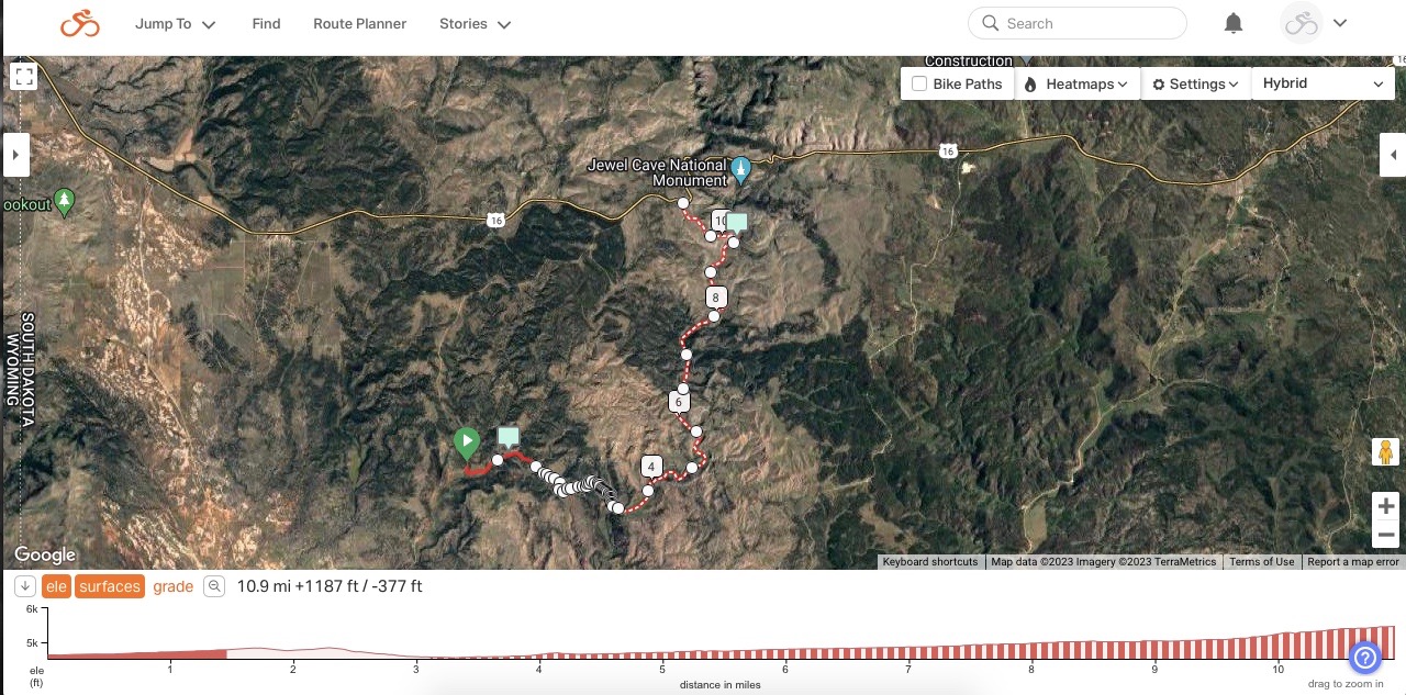
USFS 270.1A/270.1Z to unnumbered/abandoned road to USFS 277.

I discovered this little gem while scouting for a connector between Schenk Canyon and Hell Canyon for Day 4 of the 2022 Black Hills Bounty bikepacking ride. See Connecting. This 11 mile connector starts from Mann Road (USFS Secondary Road 270), turns onto USFS 270.1A as a mellow double track, turns more rough onto USFS 270.1Z, dissipates into nothing but tall grass for a hundred yards or so, and re-appears as a rocky, unnumbered, abandoned road that does not appear on a USFS map. Drop down that rocky pitch to McKenna Spring for fresh water, dispersed camping, and a short two track to USFS 277, which winds north to U.S. Highway 16 near Jewell Cave National Monument. 

This may well be my all time favorite Low Standard road find.

Unnamed and unnumbered abandoned road not on a USFS map.
McKenna Spring lies at the bottom of this hill in about a mile.


5. Bear Mountain (Unnumbered/unnamed to USFS 285.1A)
Unnamed/unnumbered road to USFS 285.1A to Saginaw Road.

Just west of the Bear Mountain Lookout Tower lies a nice clearing to disperse camp with an unnamed, unnumbered two track leading south. For about 3 miles, that gentle two track winds through aspen trees, hinting of hills to come. Then it rounds a corner to reveal a fleeting view of Crazy Horse Memorial before dropping onto USFS 285.1A for another 3 quick miles to Saginaw Road (USFS Primary Road 285). I discovered this route after finding that the Forest Service had barricaded with barbed wire my planned rough road descent off Bear Mountain. It all worked out, as I scouted around to find this great little, unnamed, unnumbered road.

Streaming off Bear Mountain on an unnamed,
unnumbered two track that leads to USFS 285.1A.

So many other Low Standard roads could have made this list, such as Galena north on USFS 567.1C/567.1/172.1; Hawkright Canyon on USFS 275; Pilger Mountain on USFS 319; Idol Gulch to Pole Cabin Gulch to Cement Ridge on USFS 803.1/802.1/1603; Richardson Cut-Off on USFS 276; Rifle Pit Canyon on USFS 806.1; Rhoads Spring on USFS 189; and Gillette Canyon on unnamed USFS 383. As a practical matter, there is a lifetime of Low Standard roads in the Black Hills to explore.

Going forward, maybe I should write an annual post identifying five favorite Low Standard roads that I discovered that year. I know I won't run out of material.

Sunday, January 22, 2023

The Good, The Bad & The Ugly (updated)

The way back to town is only 70 miles. If you save your breath, I feel a man like you can manage it.
Blondie encouraging Tuco, The Good, The Bad & The Ugly (1966). 


The United States Forest Service (USFS) categorizes the roads within its boundaries as "Primary Routes," "Secondary Routes," or "Low Standard Routes." That's it. Just three categories for the staggering variety of roads in our national forests.

Well, it's a start. Here's a USFS graphic introducing each category of Forest Service roads.

As an introduction to understanding these categories of roads in the Black Hills National Forest, here are some of my general observations, with representative photographs. Whatever the USFS calls them and however I describe them, every road in the Black Hills will deliver a variety of riding conditions and challenges that change over time. Your eyes on the road and tires on the ground are the best way to know these roads.

Note that the USFS manages extensive logging operations in selected parts of the Black Hills. In large part, that's why most of these roads exist. Yield to all traffic out there, but especially the big logging trucks. And be thankful to be able to ride on the seemingly unlimited roads resulting from their work.


The Good (USFS Primary Route)

The most developed non-paved road in the USFS system is the Primary Route, which is designed, built, and maintained for year around, regular travel by standard passenger cars. In the Black Hills, the surface of these roads typically is moderately graveled, hard packed local dirt and limestone that drains water well, and generally does not instantly clog, at least not like Iowa top soil, Nebraska talc, or Oklahoma clay. Some roads are treated with Magnesium Chloride, which hardens and stabilizes the surface.

Primary Routes generally are wide enough for opposing motorized traffic to pass easily. If enough gravel exists to form tracks, there would be three or even four. Often a small shoulder will accumulate a bit more gravel that has been pushed off to the side. Relatively high speed vehicle traffic may create washboards and pockets of loose gravel in spots, especially around curves and corners.

My ride of choice for Primary Routes is my Alchemy Ronin Titanium gravel bike or my Black Mountain Cycles Monster Cross bike, set up with 40 mm Schwalbe G-One tires. Even when loaded for multi-day bikepacking, these gravel bikes provide plenty of support and control to comfortably ride all day. Relatively speaking, Primary Routes are fast.

On USFS maps and signage, a Primary Route is designated by brown sign with a number enclosed in a rounded corner, isosceles trapezoid having the longer parallel side on top, as shown below for Boles Canyon Road (117). 


The following photographs are representative of USFS Primary Routes in the Black Hills.


The Bad (USFS Secondary Route)

The next level of developed, non-paved roads in the USFS system is the Secondary Route, which is maintained for high clearance vehicles. In the Black Hills, USFS Secondary Routes typically are similar in composition to Primary Routes, that is, hard packed dirt and limestone that handles water well and does not overly clog. However, the surface may be even less graveled, or just occasionally graveled, or not graveled at all. Almost certainly, it will not be treated with Magnesium Chloride. Foremost, that means Secondary Routes are more susceptible to mud when wet and ruts when dry.

Due to less maintenance, Secondary Routes also sport occasional loose dirt, exposed surface rock, pot holes, standing water, and fallen timber, while presenting sharper turns, steeper gradients, and shorter sight lines. Also, Secondary Routes typically are two tracks wide, often with little to no shoulder. If a motorized vehicle approaches, I typically pull off the road to allow it to pass. For logging trucks, I definitely leave the road.

All that being said, many Secondary Routes in the Black Hills are passable in dry conditions in passenger cars, if attentive to occasional obstacles and clearance issues. For example, I confirmed my cue sheets for the entire Black Hills BackBone route driving my 2006 Chevrolet HHR, hardly a high clearance vehicle. Over the 310 mile route, with many miles of Secondary Routes, I maneuvered around a few high-center issues and only had to skirt one fallen tree blocking the road. These roads can be fast, but stay alert.

My ride of choice for most Black Hills Secondary Routes is still one of my gravel bikes with 40 mm tires. These roads may be rougher and mountain bike type gearing may be helpful in spots, but most of these roads are developed enough for me on a gravel bike. On the other hand, if loaded for a multi-day ride with significant miles of Secondary Routes, I may well opt for my Jones 29+ mountain bike with bigger tires.

On USFS maps and signage, a Secondary Route is designated by a three or four digit number enclosed in a brown, rounded corner rectangular sign, as shown below for Williams Draw Road (691).


The following photographs show three USFS Secondary Routes in the Black Hills.


The Ugly (USFS Low Standard Route)

The third level of developed, non-paved road in the USFS system is the Low Standard Route, which is unimproved and not maintained for automobiles. The Forest Service recommends travel by vehicles with both high clearance and four wheel drive. I would add driver prudence and experience.

Design, construction, and maintenance of Low Standard Routes are all over the map, even along a single numbered road. Some sections may be soft dirt, while others are rock gardens. If wet, standing water and mud can be a real issue, leaving deep ruts when dry. Maybe a load of chunky rock was dumped to stabilize a low spot, or maybe not and there's a stream to ford. They are rough, sometimes little more than a bull dozed logging trail. For me, this is mountain bike territory, for tires and gears, even unloaded, for anything more than a short connector.

Many, many, many Low Standard Routes are dead-end spurs that were built to get to a spot for logging. Maybe some spurs later connect to something else and haven't made it on a map, or maybe not. I often refer to the USFS Motorized Vehicle Use Maps, which are updated every year and prove to be pretty accurate. However you navigate, count on no cell coverage and no passing traffic of any kind. You are on your own.

If you like this kind of riding, the Black Hills offer a lifetime of miles to explore.

On USFS signage, a Low Standard Route is designated with a three-digit number vertically imprinted on short, 4 inch wide, brown carbonite post. On USFS maps, it's just a plain three-digit number. The designation of any road emanating from that Low Standard Route adds a decimal and another number. For example, in the Black Hills, USFS 278.1 runs off of USFS 278. Then, any roads running off of USFS 278.1 get letters, the first being USFS 278.1A, then 278.1B, and so on. It can be confusing in the field and USFS map navigation is an entirely separate subject. Just know that any carbonite USFS road sign with a three-digit number, or with decimal numbers, or with letters, identifies a Low Standard Route.

Shown below is a sign for Low Standard Route 242, and then one for Low Standard Route 325.1D.


The following photographs show a sampling of USFS Low Standard Routes in the Black Hills. I captured all of these images while out riding, with the sole exception of the last photograph, which Lucas Haan provided as an example of a deposit of chunky gravel. I included more photographs of Low Standard Routes because of their great variety.


To wrap this up, here's a fun rendition of Ennio Morricone's 1966 composition of music for the movie "The Good, The Bad And The Ugly," performed by the Danish National Symphony Orchestra in 2018.

The Good, The Bad And The Ugly, Danish National Symphony Orchestra (2018)