Slow down, you move too fast You got to make the morning last Just kicking down the cobblestones Looking for fun and feeling groovy The 59th Street Bridge Song, Paul Simon (1966)
I don't need much of an excuse to ride my bike, meet with friends, or drink coffee. So, when Lucas Haan notified me of the 2020 Coffeeneuring Challenge, I jumped in. And, unlike our #CoffeeOutside - Rapid City gathering every Thursday morning, this one doesn't require sitting outside early morning, unless, of course, that's what you want to do.
From her website ChasingMailboxes.com, endurance athlete Mary Gersema describes the concept: "The Coffeeneuring Challenge is a time to spin the wheels, experience the chill of fall as it pokes at you through your clothes, and linger over a steamy cup of coffee. The challenge offers an opportunity to virtually connect with others as we ride through shorter days and changing seasons."
"Essentially the challenge boils down to this:
over the course of 7-ish weeks,
ride your bike to 7 different places,
at least 2 miles round trip each time,
drink 7 cups of coffee (or similar), and
take 7 pictures (or other documentation) as proof of your coffeeneuring."
It's a fun twist. Among other things, Coffeeneuring led me to relax for a change by the "M" on M-Hill, to ride along on another's commute to work, to stop for a moment while scouting remote roads in the Black Hills, and even to ride straight up a temporary construction path to access some single track.
To submit the requested documentation to complete my first Coffeeneuring Challenge, I am Craig Groseth of Rapid City, South Dakota, USA and below are my completed control cards and pictures for seven rides. Thank you, Mary, for creating and nurturing this community of Coffeeneurs.
Ride 1
Ride 2
Ride 3
Ride 4
Ride 5
Ride 6
Ride 7
Here's Simon & Garfunkel "feeling groovy" at The Concert At Central Park in New York City in 1981. For a trip further down and even past Memory Lane for many, watch the second clip of Simon & Garfunkel on the Smothers Brothers Comedy Hour in 1967, where the Smothers Brothers join in.
The 59th Street Bridge Song, Simon & Garfunkel, The Concert At Central Park (1981).
The 59th Street Bridge Song, Simon & Garfunkel, Smothers Brothers Comedy Hour (1967).
The Cloud Peak 500 is a 500 mile remote road loop in and around the Big Horn Mountains of Wyoming. This post is part of a series that describes some of each day's logistics involved when we rode the route on bicycles loaded for a 7-8 day self-supported tour in early August 2020. It also includes a screen shot and link to a digital map on ridewithgps.com, which I created after the trip to show our ride for each separate day. Finally, it adds a photo gallery. This post covers Miles 434-490 of the route, which was Paul's final day. Go to Miles 0-52 for Logistics for Day 1, go toMiles 52-104 for Logistics for Day 2, go to Miles 104-151 for Logistics for Day 3, go to Miles 151-201 for Logistics for Day 4, go to Miles 201-251 for Logistics for Day 5, go to Miles 251-299 for Logistics for my Day 6, go to Miles 299-356 for Logistics for my Day 7, and go to Miles 356-434 for Logistics for Paul's Day 7.
After winding 434 miles of up, down, and along the Big Horn Mountains in a mammoth counter-clockwise loop, the Cloud Peak 500 strikes for the eastern prairie for a rolling 56 miles from Buffalo to the finish in Sheridan. Know that no commercial establishments exist on route for re-supply, despite what appear to be towns on a map. This section is a welcomed break from all the previous days of long, hot climbs and is a fitting finish for this self-supported tour.
Paul starts his Day 8 from the town of Buffalo at an elevation of about 4,600 feet and finished the day, and the Cloud Peak 500 route, 56 miles later at the town of Sheridan at an elevation of about 3,800 feet. The first 23 miles roll generally downhill along Clear Creek on Kumor Road (40), then Belus Road (102), then Box Elder Road (171), and finally merging with U.S. Highway 14 for 2 miles to "Ucross." All these roads are straight forward to navigate and good, solid gravel to ride.
Ucross appears to be a town on my maps, but it is not. Rather, it is an art studio, gallery, and/or museum of some sort that may be open to the public during other days, hours or times. It certainly is not a place for a traveling cyclist to re-supply provisions. That is also true for all the other spots that appear to be towns along these 56 miles. Carry what you need for this stretch.
Just a half mile after "Ucross," the route turns NorthWest onto Coal Creek Road (195). Here starts the biggest "climb" of the day, about 600 feet of elevation gain over the next 6 miles. Relatively speaking, this is a bump in the road on the Cloud Peak 500.
Cresting that rise, the route drops a mile into "Ulm," another non-town. Continue north on Ulm Road (42), which gently rolls down a valley for about 14 miles to Wyarno Road (84). Just 3 miles later, the route turns onto Wildcat Road (84), which winds and rolls about 5 miles before merging with 336 to enter Sheridan.
These roads are straight forward to navigate and follow. Other than a several mile stretch of fresh gravel that Paul rode into in mid-August 2020, these roads are relatively good, solid gravel roads for the prepared cyclist.
And it all might come together And it all might come unraveled On the road less traveled. The Road Less Traveled, Buddy Brock & Dean Dillon (2001)
After five days of riding the Cloud Peak 500, Paul Brasby and I face the facts. We're running out of time. We need to dramatically increase our daily mileage over the next three days or we will finish short. Decision time. Early on Day 6, we discuss options and leave Ten Sleep with a plan. I wrote about my Day 6 in Decision Day and my Day 7 in High On A Desert Plain. Paul wrote about his Day 6 in Ghost Rider In The Sky , wrote about his Day 7 in the post Wonder Where I'm Bound , and writes about his final day here.
After 7 days, 5 hours and 30 minutes, Paul Brasby is the first and only official finisher of the Cloud Peak 500. From one who was out there with him for 5+ days working those climbs in that August heat, I will paraphrase the legendary Steve Prefontaine to say that somebody may beat that time, but they're going to have to bleed to do it.
I checked the weather for tomorrow before I called it a night. It showed for a hot day in the high desert plains with temperatures in the 90's. I set my alarm for 6:30 am, so I can get an early start before the Mercury starts to rise.
I'm up before the alarm goes off and before long I'm packed and ready to go. It's time to close the book on the Cloud Peak 500.
The route follows river valleys for most of the day to Sheridan, with minimal elevation gain. Climbing to cooler temperatures is not possible.
A quick stop at a convenience store for coffee, hot sandwich, a bag of trail mix, and a quick text message to Craig. I'm back on the road by 7:15 am. The air is cool, as the magical hour for photography is in full swing. I quickly get back on the route and hit gravel soon after. The roads are fast and relatively flat. Once again, I enjoy a slight tailwind.
I was expecting today's route to be a boring, dry desert-like ride, with very little to perk my interest. But was I wrong! Just the opposite happened. I find myself riding in lush valleys with native grasses and alfalfa fields growing strong, ready for another cutting.
Grassy hills, void of trees, covered in green grass jetting upward from the valley floor in all shapes and sizes. Ridge lines form on both sides of the valleys for most of the day. I find myself rubber-necking, as I enjoyed the scenery, like watching a tennis match from the front row at center court. With the early morning light, it made for stunning shadows across the valleys. The roads were flowing through the prairie grass like a freshly laid red ribbon of satin. It was beautiful!!!
I found myself following bicycle tire tracks early on and they appeared to be a set of skinny gravel tires. In the distance, I can see the gravel road abruptly changing from a grey to red color. As I approach the new color of gravel, I noticed the tire tracks made a U-turn in the road and headed back for Buffalo. A local, I figured, doing an out and back.
Well, I quickly discovered why they did. The new color of red gravel was 6 inches of freshly laid pea gravel. Holy Cow!!! Thank God I had 2.2 inch tires on the Cutty. They were just enough to give me the float I needed to stay on top of the loose stuff! This went on for several miles and I was happy to see it end!
I left Buffalo with 3.8 liters of water and I used every bit of it during this leg. The towns dotting the map really aren't towns for the most part. Don't plan on using any of them for refueling purposes!!!
As the day pushes into late morning, the temperature rises with the short hand of the clock. My spirits are increasing with every pedal stroke, as it means I'm getting closer to the end of my journey. The miles are flying by, in epic proportion to the rest of the trip!
I text Crag and fill him in on my location. Craig is as much a part of this finish as it is for me! He may not be riding it with me, but he is with me in spirit. We started this epic adventure together and we're going to finish it together! Because of him, I am here, just miles away from the end of the Cloud Peak 500!
I'm in another valley heading west on WildCat Road following the BNSF railroad tracks. The route makes a change of direction with a series of right and left turns, as it works its way southwest toward Sheridan.
Because of the rolling hills, I can't see the city at all. My computer that started with 486 miles now shows only two! I ride over the last couple of hills and the city of Sheridan now comes into full view. It is literally all down hill from here.
What an amazing, hard fought ride that was. WOW!!!
My computer chirps at me to let me know I crossed the virtual finish line, as I swing into a pay only gas station and motel across the parking lot to take a few pictures. I hop back on my bike and roll to where Craig and I started our adventure . . . 7 days 5 hours and 30 minutes ago!
WE MADE IT!!!
I would like to give a big shout out to Aaron Denberg and his wife Sarah Wallick of Big Horn, Wyoming for putting this route together for all of us to enjoy! In my 42 years of riding, this was the toughest multi-day I've done to date!!! Thank You for an Epic Adventure and for giving us the opportunity to play in your back yard!!!
I happened to come across Craig's blog post about the Cloud Peak 500 and the thought of riding with a friend intrigued me. Thank you Craig for inviting me to tag along and for your friendship on this Epic Journey. I look forward to riding with you again in the back country. Just say when and where!!!
The Cloud Peak 500 is a 500 mile remote road loop in and around the Big Horn Mountains of Wyoming. This post is part of a series that describes some of each day's logistics involved when we rode the route on bicycles loaded for a 7-8 day self-supported tour in early August 2020. It also includes a screen shot and link to a digital map on ridewithgps.com, which I created after the trip to show our ride for each separate day. Finally, it adds a photo gallery. This post covers Miles 356-434 of the route, which was Paul's Day 7. Go to Miles 0-52 for Logistics for Day 1, go toMiles 52-104 for Logistics for Day 2, go to Miles 104-151 for Logistics for Day 3, go to Miles 151-201 for Logistics for Day 4, go to Miles 201-251 for Logistics for Day 5, go to Miles 251-299 for Logistics for my Day 6 and go to Miles 299-356 for Logistics for my Day 7.
Right from the start, this day's climb gains over 3,600 feet in the first 22 miles and that's only half of the climbing over its 77 miles. Expect soft roads, virtually no shade, no development, and no water for at least 40 miles. Once again, however, the final descent eventually pays off, here down Crazy Woman Canyon.
Paul starts his Day 7 from the town of Kaycee at an elevation of about 4,600 feet. The first 12 miles climb steadily on Mayoworth Road (191) through dry prairie sloping up the arid mountainside. Mayoworth comprises a couple of homes and has no commercial establishments. Enjoy the glimpses of green vegetation at this intersection before grinding up another long, hot, dry, soft climb.
From Mayoworth, the route turns onto Slip Road (67), which starts innocently enough by continuing to climb steadily for about 4 miles. At about mile 16, however, Slip Road tosses aside the facade to show its true character. The next 6 miles climb over 2,500 feet.
Yes. That's right. Over 2,500 feet of elevation gain in 6 miles. Not surprisingly, it takes 18 switchbacks to do that. And this soft road offers no shade, no water and no shelter. Virtually no traffic.
After that effort, one receives the shortest of respites before climbing again. At about 30 miles, Slip Road merges into Hazelton Road (3), which continues to roll upwards. Eventually, Paul stopped at a road sign that noted 36 miles down to Kaycee. He rode 7 hours that day to reach that sign. Not until after about 40 miles is the climbing pretty much over. No water anywhere. That's a long, hot, hard day.
The route rolls along Hazelton Road. At about mile 49, shortly before reaching U.S. Highway 16, the route turns off Hazelton Road and follows a serpentine path through a patchwork of roads and trails. Follow your GPS or detailed cue sheets. The following is a general description only. As I discerned, the route turns off Hazelton Road downhill onto Billy Creek Road (USFS 466) for about a mile, turns onto USFS 622 for about another mile, meanders for about another mile to turn onto USFS 473 for about 2 miles, turns onto USFS 33 to finally enter Crazy Woman Canyon.
Crazy Woman Canyon (33) is the road highlight of the day, dropping about 2,600 feet over 10 miles of crazy cool canyon. The road surface is hard and fast, but the road carries traffic and is very narrow, often single lane. Check speeds regularly.
At about 67 miles, the route turns north onto Klondike Road (132) for a prairie rolling 10 miles into the town of Buffalo. Full services available here, including motels and restaurants.
It's a long and a dusty road It's a hot and a heavy load And I can't help but wonder where I'm bound. I Can't Help But Wonder Where I'm Bound, Tom Paxton (1964)
After five days of riding the Cloud Peak 500, Paul Brasby and I face the facts. We're running out of time. We need to dramatically increase our daily mileage over the next three days or we will finish short. Decision time. Early on Day 6, we discuss options and leave Ten Sleep with a plan. I wrote about my Day 6 in Decision Day and my Day 7 in High On A Desert Plain. Paul wrote about his Day 6 in Ghost Rider In The Sky and writes about his Day 7 here.
After a well deserved night's sleep and my batteries recharged, I pack up and head out the door in search of a quick breakfast. I also need to swing by the Kaycee RV Park to square up with Kristy for the hunter's cabin I stayed in. FYI - you need exact cash to pay for the cabin and there's an ATM west of the Interstate at the local Sinclair convenience store on your way out of town on the bike route. It's also across the street from the Kaycee RV Park where Craig stayed at. I stayed at their other campground on the south side of town at the Powder River Campground on the bike route as you roll into town.
I took advantage of a well stocked store with hot breakfast food and a sub sandwich kitchen in the rear of the Sinclair store. They also had seating available, so I sat down, enjoyed my breakfast and caught up on what's going on in the world on TV. While I ate, I couldn't help but admire the large elk mounts hanging all around me. We are definitely in big elk country.
After a quick stop at the Kaycee RV Park and a big thank you to Kristy for a very comfortable night's sleep, I'm back on the road again, bound for the town of Buffalo, 78 miles away.
The morning started out a little on the late side due to sleeping in and now I find myself in warmer temperatures than I had hoped for at 9 am. A light wind was at my back and the first six miles or so were on paved roads, gradually riding up a nice grassy valley. I took advantage of cell service to send Craig a text message on where I was and where to stay in Kaycee.
My legs were feeling good at the moment, but the true test would be on Slip Road, when the road goes vertical for miles. On the elevation chart, the Slip Road portion jetties straight up off the page like Wyoming's great Devil's Tower, with its sheer wall face looking down on you from above.
After a few miles, the wind shifts to a head wind as I turned left onto Slip road. I couldn't help but stop and take a picture of a sign I've never seen before. "NO SEMI-TRUCKS, RVs, TRAILERS BEYOND THIS POINT, NARROW WINDING CANYON ROAD AHEAD." It got an exuberant thumbs up from me at the moment, but had I known what laid ahead of me, I'm not sure I would have given it one!! Within the first mile, I find myself walking already, with short punchy climbs leading me to the base of the main climb of the day.
Slip Road is the toughest climb of the trip by far!! With its 18 switchbacks and sustained gradients of 14-18%, Slip Road wears on you! The road is firm with good gravel and at times with good tree cover, but the corners of the switchbacks are steep, loose, and littered with washboards. That's what I call "all in corners!" After a stretch of non-stop switchbacks, the road straightens out and reaches for the sky. At that point, I had to start walking on and off for the next two hours.
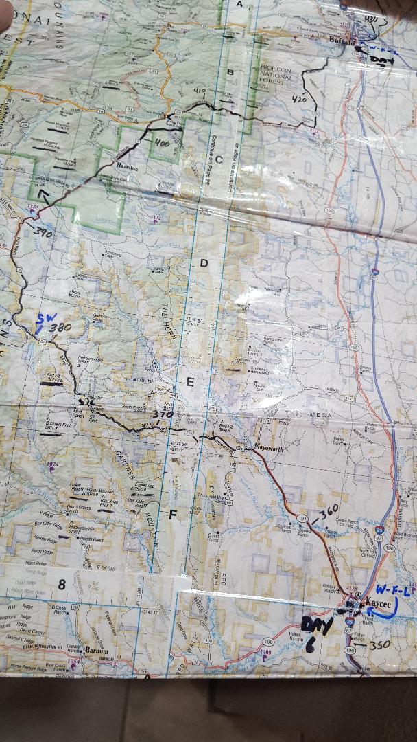
Zoom in on Slip Rd in the background
At one point, I was stretched out with my hands above my head on the brake hoods and my feet parallel with my rear wheel, pushing my bike uphill at a gradient that felt like 50%. I'm sure it was more like 18%, but it was steep! At that moment, two ladies pulled up along side of me in a Subaru and asked if I wanted a cold bottle of water !?!? Heck, yeah, I said under a heavy breath, as they both laughed. We stopped and talked for a bit as I quickly realized the driver knew this area very well. She told me that I was 30 miles away yet from Crazy Woman Canyon. As we chatted, I sat on the top tube of my bicycle. I had to put my right foot under the front tire, hook my handle bars around my right hip, and hold my right hand on the rear brake to keep the bike from taking off down the mountain like a runaway train. After a refreshing break, we said goodbye and I pushed on, literally and figuratively.
Slip Road has two false summits before topping out, but the view of the high alpine valley below was well worth the effort! After hours of climbing, I only had a 2 mile descent to the valley below. I'll have to wait another 25 miles to reap the rewards for all my efforts.
Summit of Slip Rd and the valley below
The next several miles I fought with a headwind rolling in and out of open valleys, like BearTrap Meadows and others, followed by a steep climb to get out of each one.
I was taken back by a mileage sign I rolled up on. I looked at my watch and realized it took me 7 hours to go 36 miles, with 42 miles left to go to Buffalo. Dang!! This day was the first time during our trip that the hills started to get to me mentally and physically, as my legs were getting weary from multiple days in the Big Horns and it seemed like I was getting nowhere for all my efforts. I'm a firm believer in being positive on the bike and the mantra of "keep moving forward" runs through my head often. So, I pushed the negative thoughts to the side and focused on the downhill section on Crazy Woman Canyon. I heard so much about this canyon from Craig during our trip, so it better be as good as advertised, Craig!
I was lucky enough to receive five bottles of water for the day from passerbys and still found myself needing more! BearTrap Meadows was the first chance to filter water from a stream at about Mile 29. If one would need it, there are several streams around Miles 40-50 once you pass the Dull Knife Reservoir all the way to Crazy Woman Creek. I found that no matter how high you get in the Big Horns, you are surrounded by cattle, sheep and, in some cases, elk herds. So, filtering your water is highly recommended, unless you're drawing directly from snow pack melt nearby.
BearTrap Meadows
I was so glad to see Dull Knife Reservoir. The gals I met earlier in the day said things would taper off and lean more downhill from here. For the most part, they were right. It's still lumpy, however, and I had to walk a couple more hills. But I could tell the end was near and my long awaited downhill was soon approaching! My last picture of the day was of Dull Knife Reservoir. I unfortunately filled all the memory in my phone with pictures of the trip and, with no cell service, I couldn't send my pictures to the Cloud to free up room. What a bummer!!!
I found myself riding in and out of marshy meadows, with a thick forest of lodge pole pines and aspen trees surrounding them, as I cut through the southern finger of the Big Horn National Forest. At one point, I spooked a moose just past Doyle Creek and heard it crashing through the willow brush. After a while, the road opens up and I hit a paved section of roller coaster like hills, before turning right onto gravel again. For the first time all day, I ride past several dispersed camping sites all tucked away in the woods. I head to my only deep creek water crossing of the trip, Muddy Creek. The water depth was at mid-calf and 50 feet or so wide. I had to lift my front wheel up in the air to keep my bottom bracket dry. (Muddy Creek crossing may be impassible earlier in the snow melt season and may force one to stay on Highway 3 to Highway 16 to Road 33 as a bypass). As I rode away, I was followed by three young kids on dirt bikes playing follow the leader back and forth across the creek. After a short climb to get out of the creek bottom, I turned right on Road 33, Crazy Woman Canyon Road. Finally, bring on the downhill!
With water still dripping from my shoes, I start the descent on a normal gravel road. It soon turns rougher, steeper, and narrower as I ride deep into the forest again. The road then narrows to a single lane, rocky but firm road, with signs saying to give way to uphill traffic. Crazy Woman Creek swings in and hugs the twisty, tree-lined road with a roar, as gravity is pulling on us both to go faster. The bike accelerates quickly to the next corner. Left, then right, then left again. Slam on the brakes for a switchback or two, then let the bike accelerate to the next turn. Hard on the brakes again for a right turn over a single lane bridge. Now the creek is on my left side, dodge a parked car, then slow for one going uphill. Woo-hoo! I'm having a blast!!! This scene plays out for miles. It's like an alpine slide for bicycles! I'm loving it!! Okay, Craig, you're off the hook. This canyon is Aaaawesome!!
The opportunities for dispersed camping are everywhere along the roadside and along the creek. I so wanted to stop to pitch a tent, but due to my dwindling timeline, I had to push on. Nearing the end of Crazy Woman Canyon, the rushing waters carved out unique rock formations in the river bed, at one point even cutting out a tunnel. Nearing the end of the canyon, the rushing water carved out unique rock formations with large boulders the size of buildings, forcing the waters to flow around them. Before I knew it, I crossed Crazy Woman Creek for the last time and climbed out of the canyon to head to the town of Buffalo. Now, that's a crazy woman I'd like to see again!!
I quickly pop out of the forest and find myself high in the tundra foothills of the Big Horns. The road is good and fast, as the landscape points downward toward the valley floor below me. As the road starts to level out, I see a white Dodge Ram pickup heading my way, as a pronghorn runs across the road in front of him. A few moments later, that same pesky pronghorn runs back across the road in front of me for no apparent reason. It's like a game to them, it seems!!
Something I noticed about this trip is that you can't see the towns you're heading to until you roll over the very last hill. They're hidden from sight until the last moment, popping out from thin air like a magic trick.
I roll into Buffalo around 9 pm and discovered that most of the hotels and motels are full in the middle of the week, due to the Sturgis motorcycle rally in South Dakota. I swing into Rodeway Inn, my second stop looking for a room. The gal behind the counter started talking to me about my bike and was happy to share with me that her and her husband ride fat bikes in Arizona. Her husband walks in and shows me a picture of them on his phone. That's great, I said, as she scrolls through the computer. She has one room left, but it's their suite with three queen beds, a hide-a-bed sofa, four person dinette table, full kitchenette with an office table and it goes for $310 a night. Ouch!! I told her that all I need is a room to lay my head down and I'll be gone first thing in the morning. I tell you what, she says, if you only mess up one bed, I'll let you have that room for $69. Sold, I said! Thank you so much for working with me!!!
By 9:30 pm, most of the restaurants were closed or closing. So, I hopped on my bike and swung into McDonald's. I had to go through the drive-up window because the lobby is still closed due to Covid. That's a first! With two Big Macs, french fries, 8 piece chicken nuggets, and a half gallon of milk to wash it all down, I was ready for bed!
Before doing so, I try to check-in with Craig and noticed I had a text message from him. Here's a quick glimpse of our conversation, after two days of each of us riding solo and after about 36 hours of no communication.
Craig: In Kaycee. Where are you?
Paul: Just rolled into Buffalo.
Craig: Wow.
Paul: Hard, hard day. Took me 7 hours to go 36 miles straight up and 50 miles of head winds. Crazy Woman was pretty cool!!! How are you doing?
Craig: I'm great with the ride and where I'm at. Wish I could have ridden with you the past two days, but you launched to another level. Amazing 5 days. Mind-blowing Days 6 and 7. Have a great ride tomorrow. So jazzed for you. Now, finish it!
Paul: It better be mostly downhill. I don't have much left!
Craig: Looks like a lot of creek following. Should be a nice victory lap. Get to sleep.
Paul: Will do. Wish you were here with me!
The Cloud Peak 500 is within reach. One more day to go!