Search This Blog

Sunday, September 27, 2015

Bikepacking the BackBone? - Part 3

What would it look like to bikepack the entire Black Hills BackBone route?  I'd probably try to roust a few friends to make it a rolling multiple day party.  Honestly assess my riding capabilities and interests, as well as those of everyone else.  Ensure that all are up for about the same number, pace and difficulty of daily riding hours, about the same type of rest and food, and about the same type of overall ride.  Then just ride, camp and have a good time.

Nothing quite like sharing a campfire.
After riding every bit of the BackBone route, in bits and pieces of various combinations, and after riding much of the Black Hills portion loaded for bikepacking, I think I have a good sense of what would be fun for me.  I'd shoot for three days of riding, two nights camping and a shuttle to the start and from the finish.  Plenty of daily riding, hopefully with some time at nights to relax.

The first day would pretty much need to cover the 133 miles from the North Dakota border to Spearfish.  There's just not much out there for camping between those spots, other than the ditch and an occasional tree.  That's a long day on a loaded bike, especially with the stark exposure and remoteness.  But the gravel is relatively fast and the rolling terrain is relatively mellow, so I think it sounds about right, as long as the weather doesn't get too crazy.  If it turns out to be a bit too much, one could pull into the Belle Fouche Reservoir campground about 20 miles or so before Spearfish.

All in at the geographic center of the United States.
The second day would cover much of the Black Hills portion of the BackBone route, about 90 miles to Custer.  That's a long day on a loaded bike, too, due to the steeper climbs, significantly greater overall elevation gain and rougher roads.  But the route stays on primary and secondary USFS roads, or county roads, so the gravel is still good, the exposure is more reasonable and there are alternative camping spots along the way, if needed or desired.

Typical Black Hills gravel on the BackBone.  Look for over 100 miles of riding like this.
The third day would start with some climbing in the Hills, before dropping to the rolling southern prairie stretching to the Nebraska border, for a total of about 83 miles.  Depending on the willingness of the shuttle driver to negotiate remote gravel roads to get to the finish, one may need to ride another 20 miles back to Oelrichs.
Southern exposure to the Nebraska border.
That's how I'd bikepack the Black Hills BackBone.  How would you?

There are always other ways.  With this daily plan, although the riding itself is remote, the overnights are at the good sized tourist towns of Spearfish and Custer.  One could camp nearby to maintain the "out there" experience, maybe just topping off water.  Alternatively, both towns have campgrounds right in town, for the option of more substantial resupply or meals or connecting with family or friends.  One could even bypass the whole carry-it-all-on-the-bike thing and have the camping gear stashed or delivered by shuttle.  A "credit card tour" is also possible, simply by staying in a motel, cabin or house of a friend.  Many options, depending on the experience desired.

If I were riding this trip solo, I'd probably just bikepack it, while enjoying a substantial dinner meal, and maybe breakfast, in Spearfish and Custer.  But I can see a great group ride, traveling light and meeting up with non-riding family or friends for dinner and campfire at night.  May have to carve out a couple of long weekends next year.
 
Nice way to end the day.


Monday, September 21, 2015

Bikepacking the BackBone? - Part 2

What about bikepacking the Black Hills BackBone route?  In my last post, Bikepacking the BackBone? - Part 1, I left off at Buffalo Gap, after riding about 63 miles of the route from Deerfield Lake.  Now, it's decision time.  Continue to ride the known Black Hills BackBone route on rolling prairie to the Nebraska border and on to Edgemont to camp or turn west to climb back into the Black Hills to explore unknown-to-me back roads?  Either way, I'll camp and then check out some gravel and dirt north of Jewel Cave National Park on a round about way back to Deerfield Lake.

Only one room at this resort.  Very exclusive, although some assembly is required.
Having confirmed the fun potential of the Black Hills portion of the BackBone route as a bikepacking ride, I turn back west, into the Hills.  Riding west on 7-11 Road, I now climb into a growing headwind.  Progress is slow, but steady, but really slow.  Eventually I reach paved Highway 385 and opt to ride some pavement up through Wind Cave National Park Visitor Center and Elk Mountain campgrounds.  At the outpost of Pringle, I return to gravel and dirt roads heading west and north to eventually camp near Highway 16 between Jewel Cave National Park and Custer.  100+ miles of gravel and dirt, all told, with an unknown, but healthy amount of elevation gain on a loaded bike.

Day 2 starts with a nice gradual climb up Lightning Creek Road.
Temperatures drop into the 30's overnight, so I don't mind the early morning climb up Lightning Creek Road (USFS 288).  After about 6 miles primarily up, I reach a ridge line with views of Crazy Horse Monument and other big rocks to the East.  Then it's back to climbing west on Custer Limestone Road (USFS 284) to Antelope Ridge Road (USFS 283).  Nice Black Hills gravel, virtually no traffic of any kind and great country to ride through.

An early morning wake-up climb to a ridge line with Crazy Horse Monument views.
Spinning past Cooper Ranch Game Production Area, I see some of the results of the Jasper Fire, which consumed over 83,000 acres of forest in the year 2000.   These primitive roads pass through high rolling hills with large swaths of grass, aspen and occasional pine trees.  Every few miles, around a corner or up the next ridge line, the more familiar thick pine forests reappear, only to disappear again shortly thereafter.

Not much of the forest left here, 15 years after the Jasper Fire.
The number and variety of back roads explode back here in the West Central Black Hills.  The primary USFS roads are pretty well marked with upright signs showing names and numbers.  As are most, but not all, of the secondary USFS roads.  Lesser developed roads, if a sign is present, may have numbers with additional digits, or decimals, or letters.  Or maybe a just a name.  Or maybe not.

No sign here.  Somewhere in the vicinity of Wildcat Draw.  I think.
Lots to explore.  Lots of opportunity to get lost.  I bring a collection of maps and a compass, and ride whatever looks interesting.  More than once, my seemingly well defined road dwindles to little more than a cow path, before abruptly reestablishing itself or intersecting with something more developed.

Fall colors from the new growth forest.
These roads would be even more fun riding without lugging all this bikepacking gear along.  On the other hand, it's reassuring to know that I have gear, food and water for at least another night, if I really get lost.

Pointing north en route to Deerfield Lake.
Late in the day, I reach my Camaro at Deerfield Lake.  Just short of another 100 miles, but more miles of rougher "roads" than Day 1.  I cannot recreate the exact path I rode through these parts and I'm not sure that I'd want to.  But I know there's great riding out there.  And I remember enough of the best.

Thursday, September 17, 2015

Bikepacking the BackBone? - Part 1

What about bikepacking the Black Hills BackBone route?  The route itself and the distances between water and food are pretty well mapped out, so one could start with the number of days to cover the 300+ miles of rough roads and divide it up.  Three days at about 100 miles each seems like a nice, gentlemen's trip.  But is it?  For the 93 miles of Black Hills gravel from Spearfish to Buffalo Gap, there's a lot of elevation gain on rough roads to pull a loaded bike.

It's 0 dark:30 spinning out of Deerfield Lake.  There are no mountain lions in the Black Hills, right?
So, I decide to find out.  Early Tuesday morning, I leave Deerfield Lake heading south on Williams Gulch Road (USFS 691), about Mile 193 on the BackBone route.  My destination is Buffalo Gap, where the route turns to prairie after 63 miles of Black Hills back roads.  From there, I would either ride the route on rolling prairie to the Nebraska border and on to Edgemont to camp or turn west into the Black Hills to explore more mountain roads.  Get up Wednesday to check out some gravel and dirt north of Jewel Cave National Park on a round about way back to Deerfield Lake.  Two long days, one night.  Let's ride.

The snow is long gone since my last ride through here, but the scene remains.
 Over the past few birthdays and such, I've been accumulating some bikepacking gear.  Some stuff, like the tent, sleeping bag, pad and stove, are simply updates of familiar backpacking gear from the 70's.  Other stuff is bike specific, like the Revelate Designs bags to carry it all.  Wow.  The Sweet Roll handle bar bag holds the tent, sleeping bag and pad, the Terrapin seat post bag holds food, clothes and tool kit, the Tangle top tube bag holds a water bladder, pump and miscellaneous small items, and the Gas Tank top tube bag holds food for on-the-fly feeding.  And there's still two usable water bottles, one for Perpetuem and one for Heed.  Water for 6-8 hours.  Food and gear for 2 days.  It's pretty sweet.

Rolling south on Williams Gulch Road in the pre-dawn darkness, I can just make out a slow moving herd of large mammals meandering across.  I stop, but lose track after counting 20 some elk.  The harem passes.  OK.  Where's the king?  A short gap.  Then he arrives.  A mammoth bull with a majestic rack.  He stops mid-road, turns his head directly at me, maybe 20 yards away.  As I reach for my camera, he bolts into the darkness.

A ridge line on Custer Limestone Road.
The skies gradually lighten.  The secondary National Forest Service roads can be rough and there's plenty of climbing, but my loaded Black Mountain Cycles monster cross bike handles it well.  I barely notice the Revelate Designs bags, other than the very obvious additional weight of all that gear.  I spend most of my time in the smallest gear I have on, a too-tall 34 x 26.

Always a good sign.  Heading out of Custer toward more back roads.
Soon I'm in the tourist town of Custer and stop for donuts and coffee at the local bakery.  Thinking the same, three guys pull up in dual sport motorcycles, loaded for the long, remote haul.  They are a father, son and son-in-law team from Idaho exploring back roads and trails throughout the Black Hills.  They strike up a fast conversation, asking all sorts of questions about travel by bicycle and answering my questions of their similar travels.  We compare notes and maps and just enjoy the simple company of kindred spirits.

The ubiquitous prairie dog is easy to overlook, with all the big mammals and big views.
South of Custer, the day warms, the wind picks up and the hills taper into the prairie.  The miles flow too quickly over one of my favorite roads anywhere, Highland Ridge Road (NFS 5) traversing Wind Cave National Park.  As Buffalo Gap approaches, I conclude that the added weight of the camping gear makes those 63 miles harder than normal, but the concept is doable.

Decision time.  Continue on the known Black Hills BackBone route to Nebraska and beyond to Edgemont to camp?  Or turn west to climb back into the Black Hills for some unknown-to-me back roads?  Which way should I go?

Tuesday, September 1, 2015

A Simple Thing Overlooked

Note to self - If you want to actually ride those long, remote road routes you cook up, you might want to check your gear before heading out.  Yesterday I walked my bike almost two hours because I forgot my pump.  First flat in well over 5,000 miles.  And no pump.  Also, no cell coverage, no traffic and no occupied buildings.  Hard lesson.

Typical two track Black Hills gravel on USFS secondary roads.
I pedaled out of Spearfish to ride the Black Hills portion of the Black Hills BackBone route - 123 miles from Spearfish to Buffalo Gap, almost all on U.S. National Forest service gravel and dirt roads.  These forest gravel roads climb up to and along the spine of the Black Hills, with streams and occasional campsites for water, very little cell coverage, and one town of Custer for provisions.  Throw in some significant elevation gain and you're in for a nice, long, remote ride sampling much of the best the Black Hills has to offer.

 There are not many route options to climb south out of Spearfish up to O'Neil Pass on gravel, unless one is willing to venture west into Wyoming.  The Black Hills BackBone is a South Dakota route, so it goes up Tinton Road, USFS 134.  This a "primary" USFS road designed and maintained for higher volume and higher speed traffic, at least relative to my preferred "secondary" USFS roads.  In general, one finds more gravel on a wider, three track road bed, with longer sight lines, more gradual grades and washboards.  But it's all relative.  It's still really good.  From Spearfish, it's about 10 miles uphill before there's any respite at all and then another 20 miles of mostly uphill to O'Neil Pass Road.


Tinton Road climbing up to O'Neil Pass from Spearfish.
The temperature stays cool, the wind rests quietly and the sun hides behind early clouds darkened with the haze of Montana wild fires.  It's a steady, low energy climb, until a couple of mountain bikers shoot out of the forest onto the road.  They've been out riding the course for the Dakota Five-O, a 50 mile mountain bike race next weekend and the biggest cycling event around these parts.  A couple of fist pumps and hoots proclaim they are ready.  I return their greeting and find a bit more pop in my cadence.  Before too long, I'm on pavement, U.S. Highway 85, the Can-Am Highway, for a couple of miles to O'Neil Pass Road.

Returning to the Mother Lode scene.  It looks so benign in daylight, coasting downhill, with no clock running.


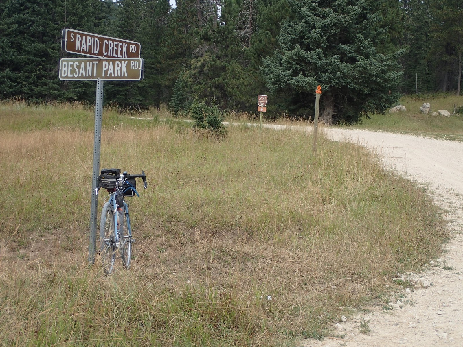
Another mile of climbing on O'Neil Pass Road leads to South Rapid Creek Road.  After the first few miles of vacation homes and retreats, the road narrows and enters more remote forests.  This is a most welcomed descent, after hours of climbing.  I had to stop at Besant Park Road for a moment.  This is where I had stopped, hard, at the Gold Rush Mother Lode, before Amy and Randall Smith of North Platte, Nebraska whizzed by, inspiring me to just beat the cut-off time at O'Neil Pass and eventually finish.  A moment worth remembering.  See Mother Lode Race Report

Black Fox Camp Road - primo Black Hills gravel.
The downhill scoot eventually ends at Black Fox Campground, where I turn right onto Black Fox Camp Road, USFS secondary road 233.  These five miles are a real treat - a barely developed, two track basically dirt road flows beside a mountain stream slowed by a series of beaver dams, with cliffs and rock formations above framing the valley.  Every pedal stroke was a photo opp.

Although Black Fox Camp Road was mostly uphill, too soon I turn off to continue to climb on Flag Mountain Road, secondary USFS road 189.  This road climbs up to and rolls along a ridge line, offering expansive views to the western horizon before cresting yet another ridge to showcase the monuments to the east - Harney Peak, Mt. Rushmore, Cathedral Spires and more.  After hours of riding through the thickly forested steeps of the Northern Hills, these big views seem even bigger.

The Montana wild fire haze hides most of the big peaks, but not the high plains below.
Here's where the wheels come off, or more accurately the air comes out.  On one of the fast descents on this rolling ridge line, my exuberance carries too much speed around a corner and onto a cattle guard.  Although I've crossed dozens of cattle guards that morning without incident, I hit this one too hard and too heavy.  I manage to stay upright, but the hiss of escaping air cut through my senses like an angry rattlesnake.

No problem.  A couple of minutes and I'll be flying down to Deerfield Lake for my planned lunch and water stop at the lakeside White Tail Campground.  I remove the spare tubes, tools and patch kit from the seat bag and reach for the pump in the top tube Tangle bag.  I find my turned-off cell phone, wallet, mud shank, spare batteries for the lights, spare map and no pump.  Ahhhhh.

With that sinking feeling in the gut, I remember removing that pump from the Tangle bag to carry in a CamelBack on my M-Hill mountain bike rides last week.  I had other pumps to use, but for some reason, I took that nicer one from the gravel bike and forgot to put it back.  I don't know how I didn't notice that when loading up the bike for this ride.

It doesn't matter.  This ride is over, until I find a pump that takes a Presta valve.  My cue sheets and odometer shout the bad news - almost 7 miles to the Mountain Meadows Resort.  Time to start walking.

A sad sight to see.  At least nothing is broken.