A border crossing into a near ghost town, miles of rolling county gravel through big ranch land, barely recognizable two-track through National Grasslands, and a rodeo town with one gas station, one bar, and one food truck. All in the first 48 miles of our through-ride of the BackBone Grande.
Right from the start, we launch right into a Great Divide vibe.
 |
| After a crossing a sea of grass, I'm grateful to see the "road" again in Buffalo Gap National Grasslands. (image by Paul Brasby) |
Since last autumn, I've been working on a new bikepacking route across South Dakota that I call the BackBone Grande. Drawing from years of exploring these back roads and from my ride of the Great Divide Mountain Bike Route, I strive to create a Great Divide type of experience right here in my backyard. All that time piecing together the route leaves open the big question. How does it ride as a through-ride?
Time to find out. And I have experienced help. Bikepacking buddy Paul Brasby of North Platte, Nebraska eagerly joins me. He's a strong, accomplished endurance cyclist and a great companion, as evidenced by our successful Cloud Peak 500 and Great Divide rides. With this ride essentially being a final recon of the BackBone Grande, I'm grateful for his willingness to ride the entire route with me and share his insights.
 |
| Paul Brasby pedaling out of Ardmore on Day 1 of our BackBone Grande. |
The BackBone Grande starts at the Nebraska border little more than a paved mile from the practically abandoned town of Ardmore. Less traffic seems to pass on the road than the adjacent train tracks.
The town itself dried up long ago after trains converted to diesel engines and no longer needed the stop for water. The scarce water accessible there proved to be too alkaline to sustain an agricultural economy and the town withered away.
Not surprisingly, no water is available here for the bikepacker, unless perhaps by knocking on the door of one of the few houses that may be occupied or by flagging down the occasional passing trucker or tourist.
 |
| Not far from Ardmore, the fog thickens. (photo by Paul Brasby) |
From Ardmore, the BackBone Grande turns east on Ardmore Road on solid county gravel through rolling ranch land, mostly private with sporadic patches of public land. This is part of Buffalo Gap National Grasslands, where dispersed camping is allowed. It's not well marked on site, however, so bring a good map if you plan to leave the public road.
On our first day, Paul and I ride directly into an unusual fog bank outside of Ardmore. Our sight lines dramatically shorten as the dark fog lingers well into the morning. So, no big views early on, but the cool temperatures and calm winds ease our crossing of this exposed prairie.
 |
| Wilcox Road heading east toward Buffalo Gap National Grasslands. |
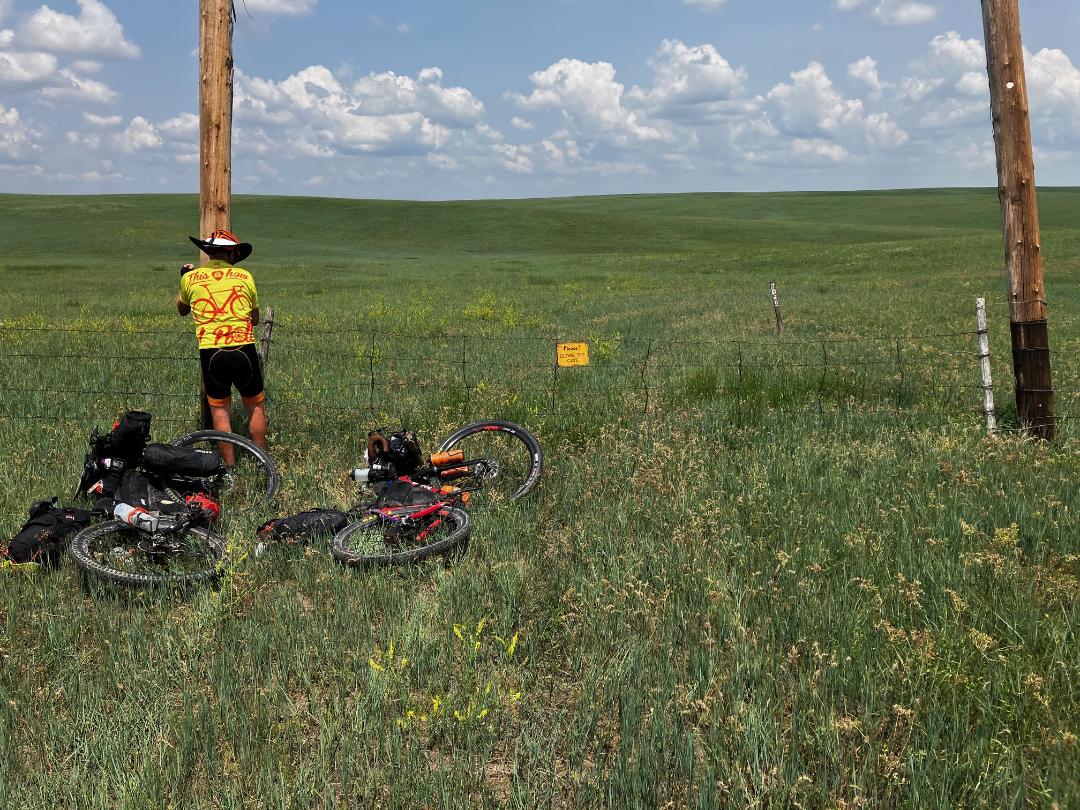
After about 30 miles of thoroughly enjoyable prairie gravel, we briefly turn onto paved Highway 79 to connect with Wilcox Road. This county gravel road passes by a "NO OUTLET" sign and then a couple of houses. Not to worry. Where we're going, we don't need "outlets."
Wilcox Road deteriorates rapidly after that and ends at a gated barbed wire fence. The marks the beginning of BGNG Road 7026, which the route follows for 14 miles through this next big chunk of Buffalo Gap National Grasslands. I drove this route in April 2023 and rode it in June 2023. Before that, I confirmed it with digital maps, paper maps, and conversation with rangers at the National Grasslands office in Wall. So, yes, this is a public road accessing public lands.
There are several gates along the way. Please close them. Some are easier than others.
 |
| The first gate off Wilcox Road. |
Once into Buffalo Gap National Grasslands and onto BGNG 7026, navigation gets real. During my recon drive of the route in April, I could clearly see many two-tracks. With signs few and far between, the challenge became choosing which one of the meandering two-tracks to follow. See, Buffalo Gap National Grasslands.
That was not an issue during our June through-ride. With incessant rain this spring, the two-tracks all but disappear into a sea of waving grass. Twice we follow what looks to be the road only to go "OFF ROUTE" on our GPS. Both times we work our way back on route with a little focus and diligence. Whether on route or off, we see nothing for miles but solid green.
 |
| Paul Brasby opens a gate in Buffalo Gap National Grasslands. The only hint of a road is the sign for BGNG Road 7026. |
Water is limited here, although cattle tanks appear along the route every few miles. All are empty in mid-June 2023, as they apparently have not yet been turned on. No matter. We carry enough water into this 14 mile stretch of remoteness, provided that we work our way out within a reasonable time.
Other than navigation, the biggest issue for us is pedaling on the uneven ground, softened by incessant rains, roughed up by cattle hoofs, and unseen through the grass. Nothing quite like soft and rough ground to deny a rhythm while demanding frequent, unpredictable bursts of power. Perhaps soon some rancher vehicle traffic will pound down and smooth out the "road." Today, it is a slow, arduous plod across the trackless prairie.
 |
| That much of a road is visible because I just rode over the grass. (image by Paul Brasby) |
 |
| This is the way. (image by Paul Brasby) |
The lack of a path and the soft, rough ground force us off the bikes on a couple of upward pitches. The resulting downhills aren't much of a break, as we work to keep bikes upright bouncing down on that same soft, rough surface, still unseen through the thick carpet of grass.
After almost two hours of plowing through the prairie, we crest a ridge to discover the makings of a road tracking along the somewhat rockier ridge line. Sight lines lengthen, the ground firms up and even smooths out a bit, and spirits soar.
Eventually, we fly by Limestone Butte Reservoir, a possible water source and dispersed camping site. After a few pictures, we roll on the suddenly good gravel road a couple of miles to paved U.S. Highway 18 and then a mile off-route into the rodeo town of Oelrichs. We work almost 4 hours to cover those 14 miles of Buffalo Gap National Grasslands. Now we're back in civilization and we're cooked.
 |
| Paul Brasby rides a ridgeline, with both a "road" and the distant Black Hills in sight. |
At first sight, Oelrichs doesn't appear to offer much, other than a spiffy rodeo arena. We spot a closed grocery store, a closed cafe, and a primitive "RV Campground," which is little more than an occasionally mowed empty lot with a few RV hookups. Maybe there's something at the gas station/C-store or the bar.
Then we spot a food truck. Yes, a food truck sits beside a vacant lot that someone calls the City Park. A local family started this business this spring and happens to be in Oelrichs for the evening. Score! I devour the Daily Special - a mammoth prime rib cheese steak with peppers and onions, a heaping mound of homemade potato salad, and a fully loaded Coke. All for the asking price of $12. Then I somehow find room for a homemade chocolate dessert. Amazing!
Seemingly half the town of Oelrichs shows up to check out the food truck and, of course, they all wonder about the two scruffy cyclists. But it's just small town curiosity, mixed in with the accustomed friendliness and generosity of people in the rural West.
What a day to start our ride of the BackBone Grande.
 |
| Oelrichs City Park featuring "Momma's Cookin'" food truck. (image by Paul Brasby) |
Thanks for posting! Looks like an interesting route. Cheers ... Guy
ReplyDelete