My January 2023 post "Introducing A Bikepacking Route" generated more page views on this blog than any other, including my Great Divide Mountain Bike Route posts. Now, two years later, it still does. And folks from all over continue to discover this route and imagine riding it.
So, here's my annual post linking to the
BackBone Grande Page, which describes the route in detail and links to posts sharing maps, images, logistics, and ride reports, including a series on the first through-ride by Paul Brasby and me in June 2023. Give that imagination a stir.
 |
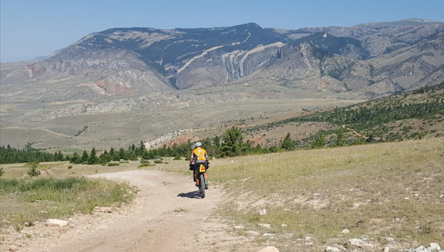
Streaming into the Black Hills from Custer State Park.
(image by Kevin Fox) |
In 2014, I created a bicycle route that I called the Black Hills BackBone, which is a North-South cross-state ride of the State of the South Dakota on primarily gravel and dirt roads along the spine of the Black Hills. The Black Hills BackBone blog first published in 2015 to document the route and attempts to ride it. In 2017, I created the DoubleBackBone route as an opportunity to ride the BackBone route south and then turn north to return to the North Dakota border on mostly different roads. I designed these routes as solo, self-supported, continuous rides across the state, in the spirit of the original TransIowa, the Gut Check 212, and similar continuous cross-state races.
See, Black Hills BackBone & DoubleBackBone Page.
Over the years since, I have ridden all those miles, and many more, in the Black Hills and surrounding prairie. I love exploring back roads unknown to me, creating interesting routes, and seeing routes created by others. If not riding, scouting, researching, or routing, I'm probably talking with someone about back country roads around here.
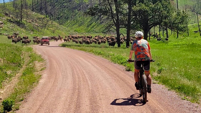 |
Traffic jam on Lame Johnny Road in Custer State Park.
(image by Paul Brasby) |
I started bikepacking in earnest in 2019, rode the Cloud Peak 500 in the Big Horn Mountains of Wyoming in 2020, and then rode the Great Divide Mountain Bike Route across the country in 2021. Those longer bikepacking rides are extensively covered on my blog throughout 2020-2022.
See, Cloud Peak 500 Page;
Great Divide Mountain Bike Route Page. Inspired by those rides, I created many multi-day bikepacking routes in the Black Hills, including five different one week trips for out-of-state friends, several 2-3 day trips, and many overnighters.
After completing the Great Divide in 2021 and learning of the current development of the Western Wildlands Route and the Great Plains Gravel Route, I took another look at my BackBone and DoubleBackBone. I still love those routes for their intended purpose, but they were not created for bikepacking. The Black Hills deserve such a route.
Here's my take on it. The Black Hills BackBone Grande.
 |
Mickelson Trail tunnel in the Central Black Hills.
(image by Paul Brasby) |
As a starting point, I consider bikepacking to be much more than simply blasting across the countryside to see how fast one can possibly cover a distance. Rather, for me, it's backpacking on a bike, taking the time and effort to absorb the local scenery, history, culture, and wildlife.
See, e.g., How I Would Bikepack The GDMBR (2019). As such, to create the BackBone Grande, I first identified what I consider the very best of our Black Hills and surrounding prairie and then connected things with a mix of unique, remote back roads. Here are some highlights:
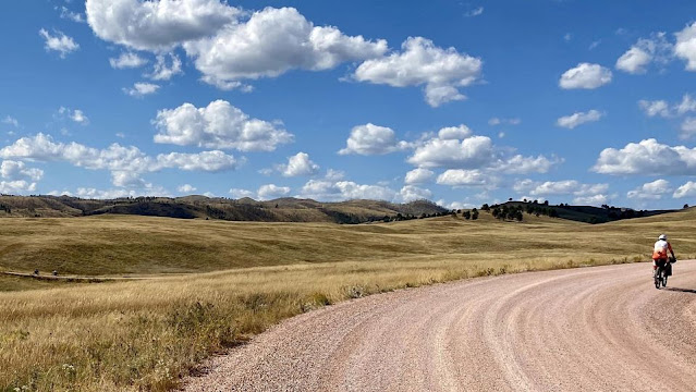
- Buffalo Gap National Grasslands, prairie with dispersed camping (miles 3-11; miles 32-77);
- Wind Cave National Park and Custer State Park with buffalo and wild burros (miles 102-124);
- Cathedral Spires views (miles 126-128);
- Mickelson Trail rails-to-trails path out of Custer, with views of Crazy Horse Memorial (miles 134-144);
- historic Gold Mountain Mine (mile 167);
- back on the Mickelson Trail for two hard rock tunnels (miles 174-178);
- creek side Castle Peak Road (miles 180-191), passing USFS Castle Peak Campground (mile 187);
- Black Fox Road (miles 202-207), passing USFS Black Fox Campground (mile 202);
- northern portion of Spearfish Canyon and Roughlock Falls (mile 234);
- Belle Fouche National Wildlife Refuge (miles 293-295);
- the Geographic Center of the United States (mile 323);
- the historic stage coach stop of Harding (mile 355);
- Custer Gallatin National Forest near the North Dakota border (miles 396-411), especially Fuller Pass Road passing USFS Picnic Springs Campground (mile 402).
 |
Abandoned road through Lost Canyon in the Northern Black Hills.
(image by Paul Brasby) |
In general, the BackBone Grande is about 420 miles long and almost 24,000 feet of gain, with 90% on county gravel or Forest Service gravel/dirt roads. It's a fun mix of remote roads, similar to those on the Great Divide Mountain Bike Route, all suitable for experienced bikepackers on loaded bicycles having tires 2" wide or more. A bike designed for the Great Divide, such as the Salsa CutThroat or Fargo, would work well for many. Of course, I rode the route in 2023 on my Jones 29+ rigid mountain bike with 2.35 inch tires.
Full service towns with bike shops are Custer (mile 135) and Spearfish (mile 262). C-store/restaurant type re-supply opportunities are at Oelrichs (mile 46), Buffalo Gap (mile 95), Blue Bell (mile 124), Hill City (mile 162), Rochford (mile 195), Cheyenne Crossing (mile 227), Savoy (mile 233), St. Onge (mile 281), and Buffalo (mile 382).
For a Great Divide type Zero Day, I recommend Custer and/or Hill City for an off-day, off-route ride of a mostly paved loop featuring Mount Rushmore, Sylvan Lake, Needles Highway, and Iron Mountain Road (aka Pig Tail Highway). For a relaxing Zero Day in a college/mountain bike town, enjoy a day in Spearfish.
 |
Fuller Pass Road through Custer Gallatin National Forest.
(image by Paul Brasby) |
 |
| Fuller Pass Road through Custer Gallatin National Forest, just a few miles from North Dakota. |
To create this route, I received valuable input from Lucas Haan of Black Hills Gravel and Paul Brasby of the Pony Express Bike-packing Adventure. To make this the very best it can be, Paul and I then rode the entire route in June of 2023, capturing images, taking notes, and making a few minor changes. In 2024, I also found an additional 30 miles of rugged two track through Buffalo Gap National Grasslands, bringing that section up to 45 memorable miles.
 |
| Barely marked roads in Buffalo Gap National Grasslands. |
 |
Immersed in the barely tracked Buffalo Gap National Grasslands.
(image by Paul Brasby) |
Note that the "Paved" surfaces data provided by RideWithGPS is wildly inaccurate, as it always is out here. The main route is about 90% county gravel or U.S. Forest Service gravel/dirt roads.
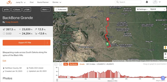 |
The Black Hills BackBone Grande.
|
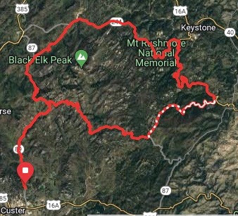 |
Optional off-route Mount Rushmore loop from Custer.
(46 miles/5,350 feet of gain) |
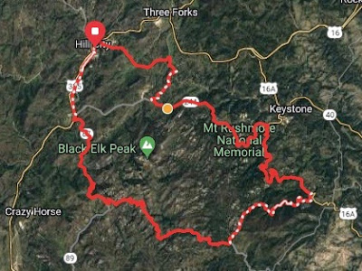 |
Optional off-route Mount Rushmore loop from Hill City.
(44 miles/4,900 feet of gain)
|
The Black Hills BackBone Grande.
A great ride on its own, and a great shake out ride for something bigger, like the Great Divide Mountain Bike Route.