Search This Blog

Showing posts with label Grande. Show all posts

Thursday, July 24, 2025

BackBone Grande Visual Tour (7) - Buffalo to North Dakota Border (miles 380-421)

Well, it's all right, riding around in the breeze
Well, it's all right, if you live the life you please
Well, it's all right, even if the sun don't shine
Well, it's all right, we're going to the end of the line.

End Of The Line, Bob Dylan, George Harrison, Jeff Lynne, Roy Orbison, Tom Petty (1989).


The BackBone Grande is my 420+ mile backroad bikepacking route across the State of South Dakota along the spine of the Black Hills and through the surrounding prairie. Inspired by my experience riding the Great Divide Mountain Bike Route, I designed it to create that type of experience here in my back yard. Tracking rough roads that showcase the best of our scenery, history, culture, and wildlife, the BackBone Grande is a great ride on its own and as a shakedown for the GDMBR.  For a collection of my stories all about it, go the BackBone Grande Page.

For those more visual learners, I've selected images along the route from various scouting trips, the first through-ride, and other rides. Here is my seventh installment of the BackBone Grande Visual Tour, from the town of Buffalo to the North Dakota border (miles 380-421). 


From the cowboy town of Buffalo, the BackBone Grande continues to streak across the Northern Prairie on solid county gravel past large cattle ranches. Then, with the North Dakota border practically within sight, a fun Low Standard Road climbs to a forested, lumpy oasis in the midst of millions of acres of grassland. It's a lonely outcropping of Custer Gallatin National Forest, with the surprising Picnic Springs Campground waiting on top. 

This isn't part of the Black Hills, but rather a farewell gift of a final, backcountry gem before the border.

It's the end of the line. And it's all right.


Here's a photo gallery of the BackBone Grande route from the town of Buffalo to the North Dakota border (miles 380-421). Also, here are links to prior blog posts about this section. BackBone Grande Introduction - Oasis in the Northern PrairieBackBone Grande Through-Ride - Grand Finale.


Rolling out of Buffalo on Lyons Road (Old Highway 85).
(image by Paul Brasby)

Further east on Lyons Road.
(image by Paul Brasby)

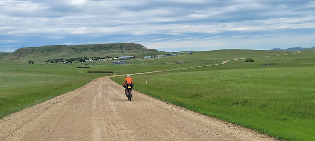
Turning north on Brown-Johnson Road.
(image by Paul Brasby)

Approaching a big ranch on Brown-Johnson Road.
(image by Paul Brasby)

Wily fox surveys from a unique vantage point.
(image by Paul Brasby)

Pondering the journey ahead on South Cave Road.
(image by Paul Brasby)

South Cave Road looks to be climbing toward some hills.
(image by Paul Brasby)

Surprising evergreen-topped lumps ahead along Tufte Road.
What's that doing out here?

Tufte Road starts to climb up that valley.
(image by Paul Brasby)

Climbing in earnest on Tufte Road.
(image by Paul Brasby)

Turning off Tufte Road onto USFS Low Standard Road 3123.
(image by Paul Brasby)

Another sweeping switchback on Road 3123.
(image by Paul Brasby)

Topping out.
(image by Paul Brasby)

Another curve leads to another pitch.
(image by Paul Brasby)

It's not flat on top.

Still rolling around on Road 3123.

Road 3123.
(image by Paul Brasby)

Approaching Fuller Pass.

A view from USFS Picnic Springs Campground in Custer Gallatin National Forest.
It feels like you're back in the Black Hills.

No reservation, no fee, first-come-first-served USFS campground, with 9 sites and 2 group sites.
Spring water, picnic tables, fire pits, and vault toilets.

Looking back toward Buffalo from Picnic Springs Campground.
(image by Paul Brasby)

Cresting Fuller Pass on Road 3123.
(image by Paul Brasby)

Time to descend.

Fuller Pass Road, USFS Low Standard Road 4113.

Dropping back onto the prairie on Fuller Pass Road.
(image by Paul Brasby)

Final stretch to the border on Rhame Road.
(image by Paul Brasby)

Mile 0. The border between South Dakota and North Dakota.

End of the line.
(image by Paul Brasby)


End Of The Line, Traveling Wilburys (1989).


Saturday, May 3, 2025

Black Hills BackBone Grande - Invitation & Offer

The BackBone Grande is a unique 400 mile bikepacking route across the State of South Dakota along the spine of the Black Hills. I designed this route specifically for a Great Divide type of bikepacking experience that showcases the best of our Black Hills and surrounding prairie. For a series of posts introducing this route, including a digital map, and a series of posts of the first through-ride go to Black Hills Grande Page.

If you have any questions, ask. If you're thinking of venturing out here, let me know. I'm happy to help.

Here's an offer. Ride the BackBone Grande, any or all of it, and send me a picture and story. I'll send you a BackBone Grande sticker.

As others have noted, it doesn't say "Black Hills," or anything about bikepacking, or even cycling.

Nope. If you know, you know.

Here's the sticker.

Here's the sticker in the wild.

Even in a crowd, the BackBone Grande sticker stands out.


Thursday, April 10, 2025

BackBone Buffet Update - It Gets Better

I'm going up the rough side of the mountain on my way home, meet my people (Trying to get home)
I'm going up the rough side of the mountain on my way home, oh yeah (Trying to get home)
I'm going (Climbing)
Up the rough side of the mountain (Climbing)
Oh, Jesus (Climbing)
On my way (Climbing)

Climbing Higher Mountains, Traditional.

Contrary to the sign, USFS 818.1A is not a "DEAD END" for those on a bicycle.

Last month I introduced the BackBone Buffet, my new rough road bikepacking route showcasing the best of the Central Black Hills of South Dakota. I've ridden all the roads on the route, although not in one ride put together this way. I look forward to bikepacking it this summer. See, Introducing The BackBone Buffet.

Starting the climb up to Elk Mountain Lookout Tower on USFS Low Standard Road 818.1A.

The BackBone Buffet started with the idea of creating an easily accessible 4-5 day rough road bikepacking loop smack in the middle of the Black Hills. With all my riding, scouting, and routing throughout that area over the years, I decided not to start from scratch, but rather cherry-pick favorite sections of my original BackBone, DoubleBackBone, BackBone Grande, BackBone DoubleGrande (not yet released) and even some Black Hills Bounty roads and combine them in a single 200 mile loop out of Hill City.

Those existing routes occasionally intersect, e.g., the original BackBone and the BackBone Grande meet on Black Fox Camp Road, but connecting the chosen sections often required some distance of different roads. Eventually, I fashioned together and published the loop. BackBone Buffet - RideWithGPS Map.

Looking back on the climb up USFS Low Standard Road 818.1A.

Analyzing those new connectors more closely over time and coffee, I unearthed a couple of areas to improve. For example, I did not particularly like the connection from the bottom of Red Bird Canyon (about Mile 103) to Dewey Road (USFS Primary Road 769) (about Mile 108) and beyond. That stretch required over 5 miles on paved U.S. Highway 16, followed by more miles on highly developed Dewey Road before finally reaching some primo Bounty roads to McKenna Spring. There must be a better way.

So, from USFS paper maps and RideWithGPS satellite images, I pieced together a possible re-route that turned off U.S. Highway 16 a couple of miles short of Dewey Road onto an unnumbered, double-dashed, apparently abandoned "Road Closed Yearlong To Motorized Traffic." After about a mile, that "road" t-boned into USFS Low Standard Road 818.1A for a suck-it-up steep pitch to a fire lookout tower and then a gradual descent over to Dewey Road. What's not to love about that! 

It looked to be an awesome add to the BackBone Buffet, and possibly to the BackBone DoubleGrande, if that first mile of abandoned "road" is public. However, I could not determine that from home, since it was not clearly labeled and passed through private land. Time for a road trip.

Elk Mountain Lookout Tower, with 360 degree views from the top.

Score! That little unnumbered, double-dashed "road" is a public road that actually does connect with USFS Low Standard Road 818.1A. It is closed to motorized vehicles yearlong, but is always open for travel by foot, horse, and bicycle. Sweet!

Know that it's not easy. From the paved highway, the route climbs over 700 feet in the first 2 miles and another 400 feet in the next 2.5 miles, with at least one pitch of 19% (according to RideWithGPS). But the 360 degree views from atop the lookout tower are breathtaking, as are the sharp elevation drop views along the relatively long, gradual descent.

Uffda! 

Absolutely I added it to both the BackBone Buffet and the BackBone DoubleGrande.

So, for anyone riding any of my routes, check the RideWithGPS file for the latest update. 

I'm always looking for the best.

Updated BackBone Buffet map on RideWithGPS, showing the climb up Elk Mountain Lookout Tower.
The new section leaves U.S. 16 to climb to the tower and then descend to Dewey Road.

Same map as above, but in "Google Terrain" mode to show relief. Would you look at that!


Climbing Higher Mountains, Aretha Franklin (1972).


Thursday, February 27, 2025

BackBone BreakOut (90 Miles)

Castle Peak Road (USFS Low Standard 181).

The BackBone BreakOut.

A 90 mile rough road overnight bikepacking loop starting and ending in Hill City.

Nothing like an overnighter to get started.

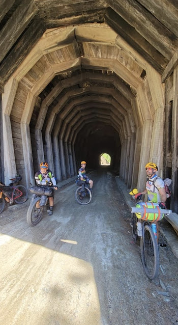
Mickelson Trail tunnel.
(image by Paul Brasby)

From charming Hill City, the BackBone Overnighter explores about 80 miles of rough, remote USFS back roads and almost 10 miles of rails-to-trails Mickelson Trail for a two day tour showcasing the best of the Central Black Hills of South Dakota.

This forested, hilly loop passes a restored, abandoned gold mine, crosses over a trestle, eeks through old railroad tunnels, follows trout-filled streams, sidesteps to the iconic Moonshine Gulch Saloon, climbs along a beaver damned creek to an abandoned stone lookout, and meanders up and down back roads through prime elk country back to Hill City. An experiential Black Hills feast.

About 40 miles into the 90 mile loop awaits idyllic USFS Black Fox primitive campground, a sweet spot to spend the evening. Of course, one may choose to disperse camp throughout much of the Black Hills National Forest. In particular, one may wish to gradually climb another 12 miles past Black Fox to camp atop Flag Mountain by the lookout tower. 

Black Fox Camp Road (USFS Secondary 233).

This is a gravel and dirt road route, with about a mile of mellow single track, covering about 90 miles and 7,400 feet of elevation gain over 2 days. Several sections can be rocky, rutted, loose, and/or muddy, such as Horse Creek Road, Castle Peak Road, the spur up Flag Mountain, Williams Draw Road, and a few unnamed connectors. Stretches of this route have earned their way onto parts of the Black Hills BackBone, the Black Hills Bounty, the DED Dirt Ride, several Black Hills Gravel Series rides, and even the BackBone Grande. If you only have two days, here's a choice taste of bikepacking the Black Hills.

When loaded for an overnighter on this route, I prefer a bike with 2 inch or wider tires. When riding it loaded on soft roads in late May a few years ago, I comfortably rode my Jones 29+ with 2.35 inch Bontrager XR2 tires. On the other hand, I have comfortably ridden this entire route on my single speed Black Mountain MonsterCross with 40 mm tires, but that was a single day ride. Loaded, I'd go wider.

The lookout atop Flag Mountain.

Surface water to filter is widely available along the route. Potable water is available at the Mystic Trailhead of the Mickelson Trail (mile 16.5 of Day 1), at the Moonshine Gulch Saloon, the Rochford Small of America, and the Mickelson Trailhead in Rochford (mile 32.5 of Day 1), and at the USFS White Tail Campground (mile 19.2 of Day 2). The Moonshine Gulch Saloon also offers bar food and drinks, while the Rochford Mall sells light snacks.

Located an easy 26 miles from Rapid City, Hill City is a thriving tourist town of about 1,000 residents. It offers a variety of shops and art galleries, motels and campgrounds, and restaurants and bars. Hill City is also minutes away from Mt. Rushmore National Monument, Crazy Horse Memorial, and the granite towers of Cathedral Spires along Needles Highway. The Heart of the Hills is an ideal place to launch a Black Hills adventure.

Turning off Williams Draw Road (USFS Secondary 691) onto USFS Low Standard Road 301.1R.

For an alternative experience with shorter riding days, one could make a 3 day/2 night trip by riding 26 miles to camp at USFS Castle Peak Campground on Day 1, ride 33 miles to camp at USFS White Tail Campground on Day 2, and ride 31 miles to finish on Day 3. Of course, one could also go the other way, ditch the camping altogether, and ride the entire 90 miles loop in a single day.

This route is publicly available on RideWithGPS at BackBone BreakOut


Thursday, January 30, 2025

What's The Difference - BackBone, DoubleBackBone & BackBone Grande

Folks regularly ask about the differences between my Black Hills BackBone, DoubleBackBone, and BackBone Grande routes. Here's an overview that describes the genesis, formation, and development of these three routes and how they differ. 

My introduction of the Black Hills BackBone Grande route in 2023 prompted many questions about the differences from my older Black Hills BackBone and DoubleBackBone routes. Fair enough. 

BackBone & DoubleBackBone = designed for long gravel rides, but can bikepack it. 
The BackBone Grande = designed for multi-day bikepacking, but can continuous ride it.

Of course, there's much more to that story. The BackBone Grande draws from a deeper data base built from 10 additional years of back roads exploration in the Black Hills and the unforgettable experiences of multi-day and multi-week bikepacking rides across the Mountain West. It takes cyclists to more memorable places, both well-known and obscure, on a wider variety of challenging roads. It's a different beast.

If you're looking for USFS Low Standard Roads, the Black Hills are full of them.
The Black Hills are beautiful. Most any combination of roads winding through the Black Hills will be a beautiful ride. But there is a difference between better and best. The BackBone Grande covers what I consider to be the very best of our Black Hills and surrounding prairie in a cross-state bikepacking ride.

USFS Secondary Road 189 southbound down Flag Mountain.
The signature image of the Black Hills BackBone.
Back in 2014, I created the BackBone as a solo, self-supported, light and fast gravel ride. At 310 miles and 19,700 feet of elevation gain, it certainly pushes the limits of a long, continuous ride for most cyclists. But with straight forward navigation, 200 miles of Primary Roads, and 35 miles of pavement, the BackBone rides relatively fast. Low Standard Roads, the rough ones that really take it out of you and take you further out there, account for just 7 miles, or about 2%, of the BackBone.

In 2017, I then created the DoubleBackBone as an opportunity to ride the BackBone southbound and then return to North Dakota on mostly different roads. The DoubleBackBone runs generally to the West of the BackBone, so it's even more remote, with less re-supply opportunities and less cell coverage.

The overall road makeup of the DoubleBackBone is much the same as the BackBone. At 330 miles and 17,900 feet of elevation gain, it similarly rides relatively fast, with straight forward navigation, 238 miles of Primary Roads, and 38 miles of pavement. Low Standard Roads are less than 16 miles, or about 6%, of the DoubleBackBone.

Mostly on well developed gravel roads, the BackBone and DoubleBackBone are certainly suitable for loaded touring, if that's your jam. That's just not why they were created. 

USFS Low Standard Road 383 northbound to Gillette Canyon.
The signature image of the Black Hills DoubleBackBone.
After bikepacking throughout the Black Hills and across the Mountain West the past several years, I decided to design a new route specifically for a Great Divide type of bikepacking experience. For me, that means 50-100 mile days on a loaded mountain bike over back roads with significant climbing, more navigational challenges, more miles of rougher roads, more little known and even abandoned roads, a mix of re-supply and sleeping options, more natural and human-made sightseeing, both well known and obscure, and a few fun Zero Day opportunities. A much different experience.

The BackBone Grande is my take on that type of bikepacking route, featuring many miles of rougher roads with popular sights and little known gems along the way. This route will take you to many places the BackBone and DoubleBackBone do not. Those that have ridden the Great Divide or my Black Hills Bounty routes will catch a similar vibe on the BackBone Grande.

Like the Great Divide, it's not all back country. For a short break during this relatively remote bikepacking ride, I added some pavement across the college town of Spearfish to pass both bike shops, an assortment of restaurant and re-supply options, and lodging, including the popular city campground. Likewise, I skirted Custer to provide easy access to that popular tourist town with similar amenities. From Custer and from Hill City, I also added optional, off-route, mostly paved loops to Mount Rushmore, Sylvan Lake, Needles Highway, and Iron Mountain Road for a scenic, more conventional tourist day. No sense rushing a vacation. In 2024, I added the Mount Rushmore Alternative route from Custer to Hill City for those not wanting a Zero Day. I also added a short bypass of the notorious Trail #1 in Custer State Park. All of these maps are available as RideWithGPS files at my BackBone Grande Collection.

Lame Johnny Road westbound into the Black Hills.
The signature image of the Black Hills BackBone Grande.
(image by Kevin Fox)
At a touring pace of 60-70 miles per day, a bikepacker will ride 6-7 days to complete the 421 mile BackBone Grande, plus another day for an optional Mount Rushmore loop. Some will certainly ride it faster. Others may even attempt to through-ride it, although I don't recommend it. This is one to soak in. Besides, who wants to T-bone a large mammal at night while settled in aerobars and staring bleary-eyed at a power meter.

The BackBone Grande is a remote, rough road route for self-sufficient, experienced bikepackers capable of successfully riding through sparsely populated backcountry with spotty, if any, cell coverage. You're on your own out there. Enjoy it.

USFS Low Standard Road 530.1A.
A piece of the 58 miles of Low Standard Roads on the BackBone Grande.
Here is an approximate breakdown of the roads on the BackBone, DoubleBackBone, and BackBone Grande. Perhaps the most simple comparison of these routes is the total miles of Low Standard roads. BackBone = 7 miles. DoubleBackBone = 16 miles. BackBone Grande = 87 miles. Another comparison adds the Low Standard and Secondary roads. Backbone = 75 miles. DoubleBackBone = 44 miles. BackBone Grande = 167 miles. The Grande is a different beast.

For a description of Primary, Secondary, and Low Standard roads in the Black Hills, go to my post. The Good, The Bad & The Ugly.

BackBone - 310 miles/19,700 feet gain (BackBone Map)
65% - Primary (200 miles)
22% - Secondary (68 miles)
11% - Paved (35 miles)
2% - Low Standard (7 miles)
0% - Single Track (0 miles)

DoubleBackBone - 330 miles/17,900 feet gain (DoubleBackBone Map)
72% - Primary (238 miles)
11% - Secondary (38 miles)
11% - Paved (38 miles)
6% - Low Standard (16 miles)
0% - Single Track (0 miles)

BackBone Grande - 421 miles/23,800 feet gain (BackBone Grande Map)
49% - Primary (205 miles)
19% - Secondary (80 miles) 
11% - Paved (48 miles)
21% - Low Standard (87 miles)
< 1% - Single Track (1 mile)

For more information on each route and links to posts with images, ride reports, and stories, go to the Black Hills BackBone and DoubleBackBone Page and the BackBone Grande Page. Happy trails.