Rocky Mountain Way, Joey Vitale, Joe Walsh, Ken Passarelli & Rocke Grave (1973).
Out there, on the Great Divide Mountain Bike Route. (image by Paul Brasby)
In late summer 2021, I rode the Great Divide Mountain Bike Route self-supported from the Canadian border at Roosville, Montana to the Mexican border at Antelope Wells, New Mexico. It was an amazing, unforgettable experience. I'll always cherish that overwhelming feeling of pure joy and utter disbelief at the finish. That is why to dream audaciously, set goals boldly, and work relentlessly to achieve.
After riding 7 weeks on the Great Divide, I spent the next 7 months writing about it. Over the Fall and Winter of 2021, and well into the Spring of 2022, I published 50 blog posts about my experience. Stories of individual happenings or days flowed easily, but expressing the overall experience proved difficult. I know that I still have not adequately covered it.
Nonetheless, to this day, I still see traffic on many of these posts. Now, with the New Year, I know that folks are preparing for their own ride of the Great Divide this summer and are looking for information and encouragement. So, I'm bumping a post from last year when I made those Great Divide posts easier to find by creating a separate Page just for them.
On the right side of the main Black Hills BackBone blog, look for the section called "Pages." There is one called "Great Divide Mountain Bike Route (2021)." On that Page, you will find links to my Great Divide blog posts on a variety of subjects, including preparations, gear lists, packing, bike set-up, logistics, navigation, food, encounters with others, adaptations, and the all important mental aspect. Photographs adorn each post. There's even a slide show with one representative image for each day and an entire Gallery of amazing Paul Brasby images.
If you plan to ride the Great Divide, or you just want to read along with my ride, it's a place to start.
Rocky Mountain Way, Joe Walsh (1973).
Rocky Mountain Way, Joe Walsh (live at Santa Monica Civic Auditorium 1976).
The way back to town is only 70 miles. If you save your breath, I feel a man like you can manage it.
Blondie encouraging Tuco, The Good, The Bad & The Ugly (1966).
The United States Forest Service (USFS) categorizes the roads within its boundaries as "Primary Routes," "Secondary Routes," or "Low Standard Routes." That's it. Just three categories for the staggering variety of roads in our national forests.
Well, it's a start. Here's a USFS graphic introducing each category of Forest Service roads.
As an introduction to understanding these categories of roads in the Black Hills National Forest, here are some of my general observations, with representative photographs. Whatever the USFS calls them and however I describe them, every road in the Black Hills will deliver a variety of riding conditions and challenges that change over time. Your eyes on the road and tires on the ground are the best way to know these roads.
Note that the USFS manages extensive logging operations in selected parts of the Black Hills. In large part, that's why most of these roads exist. Yield to all traffic out there, but especially the big logging trucks. And be thankful to be able to ride on the seemingly unlimited roads resulting from their work.
The Good (USFS Primary Route)
The most developed non-paved road in the USFS system is the Primary Route, which is designed, built, and maintained for year around, regular travel by standard passenger cars. In the Black Hills, the surface of these roads typically is moderately graveled, hard packed local dirt and limestone that drains water well, and generally does not instantly clog, at least not like Iowa top soil, Nebraska talc, or Oklahoma clay. Some roads are treated with Magnesium Chloride, which hardens and stabilizes the surface.
Primary Routes generally are wide enough for opposing motorized traffic to pass easily. If enough gravel exists to form tracks, there would be three or even four. Often a small shoulder will accumulate a bit more gravel that has been pushed off to the side. Relatively high speed vehicle traffic may create washboards and pockets of loose gravel in spots, especially around curves and corners.
My ride of choice for Primary Routes is my Alchemy Ronin Titanium gravel bike or my Black Mountain Cycles Monster Cross bike, set up with 40 mm Schwalbe G-One tires. Even when loaded for multi-day bikepacking, these gravel bikes provide plenty of support and control to comfortably ride all day on these roads. Relatively speaking, Primary Routes are fast.
On USFS maps and signage, a Primary Route is designated by brown sign with a two or three digit number enclosed in a rounded corner, isosceles trapezoid having the longer parallel side on top, as shown below for Boles Canyon Road (117).
The following photographs are representative of USFS Primary Routes in the Black Hills.
The Bad (USFS Secondary Route)
The next level of developed, non-paved roads in the USFS system is the Secondary Route, which is maintained for high clearance vehicles. In the Black Hills, USFS Secondary Routes typically are similar in composition to Primary Routes, that is, hard packed dirt and limestone that handles water well and does not overly clog. However, the surface may be even less graveled, or just occasionally graveled, or not graveled at all. Almost certainly, it will not be treated with Magnesium Chloride. Foremost, that means Secondary Routes are more susceptible to mud when wet and ruts when dry.
Due to less maintenance, Secondary Routes also sport occasional loose dirt, exposed surface rock, pot holes, standing water, and fallen timber, while presenting sharper turns, steeper gradients, and shorter sight lines. Also, Secondary Routes typically are two tracks wide, often with little to no shoulder. If a motorized vehicle approaches, I typically pull off the road to allow it to pass. For logging trucks, I definitely leave the road.
All that being said, many Secondary Routes in the Black Hills are passable in dry conditions in passenger cars, if attentive to occasional obstacles and clearance issues. For example, In 2017, I confirmed new cue sheets for the slightly modified Black Hills BackBone route driving my 2006 Chevrolet HHR, hardly a high clearance vehicle. Over the 310 mile route, with many miles of Secondary Routes, I maneuvered around a few high-center issues and only had to skirt one fallen tree blocking the road. These roads can be fast, so stay alert.
My ride of choice for most Black Hills Secondary Routes is still one of my gravel bikes with 40 mm tires. These roads may be rougher and mountain bike type gearing may be helpful in spots, but most of these roads are developed enough for me on a gravel bike. On the other hand, if loaded for a multi-day ride with significant miles of Secondary Routes, I may well opt for my Jones 29+ mountain bike with bigger tires.
On USFS maps and signage, a Secondary Route is designated by a three or four digit number enclosed in a brown, rounded corner rectangular sign, as shown below for Williams Draw Road (691).
The following photographs show three USFS Secondary Routes in the Black Hills.
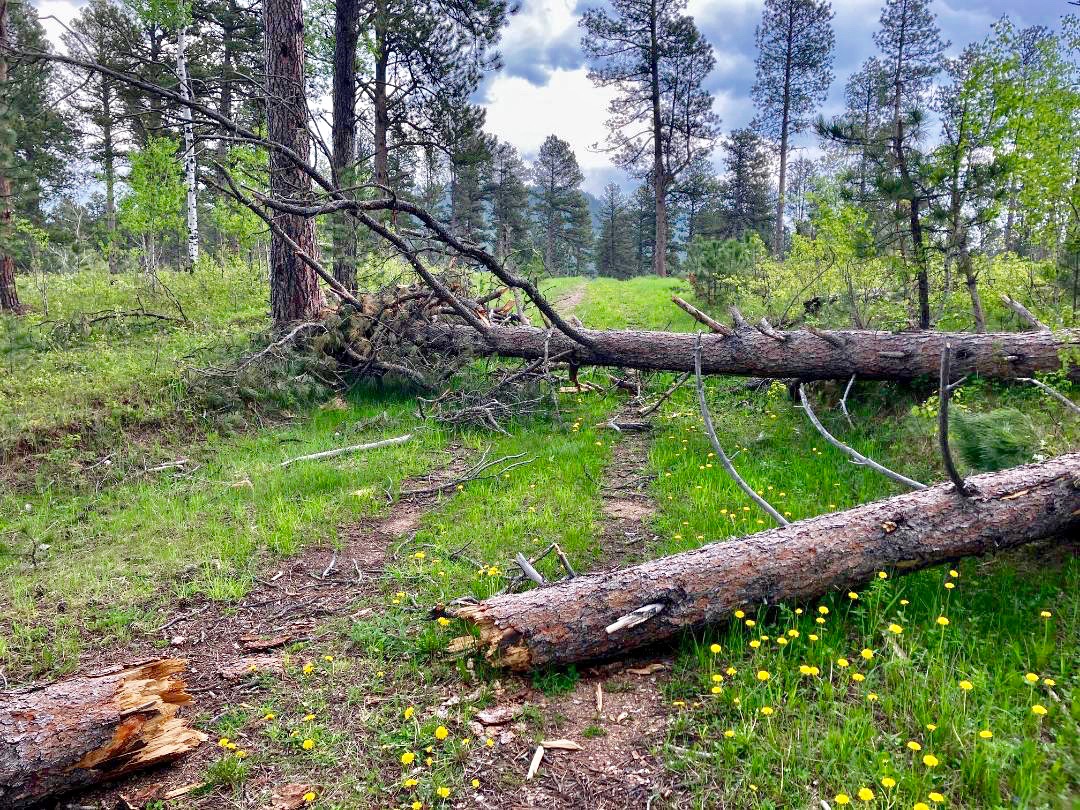
The Ugly (USFS Low Standard Route)
The third level of developed, non-paved road in the USFS system is the Low Standard Route, which is unimproved and not maintained for automobiles. The Forest Service recommends travel by vehicles with both high clearance and four wheel drive. I would add driver experience and prudence.
Design, construction, and maintenance of Low Standard Routes are all over the map, even along a single numbered road. Some sections may be soft dirt, while others are rock gardens. If wet, standing water and mud can be a real issue, leaving deep ruts when dry. Maybe a load of chunky rock was dumped to stabilize a low spot, or maybe not and there's a stream to ford. They are rough, sometimes little more than a bull dozed logging trail. For me, this is mountain bike territory, for tires and gears, even unloaded, for anything more than a short connector.
Many, many, many Low Standard Routes are dead-end spurs that were built to get to a spot for logging. Maybe some spurs later connect to something else and haven't made it on a map, or maybe not. I often refer to the USFS Motorized Vehicle Use Maps, which are updated every year and prove to be pretty accurate. However you navigate, count on no cell coverage and no passing traffic of any kind. You are on your own.
If you like this kind of riding, the Black Hills offer a lifetime of miles to explore.
On USFS signage, a Low Standard Route is designated with a three-digit number vertically imprinted on short, 4 inch wide, brown carbonite post. On USFS maps, it's just a plain three-digit number. The designation of any road emanating from that Low Standard Route adds a decimal and another number. For example, in the Black Hills, USFS 278.1 runs off of USFS 278. Then, any roads running off of USFS 278.1 get letters, the first being USFS 278.1A, then 278.1B, and so on. It can be confusing in the field and USFS map navigation is an entirely separate subject. Just know that any carbonite USFS road sign with a three-digit number, or with decimal numbers, or with letters, identifies a Low Standard Route.
Shown below is a sign for Low Standard Route 242, and then one for Low Standard Route 325.1D.
The following photographs show a sampling of USFS Low Standard Routes in the Black Hills. I captured all of these images while out riding, with the sole exception of the last photograph, which Lucas Haan provided as an example of a deposit of chunky gravel. I included more photographs of Low Standard Routes because of their great variety.
To wrap this up, here's a fun rendition of Ennio Morricone's 1966 composition of music for the movie "The Good, The Bad And The Ugly," performed by the Danish National Symphony Orchestra in 2018.
The Good, The Bad And The Ugly, Danish National Symphony Orchestra (2018)