Search This Blog

Sunday, May 28, 2023

BackBone Grande (Miles 203-272) - Northern Black Hills and Beyond

The BackBone Grande is a 400 mile bikepacking route running south to north across the State of South Dakota along the spine of the Black Hills. It's a highlight reel showcasing the best of the Black Hills and surrounding prairie, connected by a unique mix of remote gravel and dirt roads. It's a Great Divide type of bikepacking experience right here in my backyard. See, Introducing The BackBone Grande.

At Mile 203 of the BackBone Grande, Cheyenne Crossing sits high in the Northern Black Hills, a long time mining area and now popular year round recreational area for both human and machine powered activities. Over the years, countless mining claims and all kinds of residential properties created a byzantine patchwork of private and public land. The route weaves down Forest Service roads through these lands, passing Roughlock Falls, Forest Service campgrounds, and hiking/mountain biking trailheads. Further downhill lies the college/mountain bike town of Spearfish and then the Belle Fouche National Wildlife Refuge. The Northern Black Hills are a fitting finish to the Black Hills portion of the ride.

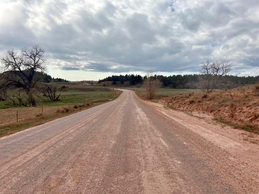
Entering Spearfish Canyon shortly after Cheyenne Crossing.

From Cheyenne Crossing, the BackBone Grande winds along Spearfish Creek down to Savoy, another ghost town survived by a cafe and resort. The route then gently climbs up Roughlock Falls Road (USFS Secondary 222) to, yes, Roughlock Falls, a popular tourist and picnicking area. That's a nice spot for a break to stretch legs a bit with a stroll to the falls. Further up the well-traveled gravel road is USFS Rod and Gun Campground and then USFS Timon Campground for those looking for a developed campground with potable water, picnic tables, and bathrooms.

Then it's on to Schoolhouse Gulch Road and Beaver Creek Road for a meandering 9 miles. It's easy to fly down these roads, but know that a hilly mile off route is Iron Creek Lake, yet another mountain resort area with some re-supply opportunities. Shortly thereafter, the route turns onto less traveled Higgins Gulch Road (USFS Secondary 214) for a long, gradual descent past Crow Peak Trailhead into Spearfish.

Scenic, though chronically pot-holed, Roughlock Falls Road (USFS 222).

The BackBone Grande enters Spearfish from the NorthWest, traverses much of the retail parts of town, and finally exits from the SouthEast. As the largest town on this entire route, Spearfish offers grocery stores, C-stores, fast food, restaurants, bars, micro-breweries, and two full service bike shops. 

To more easily access all these re-supply opportunities, the BackBone Grande takes a route directly on the town's commercial strips, intentionally riding by both bike shops:  Rushmore Bikes at 3105 West Fairground Loop and Two Wheeler Dealer at 305 North Main Street. That sounds like a lot of traffic, but it's Spearfish, a town of about 12,000 people. It's just not that busy. And there are bike paths and sidewalks, if the road is too much. 

(For just one comparison, the Great Divide Mountain Bike Route takes a similar, much longer NW to SE route through most of Butte, Montana, population 34,500).

USFS Timon Campground, on Roughlock Falls Road (USFS 222).

A bit south of downtown, the City of Spearfish operates a campground along Spearfish Creek next to Spearfish City Park descriptively named The Spearfish City Campground. Notwithstanding the vanilla name, the City Campground is popular with campers of all kinds and a great spot for a Zero Day. It's also near the start of the Dakota Five-O mountain bike race, a Labor Day fixture for the mountain bikers around here. 

The route continues past more retail and crosses Interstate 90. But this is still a small town. Pavement turns to gravel less a half mile past a Wal-Mart parking lot. Soon, the route turns onto Lookout Mountain Road, a Minimum Maintenance Road that is regularly deeply rutted. Hope that it's not muddy. It's time to roll some county gravel out into the country.

Lookout Mountain Road. Believe the sign.

Now, we're bumping along some rolling hills through residential acreages and out into ranch land. At Mile 258, the BackBone Grande spins through St. Onge, a town best known for its cattle auctions and bar. Then it's out on Sale Barn Road, a short Minimum Maintenance Road that is chronically muddy. 

A twisty spin through scrub oak on Crooked Oaks Road rolls past historic Snoma Finnish Cemetery and then the town of Fruitdale (no commercial establishment). A bit of pavement tops out at the Belle Fouche Reservoir, home of the Bell Fouche National Wildlife Refuge. Developed campsites are available there at the Rocky Point Recreational Area.

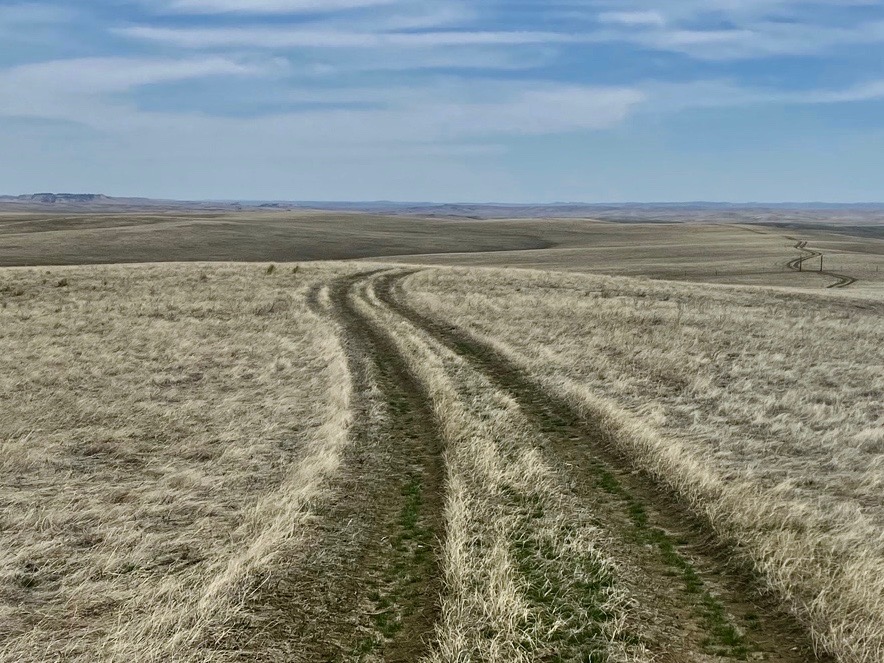
Unnumbered, unnamed, sometimes-two-tracks-are-visible connector to Old Baldy Road.

That's it? No Low Standard Roads? No nameless two track? For an entire 70 mile stretch of the BackBone Grande? Well, I may have skipped one or two.

Back on about Mile 217, the BackBone Grande turns north off Schoolhouse Gulch Road (USFS 222) onto a solid Secondary Road for about a half mile. The route then turns sharply left onto a rough, unnumbered two track. Pay attention here. The two track follows an old road bed, but occasionally disappears to one track, or even no track in spots. But I've ridden it. It connects with Old Baldy Road (USFS Low Standard 633.1) in a couple of miles and then back to Schoolhouse Gulch Road near Beaver Crossing. This little shortcut spices up this section, adds a couple of cascading streams through a small canyon, and offers some primo disperse camping opportunities.

Another Low Standard Road/nameless two track combo takes off Higgins Gulch Road just after Iron Creek Lake at about Mile 222. More specifically, USFS Low Standard Road 130.1 winds for a delightful 5 miles along a high ridge through aspen groves before turning onto another unnumbered, unnamed two track connector for a couple of miles, mostly downhill back to Higgins Gulch Road. This deeper dive into the Black Hills promises to add splashes of amazing colors in the summer and autumn.

Really nice USFS Low Standard Road 130.1 through aspen groves.

Other Low Standard/nameless two track connectors are always possible, with our virtually unlimited roads and near roads throughout the Black Hills. I regularly stumble across new finds, so always check the RideWithGPS file to ensure you have the latest update before heading out there.

Navigation never sleeps. Not if you want to ride the BackBone Grande.

Unnumbered, unnamed two track off USFS 130.1.


Next up. Across the big, rolling Northern Prairie to the Geographic Center of the United States, a Bureau of Land Management Wetlands Area, historic stage coach stop of Harding, and the one bar/one cafe town of Buffalo. Just as the North Dakota border approaches, the BackBone Grande takes one last Low Standard Road to climb to Picnic Springs Campground, a forested, rocky oasis in the midst of the prairie. It's not over, until it's over.


Sunday, May 21, 2023

BackBone Grande (Miles 114-203) - Heart of the Hills

The BackBone Grande is a 400 mile bikepacking route running south to north across the State of South Dakota along the spine of the Black Hills. It's a highlight reel showcasing the best of the Black Hills and surrounding prairie, connected by a unique mix of remote gravel and dirt roads. A Great Divide type of bikepacking experience right here in my backyard. See, Introducing The BackBone Grande

In its first 114 miles, the BackBone Grande crosses the southern prairie through Buffalo Gap National Grasslands, pokes into the Black Hills through Buffalo Gap, and climbs through buffalo patrolled Wind Cave National Park and Custer State Park to reach the historic town of CusterNow, it rides directly into the Heart of the Hills.

Black Fox Camp Road (USFS 233). Five of my favorite miles anywhere.

Leaving Custer, the BackBone Grande climbs the rails-to-trails Mickelson Trail through an array of granite outcroppings along Laughing Water Creek. After rounding a big bend at about 5 miles, the trail crosses U.S. Highway 385 for a view of Crazy Horse Memorial just a couple of miles to the north. That's not far off-route for a tour of a mountain sculpting in progress.

The BackBone Grande then plunges into the Black Hills on some of my favorite Forest Service gravel roads. Rough Medicine Mountain Road slips through granite crags swarming with marmots. Reno Gulch Road scratches up Coad Hill for sweeping views of 7,242 foot Harney Peak, the highest point east of the Rockies and west of the Alps. And Battle Axe Road winds through rocky hills stuffed with pine trees. It's a visual feast smack through the middle of the Black Hills. 

Reno Gulch Road reveals Harney Peak, elevation 7,242'.

At about Mile 140, the BackBone Grande jumps back on the Mickelson Trail for 2 miles to connect to USFS Low Standard Road 389. At that spot, one may stay on the Mickelson Trail and ride south off-route for about 5 miles to descend into the town of Hill City for re-supply, meals, and lodging. Maybe a Zero Day is in order to ride off-route on an optional mixed terrain loop to Mount Rushmore.

And it's not just the monumental Mount Rushmore. That memorable loop climbs steeply up switchbacks to picture perfect Sylvan Lake, squeezes through the Needles Eye tunnel, passes the rock climbers' paradise of the Cathedral Spires, screams down Needles Highway, navigates multiple creek crossings on single track Iron Creek Trail, claws back up Iron Mountain through tunnels framing Mount Rushmore, and then reaches Mount Rushmore for a well deserved break. (Pro Tip - legendary ice cream) A rough dirt road connects to Old Hill City Road, well, just because this is the BackBone Grande. More on this optional Mount Rushmore loop in a later post.

Mickelson Trail tunnel. Yes, one rides through it.

Back on USFS 389, the route passes the restored Gold Mountain Mine (Mile 144), which is well worth the short hike of maybe 50 yards. Although the underground mine itself is closed, the surface buildings are restored, some original equipment survives in the open, and interpretive signs recount the mine's history. It's a nice spot for a break. 

After Gold Mountain Mine, classic Black Hills Low Standard roads meander generally north through the forest, in and out of logging activity. One cleared ridge line surprisingly shows another view of Harney Peak now to the distant south. After about 8 entertaining miles, the route runs back into another section of the Mickelson Trail.

Mickelson Trail trestle over Mystic Road. The BackBone Grande rides both.

In five of its most popular miles, the Mickelson Trail here crosses a trestle, eeks through two old railroad tunnels, and runs into Mystic Trailhead, with its water, bathrooms, and sheltered picnic tables. Then it's back on Forest Service gravel to climb USFS Low Standard Road 181 along rambunctious Castle Creek to popular USFS Castle Peak Campground. If you stay there overnight, the pitch out of that campground will certainly wake you up in the morning.

Eventually back on Rochford Road (USFS Primary Road 306), it's worth the sidestep down to the iconic Moonshine Gulch Saloon in Rochford for bar food and drinks. If you happen to ride in on a Sunday night, check out the Sunday Night Jam, an open mike, ad hoc musical event where locals and tourists freely share whatever instruments and talents they bring. Never the same show twice.

Moonshine Gulch Saloon in Rochford, a landmark stop for travelers of all kinds.

The BackBone Grande then wanders west on South Rapid Creek Road (USFS 231) along bucolic meadows framed by thickly forested hills. In about 8 tranquil miles, USFS Black Fox Campground (Mile 178) offers a very nice, developed campground next to the creek.

Then it's onto Black Fox Camp Road (USFS 233), five of my favorite miles of back country road anywhere. This packed dirt road gently climbs along a meandering stream patrolled by busy beavers working dense stands of willow. As the valley narrows, pine trees give way to towering cliffs. It all ends far too soon.

Chunky pitch up USFS Low Standard Road 631.2.

A bonus awaits. After all, this is this BackBone Grande. Connecting Black Fox Camp Road (USFS 233) and Long Draw Road (USFS 209) is a little unnamed gem that starts with about 3 miles on relatively mild USFS Low Standard Road 631 and then morphs into Road 631.2 for the next 3 miles or so. Time for some chunky monkey. Not all of it is uphill, but there may be some hike-a-bike here.

Then, it's mostly downhill on relaxing Long Draw Road that leads to delightful USFS Hanna Campground. Just a few downhill miles further lies Cheyenne Crossing (Mile 203), with a cafe, some re-supply, and possible lodging.

That's the BackBone Grande (Miles 114-203) from Custer to Cheyenne Crossing.

The Heart of the Hills.


Next Up. Into the Northern Black Hills past Roughlock Falls, small mountain resorts, USFS campgrounds, and popular hiking/mountain biking trailheads. Down to the full service town of Spearfish and out to Belle Fouche National Wildlife Refuge. Almost all on primo Forest Service roads. Almost. On the BackBone Grande, there's going to be a Low Standard, or lower, connector. You know there is.


Sunday, May 14, 2023

BackBone Grande (Miles 46-114) - Open Range Buffalo

The BackBone Grande is a 400 mile bikepacking route running south to north across the State of South Dakota along the spine of the Black Hills. It's a highlight reel showcasing the best of the Black Hills and surrounding prairie, connected by a unique mix of remote gravel and dirt roads. It's a Great Divide type of bikepacking experience right here in my backyard. See, Introducing The BackBone Grande.

Picking up the route from Buffalo Gap National Grasslands at Mile 46, the BackBone Grande turns onto 2 miles of pavement on lightly traveled U.S. Highway 18. A limited re-supply opportunity lies just 1 mile off-route to the west in the small rodeo town of Oelrichs, which offers a small, but moderately stocked C-store, two bars, and a primitive, self-service RV park.

Buffalo roam free throughout Wind Cave National Park and Custer State Park.

Then, it's generally north through rolling ranch land, hopscotching the small towns of Smithwick, Oral, and Buffalo Gap. These roads carry some local traffic, so they can have more gravel, some washboard, and even pot holes. A few residents occupy these towns, but the only commercial establishment is the Buffalo Gap Trading Post, which offers a bar with refreshments but little else. 

Although this land shows more human activity than the ghost town of Ardmore, many small cemeteries mark the pioneers' time and toil here over the years. It's a harsh life on the prairie.

Fall River County Road 6291 crossing the Cheyenne River en route to Buffalo Gap.

At the town of Buffalo Gap (Mile 74), the BackBone Grande turns west on Fall River County 7-11 Road to wind up Beaver Creek into the Black Hills through "buffalo gap." When buffalo freely roamed the Great Plains, those around these parts would move up from the prairie through this gap to winter in the more sheltered forested hills. Just imagine thousands and thousands of buffalo making their way up this narrow valley.

7-11 Road is a well developed, well traveled county road across private land, with more than the average amount of traffic, at least for gravel roads in the Southern Black Hills. But it's historic, scenic, fast, only 5 miles, and, importantly, it's our entry into the Black Hills through Wind Cave National Park and Custer State Park. 

Fall River County 7-11 Road looking west toward the buffalo gap.

Now, we're diving in the deep end. Turning off 7-11 Road onto Red Valley Road (Fall River County 5), the BackBone Grande ventures north past a couple of cattle ranches before entering Wind Cave National Park. Just to the west, the hills bump upward toward higher elevations and dense stands of pine trees. This is buffalo country.

I ride into Wind Cave National Park at least a couple of times every year and see buffalo every time. Every single time. Stay alert. Keep your distance. Check your speed. If you see cinnamon colored calves, increase your distance and decrease your speed. Stop, if appropriate. And always look for that one, big, solitary bull, separate from all the rest, who watches and protects the whole herd. These are wild animals, as fast and quick as a horse, but much bigger and with horns. Not to be underestimated.

Public Service Announcement from the National Park Service.

Riding north over Boland Ridge, the rough dirt road NPS 6 drops directly into Custer State Park, where even more buffalo roam. The paved Wildlife Loop is a tourist favorite that passes the Buffalo Corrals, where the State Game, Fish & Parks conducts an annual, very popular Buffalo Roundup in late September. It's worth returning just for that. There's nothing quite like witnessing 1,300 buffalo thundering over a ridge toward you. See, Buffalo Roundup.

About 2 miles up the Wildlife Loop, the Wildlife Station Visitor Center (Mile 89) offers water, bathrooms, shade, and a few refreshments in a vending machine. Not much, but it's a nice break after 15 miles of generally shadeless uphill since Buffalo Gap. 

NPS 5 looking toward Boland Ridge and then Custer State Park to the north.

Time to climb a little up Lame Johnny Road and then over to Fisherman Flats Road. Both are good gravel roads that wind through Custer State Park for tourists to venture a little bit more into the back country. But it's not heavily traveled, at least not by cars. Buffalo still roam this transitional area from prairie to forest, as do pronghorn, deer, and even elk.

As Fisherman Flats Road reaches into the forest, the BackBone Grande peels off onto Custer Trail 1. Although called a "trail," Trail 1 is a fun, little two track that skirts a few ridges for about 3 miles to reconnect with Lame Johnny Road higher up. Nothing like a little known, little traveled old road to dive a little deeper into the Black Hills.

A quick descent bottoms out at French Creek Horse Camp (Mile 99). This is a very popular state park campground, and may be full, but there's always water, bathrooms, shade, and a friendly campground host. There almost certainly will be horses all over. Tread lightly.

Trail 1, a two track traverse in Custer State Park.

A steady climb out of French Creek Horse Camp tops out by paved U.S. Highway 87, with Blue Bell General Store and Blue Bell Lodge (Mile 102) for some re-supply, meals, and possible lodging. A half mile later, a picnic area parking lot leads to a pedestrian bridge revealing barely recognizable single track heading north. This unmarked single track path can become a bit overgrown, but generally follows along French Creek without crossing it. 

In less than a mile, this little gem enters Black Hills National Forest, for possible disperse camping. It then connects to USFS Low Standard Road 408 to reach Hazelrodt Picnic Area and graveled USFS Lower French Creek Road 342.

One final pitch up rough USFS Low Standard Road 341 reaches a rocky ridge with views of the Cathedral Spires, a collection of granite spires drawing rock climbers from all over. Then a bouncy downhill lands on a paved bike path paralleling U.S. Highway 16A for a short cruise into Custer.

Yes, that's the BackBone Grande route, at least for about a mile.

County gravel, National Park Service dirt, pavement, State Park gravel and two track, barely single track, Forest Service Secondary and Low Standard Roads, and a paved bike path. Much of it through free roaming buffalo country. All in 68 miles.

That's the BackBone Grande (Miles 46-114) from Buffalo Gap National Grasslands to Custer, through Wind Cave National Park and Custer State Park, with a few choice connectors. You're now in the Black Hills.

Next up. A Greatest Hits Album of Black Hills back roads. Deep into the Heart of the Hills on the renowned Mickelson Trail for views of Crazy Horse Memorial and later through tunnels, favorite Forest Service back roads spiked with granite outcroppings crawling with marmots, big views of 7,242' Harney Peak, the highest peak east of the Rockies and west of the Alps, a restored gold mine, iconic Moonshine Gulch Saloon, and both Castle Peak Road and Black Fox Camp Road to top out at historic Cheyenne Crossing. Best of the best.


Sunday, May 7, 2023

BackBone Grande (Miles 0-46) - Buffalo Gap National Grasslands

The BackBone Grande is a 400 mile bikepacking route running south to north across the State of South Dakota along the spine of the Black Hills. It's a highlight reel showcasing the best of the Black Hills and surrounding prairie, connected by a unique mix of remote gravel and dirt roads. See, Introducing The BackBone Grande.

Right from the start, the Grande delivers a Great Divide type of bikepacking experience. In the first 46 miles, the route pokes right into the main street of a ghost town, flies across rolling ranch land on graveled county roads, and then dives deeply into primitive National Grasslands on barely built and practically unmarked dirt two track. There awaits water and the freedom of disperse camping. Let's go!

Buffalo Gap National Grasslands, Miles 31-45 of the BackBone Grande.
A whole lot of what you see here.

The BackBone Grande starts at the Nebraska border, just a mile and a half south of the ghost town of Ardmore, South Dakota on paved Highway 71. Don't expect re-supplies here, as the town all but dried up decades ago. Abandoned buildings dot a handful of lumpy streets, punctuated by shells of rusting vehicles scattered across long neglected lots. A closer look reveals some signs of recent activity and a newer volunteer fire building sits on the main street. Perhaps a few people still live here. Or maybe it really is a town of ghosts.

Crossing into South Dakota, less than 2 miles to gravel.

That little bit of pavement into Ardmore will be the last for awhile, as the route turns east on county graveled Ardmore Road. This is your rhythm section. Enjoy cruising through 30 miles of sparsely populated, little traveled Western South Dakota ranch country. 

Stay alert. I've seen all sorts of critters along that road, including pronghorn, deer, elk, coyote, fox, skunk, prairie dogs, eagles, and hawks. There's more than cattle out there.

Riding east across rolling ranch land on Ardmore Road. 

At about Mile 30, the BackBone Grande hits U.S. Highway 79 for a mile long jog to Wilcox Road, a county Minimum Maintenance Road that crosses private ranch land with a sign screaming NO OUTLET! If you're riding the Grande, keep riding. In just 2 miles, Wilcox Road accesses Buffalo Gap National Grasslands. 

Now, it's no longer a "Minimum Maintenance Road" by the county, but a full-on, two track "Low Standard Road" by the U.S. Department of Agriculture. Ahead lies twelve miles of rough road nirvana to Limestone Butte Reservoir.

In just a few miles, MMR Wilcox Road enters Buffalo Gap National Grasslands.
Disregard the "NO OUTLET" sign. Where we're going, we don't need outlets.

Oh, my. 

Wilcox Road abruptly turns into the much rougher Buffalo Gap National Grasslands Low Standard Road 7026. This is amazing. Barely built, soft dirt two track rolls across primitive prairie, with big views all around, hinting of the distant Black Hills on the horizon. This landscape instantly transports you into a different world, far away in time and space. Civilization fades into the distant past.

Road 7026 is a public road on public lands that initially crosses into, and out of, pockets of private land. Open and close the occasional cattle gate as you pass through. If you can't tell from the signs or don't have a detailed map to identify private land, just stay on Road 7026 until about Mile 36, when you see some water tanks and pass through another cattle gate. From there on to Limestone Butte Reservoir at Mile 44, you're completely in Buffalo Gap National Grasslands, with practically unlimited disperse camping.

Several cattle gates over the 12 miles on BGNG Road 7026 to Limestone Butte Reservoir.

Road 7026 bumps along ridge lines and crosses ravines. Nothing long or steep, but it is starkly exposed to the elements. More bluntly, there are no trees or other source of shade, cover, or wind break. And there is no surface water, other than a string of cattle tanks and two small reservoirs of Bennett Main Dam (0.7 miles off route at Mile 41) and Limestone Butte Reservoir (Mile 44). 

It is not well marked. Better stated, there are very few signs of any kind. In addition, over the course of 12 miles, many two tracks meander off Road 7026 and very few of those intersections are marked. In general, Road 7026 is the most "developed" two track, at least until it runs into Road 7022 at about Mile 39. At that spot, there's a cattle tank and Road 7026 takes a 90 degree turn north, while more heavily traveled Road 7022 goes straight east. I found my way with a paper map and compass. For the digitally dependent, I created a map that is publicly available on RideWithGPS. Just pay attention.

In any event, the area is not large. Two well developed roads (U.S. Highway 79 and FRC 3S), just 10 miles apart, run parallel to each other and frame the western and eastern boundaries of this area. So, it's not hundreds of miles to civilization. It just looks like it. And feels like it.

One of the few signs marking BGNG Low Standard Road 7026.

For this post, I scouted Road 7026 in the second week of April 2023, a little over a week after it received a foot of snow. It was bone dry, soft, and almost powder-like in spots. With a little rancher traffic and some heat, I suspect that dirt will harden significantly. In any event, if loaded for bikepacking, I would ride my Jones 29+ mountain bike with 2.35 inch tires. 

If wet, Road 7026 would be an entirely different beast. If windy, hang onto your helmet. If hot, mind your water. Over time, this stretch will create memorable challenges. I can't wait to hear the reports.

Big views to the North, with a bit of the Black Hills on the horizon.

Disperse camp most anywhere in the National Grasslands and filter water at the reservoirs or cattle tanks. For a slightly more refined experience, continue north from Limestone Butte Reservoir on Road 7026 for about 2 miles to paved U.S. Highway 18 and then about 3 miles west to the small rodeo town of Oelrichs (about a mile off-route). Oelrichs offers a moderately stocked C-store, two bars, and a primitive, self-service RV park.

Limestone Butte Reservoir at Mile 44 for disperse camping.

Welcome to South Dakota on the BackBone Grande! These early miles are unlike anything else around and feel like a glimpse into the Great Basin on the Great Divide Mountain Bike Route. But it's uniquely Buffalo Gap National Grasslands and it's your beginning of the BackBone Grande.

Know that many more gems lie ahead.

Next up. Through Buffalo Gap into Wind Cave National Park and Custer State Park en route to the full service town of Custer.

For an earlier, related post, see Introducing A Bikepacking Route - The BackBone GrandeFor a digital map, see BackBone Grande Digital Map.