Search This Blog

Sunday, March 26, 2023

Back For More Black Hills Bounty

Where does that road go?
Often I wonder.
Sometimes, I wander. 

I'm not the only one searching for Black Hills Bounty.
(from unknown trail camera in the Black Hills)

The Black Hills Bounty started as a five day bikepacking trip created in 2021 for cycling buddy Paul Brasby and a few of his friends. From rambling discussions over long days bikepacking the Cloud Peak 500, we sketched out the makings of a vacation/adventure ride hitting the best back roads and sights in the Black Hills of South Dakota. Thoughts of that resulting ride still bring big smiles. 2021 Black Hills Bounty Wrap.

To those out-of-staters, that highlight reel of bikepacking the Black Hills merely stoked the fire. But where to go after that? Since most of the 2021 Bounty meandered around the Central Black Hills, I looked to the South and put together a completely different experience for 2022. 2022 Black Hills Bounty - Take FiveDay 0Day 1Day 2Day 3Day 4Day 5.

USFS 832 in the Bear Lodge Mountains, a part of Black Hills National Forest.

Now 2023, the list of Paul's bikepacking friends continues to grow and they're looking to explore more of the Black Hills. So, I'm back scouting new routes and new-to-me roads, both from the home office on digital and paper maps and on the ground out in the Hills. We plan to ride through the Northern Hills this year, reaching into the Bear Lodge Mountains and out to Devil's Tower. 

The best part for me, other than the experience bikepacking with those guys and gals, is scouting all those fabulous back roads and stitching together fun routes. There's nothing like the search for Black Hills Bounty.


Sunday, March 19, 2023

Putting It Together

Creating remote road routes is a fun challenge that I'm surprised more cyclists do not undertake. Admittedly, it's a lot easier with experience on a large number of a wide variety of roads. But I didn't start that way. I started by wondering what's out there, opening a map, and pedaling with eyes open.

Out here, I typically start with a general route in mind that includes some roads I haven't ridden. While riding, if I see an interesting road not on the planned route, I may take it. Or I may just make a mental note to research it at home with more detailed U.S. Forest Service maps and the RideWithGPS.com satellite images. But I'm always looking. My data base of back roads is always growing.

Up Antelope Ridge, over to Bear Spring, down Lightening Creek, up Hell Canyon. 

Over the last two weeks, I posted my Five Favorite Black Hills "Gravel" Roads and Five Favorite Black Hills "Low Standard" Roads. Writing those two posts reminded me of several favorite roads that I haven't ridden in awhile, including Antelope Ridge with its panoramic views. I wondered whether a climb up Antelope Ridge could start a nice 40-ish mile loop for a short day ride or overnighter. Let's see.

I pull out a USFS hard copy map of Black Hills National Forest and climb up to Antelope Ridge (USFS Secondary 282/283) from U.S. Highway 16 west of Jewell Cave National Monument. At about 8 miles, it T-bones into Custer Limestone Road (USFS Primary 284). Turning either left or right could make a fun return loop, with a smorgasbord of Secondary and Low Standard roads from which to select. I decide to turn right, primarily because to the east lies a favorite Low Standard road to Bear Spring. So, I figuratively drop south to Bear Spring (USFS 284.2A) and loop back north on another Low Standard road on the adjacent hillside (USFS 284.2B/C). Climbing east on Custer Limestone Road reveals an overlook with a view of Crazy Horse Memorial and a fun, fast descent on Lightening Creek Road (USFS Secondary 288) to U.S. Highway 16. 

From there, it's only about 6 paved miles west on U.S. Highway 16 to bail out and get back to the start. That would make about 36 miles for the loop. So far, I could ride this on my Alchemy or Black Mountain gravel bike, although the swing down to Bear Spring might be a bit slow on those skinny tires.

USFS 681 approaching the canyon to Bear Spring.

But many cool Low Standard roads await to the south, including a favorite USFS 277 through Hell Canyon. So, I drop south on USFS 278.1A for a few miles past Lithograph Canyon and then west on USFS 274 to intersect with USFS 277. That little 12 mile swing to the south on Low Standard roads emerges on U.S. Highway 16 just half a paved mile from the start. Sweet.

The loop now totals about 42 miles, with 17 Low Standard miles, 14 Secondary miles, 8 Primary miles, and 3 Paved miles. It also includes about 4 miles of Low Standard Road 274 that I haven't ridden and many other Low Standard roads to take a look at along the way. On balance, I'd probably take my Jones 29+ mountain bike to keep open the option of exploring some of those other Low Standard roads.

That's a nice day ride, or even an overnighter camping at Bear Spring. And it took less than 10 minutes to create on RideWithGPS.com.

Take a look at a map. You may start finding roads and creating routes of your own.


Sunday, March 12, 2023

Five Favorite Black Hills "Low Standard" Roads

Last week I posted my "Five Favorite Black Hills 'Gravel' Roads," which included only USFS Primary and Secondary roads. See Five Favorite Black Hills "Gravel" Roads. In general, those roads are great fun for experienced cyclists on gravel bikes with tires of 40 mm or wider. But that's only the beginning.

Spinning off those many miles of Primary and Secondary roads, countless Low Standard roads wriggle into practically every nook and cranny in the rugged Black Hills. Some connect to other roads, some stop at logging areas, and some simply dissipate into the forest. For me, this is mountain bike territory, whether loaded or unloaded, for all but short connectors.

I explore many miles of Low Standard roads every year. To identify the best five Low Standard roads, out of hundreds, is impossible. And any such list is necessarily dated, as I continue to discover more every year.

Nonetheless, just for fun, here are five, currently favorite Black Hills Low Standard roads, or combinations of Low Standard roads, that connect something. Note that these roads are identified on a USFS map by a number, which may or may not appear on a sign out there.

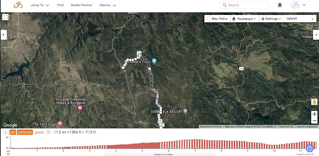
1. Bear Spring (USFS 681/284.2L/284.2A)
USFS 681/284.2L/284.2A along Bear Spring Creek to Alkali Spring.

USFS 681 starts from U.S. Highway 16 looking to be a pretty well developed back road to connect with Custer Limestone Road (USFS Primary Road 284) in about 8 miles. However, USFS 681 turns onto USFS 284.2L, which deteriorates as it enters Hell Canyon to follow Bear Spring Creek, where the walls close in. If that is flooded, I head back to Bear Spring and take a different Low Standard Road (USFS 284.2B/284.2C) that traverses the adjacent hillside to the East to connect with Custer Limestone Road.

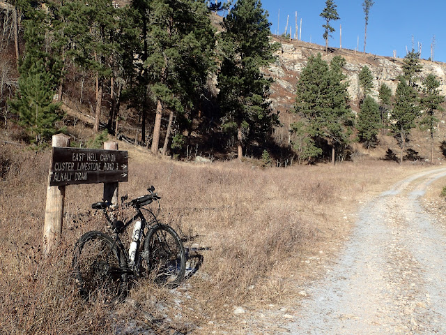
A rare sign along a Low Standard road in the Black Hills.


2. Booms Canyon (USFS 682/335.1D/335)
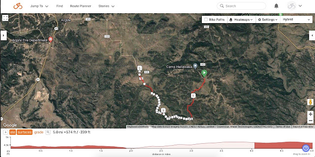
USFS 682/335.1D/335 to disperse camp near Booms Canyon.

Whether coming off of Wildcat Canyon (USFS Secondary Road 682) or Argyle Road (USFS Primary Road 333), this little 5 mile loop is a nice break on rough two track into an island of National Forest surrounded by private land. The initial rocky descent climbs back up to a ridge with 360 degree views and some cover for dispersed camping. This little chunk of isolated Black Hills National Forest solved a camping problem for me when scouting the route for Day 4 of the 2021 Black Hills Bounty. 

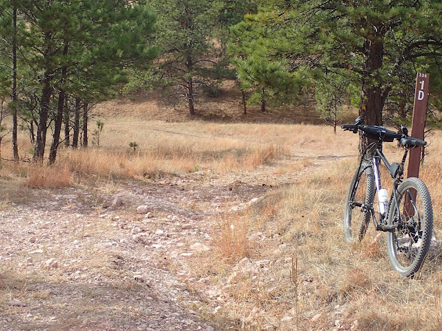
USFS 335.1D enroute to Booms Canyon.


3. Burnt Fork (USFS 389/389.1F/389.1D/530.1A/530)
USFS 389/389.1F/389.1A/530.1A/530 on classic Black Hills Low Standard Roads.

Starting from Deerfield Lake Road and the Mickelson Trail, Burnt Fork Road (USFS Secondary Road 389) rolls past small ranches to the restored Gold Mountain Mine, which is well worth the short hike. Shortly thereafter, USFS 389.1F climbs along Friday Gulch to eventually drop down USFS 530.1A to Slate Creek. These are classic Low Standard roads in the Black Hills:  a constantly changing mix of surfaces and pitches, up and down, through dense pine forests with occasional big views, a creek prancing down a craggy valley, and even an active logging area. After almost 12 miles, it pops out at the Mickelson Trailhead and on Mystic Road near the Redfern Trailhead.

USFS 530.1A dropping toward Slate Creek.


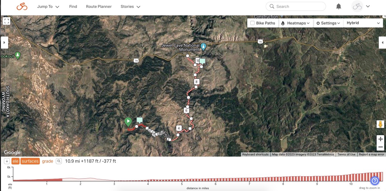
4. McKenna Springs to Jewell Cave (USFS 270.1A/270.1Z/unnumbered/277)
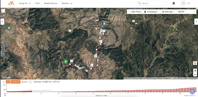
USFS 270.1A/270.1Z to unnumbered/abandoned road to USFS 277.

I discovered this little gem while scouting for a connector between Schenk Canyon and Hell Canyon for Day 4 of the 2022 Black Hills Bounty bikepacking ride. See Connecting. This 11 mile connector starts from Mann Road (USFS Secondary Road 270), turns onto USFS 270.1A as a mellow double track, turns more rough onto USFS 270.1Z, dissipates into nothing but tall grass for a hundred yards or so, and re-appears as a rocky, unnumbered, abandoned road that does not appear on a USFS map. Drop down that rocky pitch to McKenna Spring for fresh water, dispersed camping, and a short two track to USFS 277, which winds north to U.S. Highway 16 near Jewell Cave National Monument. 

This may well be my all time favorite Low Standard road find.

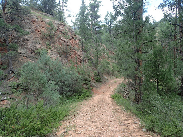
Unnamed and unnumbered abandoned road not on a USFS map.
McKenna Spring lies at the bottom of this hill in about a mile.


5. Bear Mountain (Unnumbered/unnamed to USFS 285.1A)
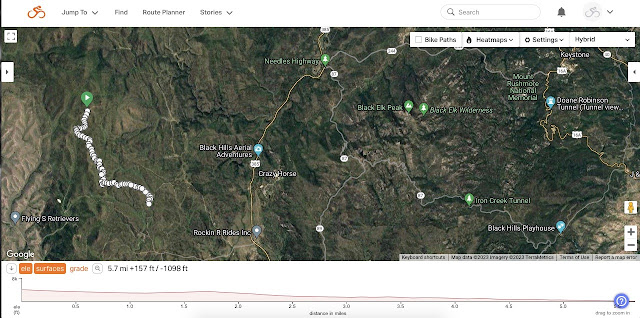
Unnamed/unnumbered road to USFS 285.1A to Saginaw Road.

Just west of the Bear Mountain Lookout Tower lies a nice clearing to disperse camp with an unnamed, unnumbered two track leading south. For about 3 miles, that gentle two track winds through aspen trees, hinting of hills to come. Then it rounds a corner to reveal a fleeting view of Crazy Horse Memorial before dropping onto USFS 285.1A for another 3 quick miles to Saginaw Road (USFS Primary Road 285). I discovered this route after finding that the Forest Service had barricaded with barbed wire my planned rough road descent off Bear Mountain. It all worked out, as I scouted around to find this great little, unnamed, unnumbered road.

Streaming off Bear Mountain on an unnamed,
unnumbered two track that leads to USFS 285.1A.

So many other Low Standard roads could have made this list, such as Galena north on USFS 567.1C/567.1/172.1; Hawkright Canyon on USFS 275; Pilger Mountain on USFS 319; Idol Gulch to Pole Cabin Gulch to Cement Ridge on USFS 803.1/802.1/1603; Richardson Cut-Off on USFS 276; Rifle Pit Canyon on USFS 806.1; Rhoads Spring on USFS 189; and Gillette Canyon on unnamed USFS 383. As a practical matter, there is a lifetime of Low Standard roads in the Black Hills to explore.

Going forward, maybe I should write an annual post identifying five favorite Low Standard roads that I discovered that year. I know I won't run out of material.

Sunday, March 5, 2023

Five Favorite Black Hills "Gravel" Roads

The Black Hills of South Dakota offer untold miles of back roads of all kinds. Up, down, and winding all around the Hills, these roads often were built to access logging or mining areas, cattle ranches, or the occasional small town. Practically limitless possibilities await the adventurous cyclist.

In the midst of such abundance, some stretches of certain roads stand out. I'll limit this post to Primary and Secondary roads, on which most experienced cyclists could comfortably ride on "gravel" bikes with tires of 40 mm, or so. So, here are five of my favorite "gravel" roads in the Black Hills.

NOTE: These are stretches of roads, not routes. If you find one of these roads on a route, you're off to a good start. The 2017 Rochford Black route featured in last week's post has two! Maybe that's why it's a favorite route from the Black Hills Gravel Series. See Taste of Black Hills Gravel.

1. Antelope Ridge Road (USFS 283)
Mud Spring Road (282) to Antelope Ridge Road (283).

From U.S. Highway 16 just west of Jewel Cave National Monument, Mud Spring Road (USFS 282) climbs along Hell Canyon for a few miles and then intersects with Antelope Ridge Road (USFS 283). Both eventually T-bone with Custer Limestone Road (USFS 284) and both are great fun. However, the views from Antelope Ridge Road are as big and wide as the Great American West, stretching well into Wyoming. Go West, young cyclist!

Antelope Ridge looking North and West into Wyoming.

2. Black Fox Camp Road (USFS 233)
Black Fox Camp Road (USFS 233).

Black Fox Camp Road is a long time favorite that I have featured in many posts. Indeed, in 2014, I plugged it into my first draft of the original Black Hills BackBone route and there it remains. Many other routes take it, including my new BackBone Grande bikepacking route. Only because this list is alphabetical is it second here.

West of Rochford off South Rapid Creek Road (USFS 231), this packed dirt road gently climbs along a meandering stream patrolled by busy beavers working dense stands of willow. As the valley narrows, pine trees give way to towering cliffs. It all ends too soon, but a bonus sits a few miles ahead by taking USFS 189 up to Flag Mountain Lookout. For me, this is five of the best miles anywhere.

Black Fox Camp Road. Simply the best.

3. Castle Peak Road (USFS 181)
Castle Peak Road (USFS 181).

Another lightly developed and barely maintained road, Castle Peak Road (USFS 181) winds along a creek to popular USFS Castle Peak Campground. This dirt road is often pot-holed and rutted, with some standing water, but is great fun on a gravel bike. From Mystic Road, it climbs steadily, but not steeply, at least not until the final two miles.

Creek to the left. Cliffs to the right. Here I am, stuck in the middle with trees.

4. Red Canyon Road (Fall River County 15)
Red Canyon Road (FRD 15).

A few miles north of Edgemont, Red Canyon Road (FRD 15) veers off U.S. Highway 16 for a relaxing climb through a hardscrabble canyon past a smattering of small ranches. Numerous flash flood drainages cross over the county road as it works up the canyon. Keep an eye on the canyon walls, however, for a variety of eroded formations and crevices. It's a visual feast unlike anything else in the Black Hills.

Fast county gravel crosses several flash flood washes en route to Red Canyon.

5. Red Valley Road/Highland Ridge Road (NPS 5)
Red Valley Road/Highland Ridge Road (NPS 5).

From graveled 7-11 Road west of Buffalo Gap, Red Valley Road rolls north past a couple of ranches into Wind Cave National Park. Then Highland Ridge Road (NPS 5) steadily climbs from the prairie into the forested Black Hills. The money view is from atop the ridge looking back toward Buffalo Gap.

I ride this road several times every year as an out and back from Buffalo Gap to the Centennial Trail intersection. This is a great winter ride, as it's generally uphill into the prevailing wind on the 15 miles out and then a joyous cruise home. Every time I see buffalo. Every single time. Be prepared.

Looking southeast toward Buffalo Gap on NPS 5.

I could easily expand this list by another five, ten, or more favorite Primary and Secondary roads in the Black Hills. For example, Glen Erin Road (USFS 337) with a spur up Cicero Peak southeast of Custer,  Lame Johnny Road in Custer State Park, Battle Axe Road (USFS 386) west of Hill City, Williams Draw Road (USFS 691) south of Deerfield Lake, and Warren Peak Road (USFS 838) north of Sundance. 

So much to ride and discover. But if you're just starting out, you may as well start with the best. 

Public Service Announcement.