The Cloud Peak 500 is a 500 mile remote road loop in and around the Big Horn Mountains of Wyoming. This post is part of a series that describes some of each day's logistics involved when we rode the route on bicycles loaded for a 7-8 day self-supportedtour in early August 2020. It also includes a screen shot and link to a digital map on ridewithgps.com, which I created after the trip to show our ride for each separate day. Finally, it adds a photo gallery. This post covers Miles 52-104 of the route, which was our Day 2. Go to Miles 0-52 for Logistics for Miles 0-52 (Day 1).
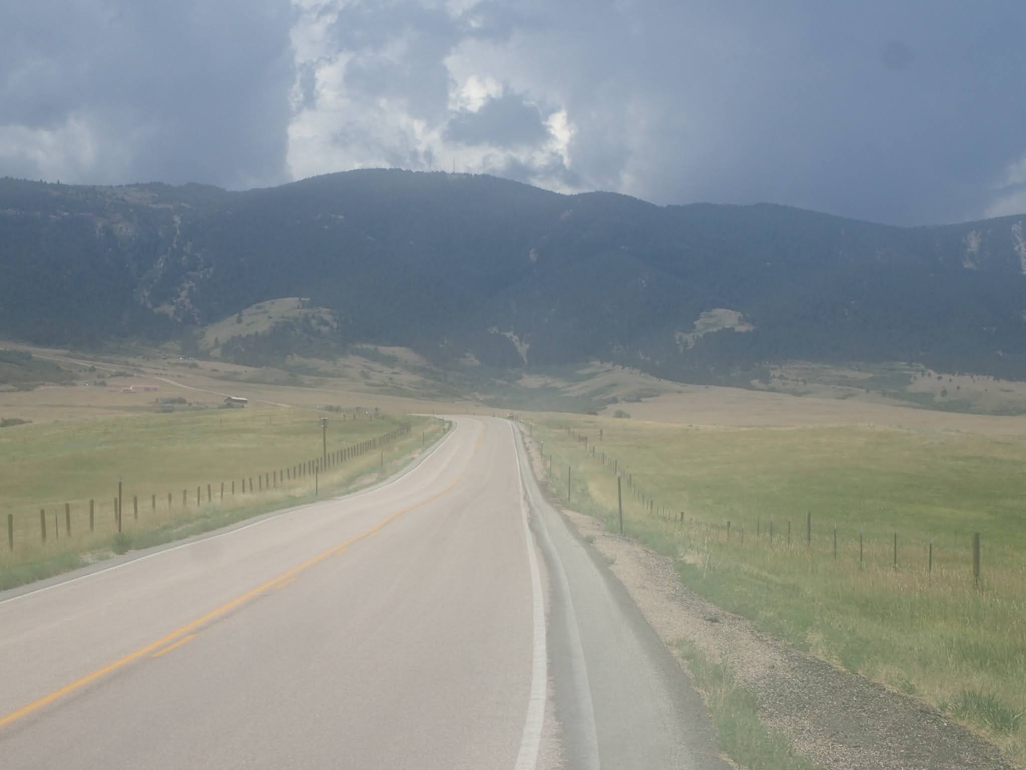
We start Day 2 from USFS Ranger Creek Campground at Mile 52 at an elevation of about 7,700 feet. The route continues climbing Red Grade Road (26) about 11 miles to over 9,300 feet at Mile 63. Relative to the climb from Big Horn, the gradient is significantly less and the road surface is consistently good. The route winds through forested hills with occasional views of big peaks. It then drops about 1,000 feet over the next 10 miles to about 8,300 feet at Mile 73, all on good gravel. If you need water or an outhouse, stop at USFS Dead Swede Campground at about Mile 72. There's a small incline before dropping quickly on good gravel and then generally downhill pavement on U.S. Highway 14 to Burgess Junction at about Mile 82. This is a very nice 30 mile stretch of remote mountain roads.
From Burgess Junction at Mile 82, look to the west to see Bear Lodge Resort. This is the last commercial establishment until the town of Shell at about Mile 139. We stopped for water and a long lunch break of burgers, fries and Cokes. Good, solid short order food. Paul also recharged batteries and electrical devices.
Back on the bike, the route turns north for about 5 miles of rolling gravel through treeless hills and then climbs steadily for the about 6 miles to gain another 1,200 feet. The gravel is good, but the climb is relentless and exposed to the elements, with exceptionally long sight lines and views. A short descent leads to a steeper 2 mile climb to Kane Cow Camp at about Mile 96 and the afternoon's high elevation of about 9,100 feet. No cowboys were at the camp when we were there on Thursday, August 6, 2020, but it was set up for a large operation that appeared to be happening soon.
The following 6 miles or so primarily descend on good gravel through trees. Both the descent and the trees are a pleasant change. The route then climbs gradually along a valley, with many places to disperse camp in and out of trees. We camped at a great spot at about Mile 104.
Overall, the route from Ranger Creek Campground to our dispersed camp is about 52 miles and 5,000 feet of elevation gain. For the Cloud Peak 500 route so far, that's about 104 miles/11,800 feet of elevation gain total.
It's a hard life to live, but it gives back what you give And I'm not missing a thing, watching the full moon crossing the range Riding the storm out. Riding the storm out. Riding the storm out. Riding the storm out. Riding The Storm Out, Gary Richrath, REO Speedwagon (1973).
Dawn breaks early, after yesterday's meltdown. Our Cloud Peak 500 trip hangs in a precarious balance. My morning Bible study is brief and simple, leaving me with a singular thought. Trust.
I quietly pack, eat a hot breakfast and ease out of Ranger Creek Campground as the sky ambles toward blue. Today I carry no expectations. I'll pedal into whatever the day brings. Trust.
The first 11 miles climb about 1,600 feet to an elevation of about 9,300 feet. Then the route rolls generally downhill, with a few bumps, to Burgess Junction at about 8,100 feet at Mile 82. There we plan to stop at the Bear Lodge Resort to eat lunch, top off water, and re-charge batteries. We also will decide whether to continue this trip or not. Trust.
Red Grade is a hard road to ride, but it gives back what you give.
But today is not a day for numbers. Today is a day to just ride. A day to find a sustainable rhythm and a positive mindset. To enjoy the day, whatever it brings. Whether the end of the trip, a fresh start, or something entirely different.
Right away, I feel good. Solid. Smooth. Comfortable. Familiar. I'm turning pedals at a steady cadence on a cool morning ride in the mountains. I feel at home. This is good. This is very good.
The initial 11 mile climb winds up forested mountains, with occasional glimpses of snowy peaks above. It's a civilized start today, thanks to the reasonable grade, solid road surface and moderate temperatures. The miles pass calmly, almost meditatively. Before long, we pull into the USFS Dead Swede Campground for a congratulatory break. The big climb up Red Grade Road is essentially over.
Early on Day 2, I'm riding the storm out on Red Grade Road. (photo by Paul Brasby)
What a wonderful morning. We cruise mostly downhill to U.S. Highway 14 and then a few paved miles to Burgess Junction at Mile 82. Well before noon, we've covered about 30 miles and gained about 2,500 feet of elevation. More importantly, I feel great. With a short break to re-fuel, I'm ready to roll.
So, just like that, the anticipated big decision at the Bear Lodge Resort turns into a non-event. No turning off this trip. I'm back.
We order burgers, fries and bottomless Cokes. Paul adds a salad and some snacks for the road, while charging his batteries. Conventional tourists stop by to chat, ask questions and share their cycling stories. It's a relaxing, replenishing, re-affirming break.
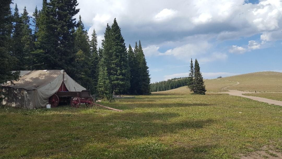
Paul Brasby and Craig Groseth celebrating at USFS Dead Swede Campground, Mile 72.
Leaving the comforting confines of Bear Lodge Resort, we turn north on USFS 15 to climb into the largely tree-less expanse of Bull Park up to the high altitude Kane Cow Camp. By now, the sun burns brightly, but not unreasonably hot at our 8,000+ foot altitude. Yee-Haw! We're about to enter the high country of the Northern Big Horns.
We roll comfortably for several miles and then climb steadily for another 6 miles on solid gravel roads with moderate gradients. This stretch requires some work, but rewards with ever-expanding views, above and below. Other than a couple of cowboys in pickups, we ride alone.
Climbing toward Kane Cow Camp at an elevation of about 9,100 feet.
A couple of steep switch backs and a long, sweeping pitch bring us up to Kane Cow Camp, the top of this climb at about Mile 96 and 9,100 feet elevation. We have ridden past other spots identified as "cow camps" along the route, but they have been devoid of people and equipment. Here, Kane Cow Camp looks to be completely set up for a large round up soon, although we don't see anyone there.
We drop down Dayton Gulch a bit as it winds toward the Little BigHorn River. The gravel road remains relatively firm and fast, rolling between 8,500 feet and 9,000, in and out of the forested mountains. Then, an unexpected, almost 4 mile descent elicits random hoops and hollers as we coast those loaded bikes up to warp speed. Sweetness! Rock & Roll is here to stay!
After that boost to morale and average speed, we climb gradually along the Little BigHorn River, as the afternoon wanes. Not far ahead, the route crosses U.S. Highway 14A and turns decidedly up and above tree line. We look for a nice spot to disperse camp among the trees.
Riding into the Clouds and toward the Peaks on Day 2. At this point, we're not ready to camp anyhow.
We spot a picturesque meadow at the edge of the forest with a stream and mountain top view to the east. Perfect spot. Perfect time to stop for the day. Perfect place to start tomorrow's ride.
After pitching our tents, we process the day over a hot meal. In total, we rode 52 miles and gained over 5,000 feet of elevation. So, for Paul, that makes 104 miles and 11,800 feet of elevation gain for the first 2 days. I'm at 93 miles and 9,200 feet of elevation gain, due to my truncated Day 1.
As the day unfolded, we certainly could have ridden more miles, but this day was not about numbers. We rode steadily all morning, ate a solid meal at a long lunch break, and continued to ride steadily into late afternoon. Throughout the day, we successfully managed hydration, nutrition, heat, effort, and, most importantly, mindset. We started and ended during day light at reasonable hours. We even found a great camp site in time to enjoy a quiet evening watching the surrounding mountains turn colors as the sun set.
Sunset reflected on a mountain top from our dispersed campsite.
This day is awesome. This day is why we ride. And why we continue to ride after a day like yesterday.
Our Cloud Peak 500 trip continues, as we ride yesterday's storm out.
I begin the day focused on trust. I finish with gratitude.
The Cloud Peak 500 is a 500 mile remote road loop in and around the Big Horn Mountains of Wyoming. This post is part of a series that describes some of each day's logistics involved when we rode the route on bicycles loaded for a 7-8 day self-supportedtour in early August 2020. It also includes a screen shot and link to a digital map on ridewithgps.com, which I created after the trip to show our ride for each separate day. Finally, it adds a photo gallery. This post covers Miles 0-52 of the route, which was our Day 1.
The Cloud Peak 500 starts and ends in downtown Sheridan, Wyoming, which offers many motels and restaurants. In fact, Paul stayed across the street from the start/finish at the America's Best Value Inn. He also obtained permission from the motel manager to leave his truck there for the next 7-8 days during our trip. I stayed a few miles to the south in a Day's Inn. Both worked. The night before the start, we met for dinner at Ole's Pizza & Spaghetti House, which sounded fun but received ho-hum reviews from my wife and daughter. I thought the burgers and fries were good.
Onto the route, the Cloud Peak 500 starts in downtown Sheridan on East 5th Street in front of the Health Nut & Wellness Center and simply heads west out of town on 5th Street. Do not underestimate or overlook the 34 miles to the town of Big Horn, which took us about 5 hours to ride. Right from the start, the route goes uphill. Soldier Creek Road (74) turns to good gravel, but is uphill for much of the 15 miles to Beckton Road (89). South on Beckton Road (89) rolls more often, up and down, but occasionally the grades are steeper and the road surface softer. Then Big Horn Road (99) has pitches even steeper and softer, although they are not long. The generally downhill final 4 miles into Big Horn are a pleasant break. There is no shade or wind break on any of it. There are no services of any kind, either. By mid-morning, it was plenty hot.
In Big Horn, we found two commercial establishments on the route, both of which were closed until 4:00 pm. That wasn't much help at noon. One, a restaurant sporting a misleading "Big Horn Mercantile Co." sign, was receiving a delivery and the cheerful delivery person managed to convince a reluctant employee to allow us to refill our water bottles from a bathroom. Then, as we were leaving, I heard the restaurant manager say, "Lock the door, so no one else tries to come in." So, I would not depend on water from those two businesses in Big Horn. In contrast, throughout the entire remainder of our week long trip, all the other locals we encountered were fantastically friendly and helpful. I would not hesitate to ask for water from anyone passing by in any kind of vehicle. I also would not hesitate to knock on a door to ask for water.
Turning south and then west out of Big Horn, the route passes some houses while climbing steadily on pavement and then gravel. The good surface, and the steady, significant climb, continue until about the first big switchback. Then the road points decidedly upward and the road surface gets softer. The next 5 miles or so throw some of the steepest pitches of the entire 500 mile route, including one that reportedly is 19 percent. The road also enters Big Horn National Forest, where it is less developed and less maintained. After that stretch, the road still climbs, but at a lesser gradient and with a few short breaks. Finally, near the end of the day, trees appear for the first time other than around Big Horn.
From Big Horn, the route climbs about 4,300 feet in 18 miles to USFS Ranger Creek Campground, again with no commercial establishments of any kind en route. Once there, Ranger Creek Campground has drinking water, an outhouse and camp sites with picnic tables and fire grills. We camped there at the end of our Day 1.
By the way, some maps show a "Big Goose Campground" at this place. On site, the USFS campground is signed as "Ranger Creek Campground," while an adjacent building site is signed as USFS "Big Goose Ranger Station." To add to the confusion, the USFS map for Big Horn National Forest shows 2 different campgrounds identified as "Ranger Creek Campground." The other one is located about 15 miles due west near the Adelaide Trailhead leading into the Cloud Peak Wilderness Area.
Overall, the route from Sheridan to Ranger Creek Campground is about 52 miles and 6,800 feet of elevation gain. For the Cloud Peak 500 so far, that's about 52 miles/6,800 feet of elevation gain total.