Search This Blog

Sunday, July 30, 2023

BackBone Grande (Days 5 & 6) - Low Standard and Lower

Good Forest Service gravel roads permeate the Black Hills. A typical passenger car can handle the Primary roads and many good Secondary Roads. A bit more vehicle clearance and driver judgment opens up most of the remaining Secondary Roads, absent weather issues. All these roads are well mapped and are great fun for a day ride on a gravel bike. See, The Good, The Bad & The Ugly

The Black Hills also feature a practically unlimited assortment of Low Standard Roads, numbered motorized use trails, unnumbered often abandoned two-track, unnamed trails, and other backcountry pathways. The design, construction, and maintenance of these "roads" are all over the map. There's no way to know what's really there without getting out there.

The BackBone Grande seeks out those little known and less traveled roads to create a unique experience for bikepackers, while still following some Primary and Secondary Roads for re-supply and to access landmarks such as Wind Cave National Park, Custer State Park, Crazy Horse Memorial, Mt. Rushmore, Mickelson Trail, Spearfish Canyon, and Roughlock Falls. Perhaps nothing shows this better than the journey between the village of Rochford and the college/mountain bike town of Spearfish. 

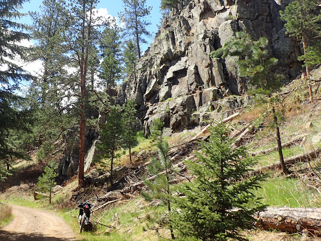
Abandoned Old Baldy Road swings through a lost canyon.
(image by Paul Brasby)

We start our Day 5 of the BackBone Grande from a campsite near Rochford, where mornings always seem cold. A gentle 8 mile climb up bucolic South Rapid Creek Road (USFS Primary 231) leads to picturesque USFS Black Fox Campground, a popular site for a variety of outdoor enthusiasts. Then we roll up Black Fox Camp Road (USFS Secondary 233), another all-time favorite of mine. See, Five Favorite Black Hills Gravel Roads. With cool temperatures, no wind and clear skies, we smooth roll these early morning miles and soak in the quiet Black Hills vibe.

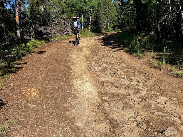
After that nice warmup, we eagerly turn onto Low Standard Road 189 to start in earnest our venture onto less developed roads. Road 189 starts little different from Black Fox Camp Road, but earns its lower designation as it climbs. Yearning for more, we continue onto Low Standard Road 631.2 for about 4 miles of even more ruts and rocks, with more up than down. It's all rideable, but can be messy. We skirt some mud and water filled pot holes, although nothing like the quagmire when I rode it a few weeks ago.

South Rapid Creek Road (USFS Primary 231) out of Rochford.
(image by Paul Brasby)

Spinning up skinny Black Fox Camp Road (USFS Secondary Road 233).

Road 631.2 abruptly ends at South Rapid Creek Road (USFS Primary Road 231). So, we turn onto that good gravel road for a couple of fast miles to connect with Long Draw Road (USFS Secondary Road 209). Rolling for about 8 miles over a series of long downs and a few ups, we regain a little rhythm here on the solid surface and moderate grades.

Then we ride onto Hanna Road (USFS Primary Road 196) to very nice USFS Hanna Campground, which sure looks to be a promising destination for a touring cyclist. We stop to check out the walk-in tent area, water, toilets, and picnic tables along rushing Spearfish Creek. It looks great, but we're not nearly ready to stop for the day.

From the campground, Hanna Road drops a couple of more miles to Cheyenne Crossing for food, re-supply, and cabins, if desired. As some clouds gather, we take a late lunch break at the busy cafe.

Paul about to grunt up a pitch on USFS Low Standard Road 631.2.

More Low Standard Road goodness on 631.2.

From Cheyenne Crossing, the BackBone Grande drops down paved U.S. Highway 14A, aka Spearfish Canyon Scenic Byway, renown for the striking canyon walls towering over raging Spearfish Creek. Although the road is paved without much shoulder, we comfortably drop down the 5 quick miles to Savoy, another town abandoned but for a cafe and a resort. Traffic picks up here, so stay alert.

At Savoy, we turn onto Roughlock Falls Road (USFS Secondary 222) to start climbing again. But it's only a couple of gentle miles to Roughlock Falls and this canyon is stunning, as well. Roughlock Falls is a very popular destination for tourists and locals, with trails, boardwalks, interpretive signs, picnic tables, bathrooms, and ample parking space. We stop, too.

Up the canyon a few more miles lies USFS Rod & Gun Campground and, a couple of miles further, USFS Timon Campground. Although both were full, the friendly campground host allows us to carve out some unused space at Timon to pitch our tents. We decide to stay there despite our relatively short day and the abundance of disperse camping opportunities ahead. After all, we're touring the BackBone Grande, essentially as a final recon ride. We have maps to study, pictures to take, things to consider. No rush.

Coasting down Spearfish Canyon Scenic Byway (U.S. Highway 14A).
(image by Paul Brasby)

Bright sun battles dark clouds on Roughlock Falls Road (USFS Secondary Road 222).
(image by Paul Brasby)

Day 6 breaks open bright and early, with hardly a cloud in sight. We gratefully stow our rain jackets and spin up the remaining few miles on Roughlock Falls Road. The gradient minds its manners, the notoriously rough surface doesn't materialize, and the canyon walls continue to reveal their splendor. What a way to start the day.

Spinning up Tinton Road (USFS Primary Road 134) for about half a mile, we eagerly turn onto School House Gulch Road (USFS Secondary 222). This solid gravel road circles west, turns north through a large area of private land surrounding the ghost town of Tinton, and then runs east back to Tinton Road. However, we don't take that entire loop.

Roughlock Falls Road (USFS Secondary 222).
(image by Paul Brasby)

After just a couple of miles on School House Gulch Road, we reach a barely marked right hand turn onto Pettigrew Gulch Road, an unnumbered public road. Over the next mile or so, it passes a few homes and, just before it ends at a private residence, the route turns 90 degrees left (west) to drop to a gate. Through that gate awaits 2 miles of discovery deep in Black Hills National Forest.

This abandoned two-track, sometimes single track, and occasionally hard-to-follow track is closed to motorized vehicles and appears to be an old road that eventually simply turns into Old Baldy Road (USFS Low Standard Road 633.1). Here, however, it's a rolling, overgrown path through meadows and trees, with creek and gate crossings to negotiate. The surprising bonus is a small, but striking canyon with sheer rock walls looming over a rushing creek. Truly a hidden gem.

Abandoned road eventually turns into Old Baldy Road (USFS Low Standard 633.1)
(image by Paul Brasby)

I'm not lost, but I'm not sure about that guy behind me.
(image by Paul Brasby)

An old wooden bridge complements the barely recognizable trail.
(image by Paul Brasby)

The old road bed is visible as Paul enters a small canyon.

After just a couple of miles, that short, sweet abandoned "road" turns into Old Baldy Road for a bumpy ride that ends at School House Gulch Road, several miles to the north from where we left it. We do little but cross that Secondary Road and hop right back on another unnumbered, abandoned two-track. This one starts by quietly following Beaver Creek along a grass covered hillside.

These little two-tracks are great fun and the miles pass far too quickly, even when moving slowly along the rough, untended surface. We ride out of trees and into meadows, and vice versa, relishing the tranquility. After just a mile or so, however, the two-track announces the end of this polite, mellow jaunt by swerving 90 degrees to plow straight up the hillside to a ridge line. That's a bit of a jolt, but we grind up that mile long pitch and celebrate in some shade at the top.

Unnamed, unnumbered two-track following Beaver Creek.
(image by Paul Brasby)

Climbing out of the Beaver Creek valley.
(image by Paul Brasby)

Paul leaves Beaver Creek behind to seek the next ridge line.

We land on unnamed USFS Low Standard Road 130, a curiously well built and maintained Low Standard Road that follows a ridge line for several miles and then simply dead-ends. A number of less developed roads and tracks spin off Road 130, so perhaps it was built long ago for some logging activity. In any event, we enjoy a mostly downhill 4 mile spin on this solid road that rides much more like a Secondary Road. With all the aspen trees, this stretch is sure to be pure gold in the fall.

Of course, when we leave Road 130, it's onto a yet another unnamed, unnumbered two-track. This is a bit more rocky and rutted, but again it's mostly downhill to Higgins Gulch Road (USFS Secondary Road 214).

Rolling through aspen groves down a ridge line on USFS Low Standard Road 130.
(image by Paul Brasby)

Dropping down a final two-track to Higgins Gulch Road.
(image by Paul Brasby)

Miles flow smoothly and quickly down Higgins Gulch Road. Far too soon, we bottom out on the west side of Spearfish. We ride by two bike shops, breweries, restaurants, fast food places, C-stores, grocery stores, and more. After a re-supply and lunch stop, we even ride right through downtown, past Spearfish City Park, and right into the Spearfish City Campground.

It's yet another short day when we decide to stay in the very nice city campground. We pitch our tents right next to Spearfish Creek and actually order pizza that is delivered to the campground. How's that for living large in the big city?

The Black Hills now are behind us, along with all those amazing Low Standard and lower roads. Tomorrow we launch into the Northern Prairie for the final 150 miles or so to the North Dakota border. Maybe we'll find more friends in low places.


Sunday, July 23, 2023

BackBone Grande (Days 3 & 4) - Rain

Bikepacking back country roads for days or weeks at time certainly includes dealing with rain. Sometimes, you ride it out. Sometimes, you wait it out. Sometimes, you may even have a choice.

In any event, rain leaves its mark on remote gravel and dirt roads. And on your experience.

Starting with Day 3, we encounter rain and its aftermath every day of our June ride of the BackBone Grande. On both Days 3 and 4, we handle some major thunderstorms by sitting out 3 hours during the worst of it and riding through the rest. So, the big storms never really drench us or our gear. The roads, however, are not so well protected.

Maneuvering up Castle Peak Road through the mud and standing water common there.
(image by Paul Brasby)

Day 3 opens with bright sun and fluffy clouds. The forecast is more ominous, however, with a major thunderstorm slated to arrive before noon and others to follow, probably well into the upcoming week. 

From French Creek Horse Camp, we sit about 14 miles of gravel, single track, two-track, and bike path away from Custer. We aim for Baker's Bakery for a late breakfast, hopefully before the big rain.

We climb out of the French Creek valley on good gravel to paved highway 87 and roll past the well stocked Blue Bell C-store, cafe, and cabins. Crossing a wooden pedestrian bridge to a picnic area, we turn onto a nifty unmarked, unnamed single track that follows French Creek for about a mile to connect with Hazelrodt Picnic Area and then Hazelrodt Cutoff Road (USFS 341). That single track is overgrown from little use, but navigation is easy-peasy after enduring Buffalo Gap National Grasslands.

Unmarked, unnamed single track following French Creek.
(image by Paul Brasby)

One final obstacle at the end of the single track.

As a USFS Primary Road, Hazelrodt Cutoff Road handles water well and gently flows through a quiet valley, dotted with homes and even new construction. Just as body and bike grow accustomed to a relatively smooth rhythm, we abruptly turn onto USFS Low Standard Road 341.1 for a muddy, pot-holed, rocky little climb to a ridge line. The visual payoff is an early morning view of the Cathedral Spires, but also of storm clouds gathering to the west.

We bounce down the north side of the ridge to a paved bike path dropping us off on the east side of Custer, just as the first real rain drops fall. Before entering downtown Custer, the route turns north on the Mickelson Trail. Not now. We skedaddle into town. The thunderstorm is here.

Starting the short climb up USFS 341.1.
(image by Paul Brasby)

If not mud or standing water, count on rocks on USFS 341.1.

Custer is a small tourist town offering a variety of lodging, re-supply, and food options, including favorites Baker's Bakery, Black Hills Burger & Bun, Skogen Kitchen, Purple Pie Place, and Horatio's Homemade Ice Cream. The South Dakota Outdoors Store even carries a good selection of camping and some bicycling supplies. Good stop.

We arrive at Baker's Bakery just as the heavens open and, perhaps more importantly, just in time to order from their breakfast menu. So, we stay warm and dry inside while inhaling a fabulous omelette and multiple cups of hot coffee. Meanwhile, rain keeps pouring out of those dark clouds, although the forecast looks promising shortly. So, we stay a bit to wait it out. More hot coffee, some mouth watering pastries, and three hours later, we finally pack up.

After the deluge, we roll out of Custer on the Mickelson Trail.
(image by Paul Brasby)

That first thunderstorm moves on, leaving the earth soaked. We roll out of Custer on the Mickelson Trail, which fortunately handles water well. For five scenic miles, we slowly climb a valley overlooked by ancient granite formations that hint of their massive size in ages past. We top a ridge for a view of Crazy Horse Memorial and re-join Forest Service gravel and dirt roads to ride directly into the heart of the Hills.

At Reno Gulch Road (USFS Secondary Road 303), the road narrows and roughens. Granite outcroppings jut upwards, opening crevices for marmots and other critters to dwell. USFS Low Standard Roads scatter in all directions, inviting exploration. I love scouting roads around here, but not today. Today we're riding the BackBone Grande.

With the three hour layover in Custer and with the next thunderstorm advancing with bad intent, we intently climb up to Coad Hill for a big view of Harney Peak and scream down the east side toward Hill City. More rain starts to fall and much more is coming real soon, so we call it a short day and secure a motel room in Hill City. That turns out to be a very good call.

Watchfully passing "Marmot Motel" on Reno Gulch Road.
(image by Paul Brasby)

The forecast promises more thunderstorms throughout the night and into the morning. We decide to do laundry, sleep in, enjoy the motel breakfast, and wait it out. Sure enough, it rains heavily into the night, early morning, and well after. When it finally lets up a bit at about 11:00, we take off. We avoid the worst of it for the second straight day and the forecast now looks better. We hope so, as there will be no opportunity for a cozy shelter like this tonight.

Finally pedaling on Day 4, we cruise on the Mickelson Trail through a little aspen alley to connect with Burnt Fork Road (USFS Secondary Road 389) that leads to Gold Mountain Mine. This historic mine closed long ago, but its surface buildings are structurally restored, some original heavy equipment remains, and interpretive signs help tell its stories. This stop is well worth the short pitch from the road.

Little aspen alley on the Mickelson Trail north of Hill City.
(image by Paul Brasby)

Up that short pitch ahead awaits Gold Mountain Mine.
I took this image a few years ago, on a day with much more sun than our Day 4.

Very shortly after Gold Mountain Mine, Burnt Fork Road turns onto USFS Low Standard Road 389.1F and then 389.1D. Roughened and rutted from ATV traffic, these roads are now enhanced with deep mud and standing water. Wide tires help, but this is a pretty slow slog for several miles. Once again, however, the ridge line we seek eventually firms up the road surface and reveals distant views of the higher elevations to the south, including Harney Peak. 

The thunderstorms of the past two days appear to have moved on, but heavy clouds linger and unseasonably cool temperatures persist. We're never really cold or wet, but certainly not warm and fuzzy, either. Extra layers and jackets stay on all day.

USFS Low Standard Road 389.1F.
(image by Paul Brasby)

Climbing above the mud to ridge line views on USFS Low Standard Road 389.1D.
(image by Paul Brasby)

We hop onto USFS Low Standard Road 530.1A for a relatively dry, rollicking roller coaster ride down to Slate Creek Road (USFS Low Standard Road 530). It's way too easy to go way too fast here. Like any other kid, we do anyhow, sometimes.

Slate Creek Road meanders up another stunning aspen filled valley and then abruptly climbs back up to the Mickelson Trail. We effortlessly cruise down this short stretch, passing through two hard rock tunnels to land at the Mystic Trailhead. Shelters, bathrooms, and water offer a welcomed break.

Blasting through a Mickelson Trail tunnel is never advised.
We came up on two horseback riders making their way through.

Riding south on Mystic Road under the Mickelson Trail bridge we just rode over.
(image by Paul Brasby)

Before long, and before more rain strikes, we roll up Mystic Road to start climbing Castle Peak Road (USFS Low Standard Road 181), one of my all-time favorite roads in the Black Hills. See, Five Favorite Black Hills Gravel Roads. Following closely along meandering Castle Creek, this narrow road hugs the mountainside and often sports large pot-holes filled with water. (See the first image of this post). Maneuver carefully, as the sharply curving road is also popular with the ATV crowd. 

USFS Castle Peak Campground awaits about 8 miles up the valley. Even with our late start, we're not ready to camp yet, so we slug up a suddenly steeper 2 miles to well-developed South Rochford Road. Then it's a fast descent on South Rochford Road to the village of Rochford. 

The day ends well when the grill is still open at the iconic Moonshine Gulch Saloon in Rochford. We feast on burgers and more, refill water bottles, and find a somewhat protected place to camp. So ends Day 4.

Over the last two days, we manage to sit out the worst of the rain and weather the rest. Thunderstorms may keep coming, but they don't dampen our ride of the BackBone Grande.

Riding up Castle Peak Road through off and on rain.
(image by Paul Brasby)

Castle Peak Road not surprisingly is popular with these beasts, too.
(image by Paul Brasby)


Sunday, July 16, 2023

BackBone Grande - Summer/Fall 2023 Detour

TEMPORARY ROAD CLOSURE AFFECTING THE BACKBONE GRANDE IN 2023.

The South Dakota Department of Transportation recently issued a press release announcing that the first 3 miles of South Rochford Road (C306) will be closed to traffic from July 5, 2023 until October 13, 2023 for a paving project. SD DOT Press Release on South Rochford Road Closure.

This affects the BackBone Grande in 2023 as the route follows those three miles. The bad news is that the road is closed until October 13, 2023 and that it will be paved when re-opened. The good news is that the road should be open all of 2024 and that the curvy downhill on primary gravel was often heavily washboarded anyhow.

The second phase of this project begins next spring and continues south from the end of the first phase. It should not affect the BackBone Grande route in 2024.

The map below shows the BackBone Grande route in red, with the affected portion in blue.

Shown in BLUE are the three miles of South Rochford Road that are temporarily closed.


Here are two simple detours for the BackBone Grande during this construction.

North Bound Riders

1. When reaching the Mystic Trailhead for the Mickelson Trail at about Mile 157, stay on the Mickelson for about more 8 miles to Rochford, where you will pick up the BackBone Grande route at about Mile 174. Proceed on the route toward Black Fox Campground. The biggest drawback to this detour is that you will miss all of Castle Peak Road (USFS Low Standard Road 181), one of my favorites.

2. Alternatively, when reaching the Mystic Trailhead at about Mile 157, continue on the route up Castle Peak Road to USFS Castle Peak Campground about Mile 167 and maybe over the narrow wooden bridge just beyond. Then ride back to the Mystic Trailhead and take the Mickelson Trail those 8 miles to Rochford to pick up the BackBone Grande route. That relatively short out-and-back is worth it for the road, scenery, and campground, especially if camping back there fits your timing.

South Bound Riders

1. When reaching Rochford, hop on the Mickelson Trail for 8 miles to the Mystic Trailhead, where you will pick up the BackBone Grande route heading south toward the tunnels.

2. Alternatively from Rochford, hop on the Mickelson Trail for 8 miles to the Mystic Trailhead, then take Mystic Road south to Castle Peak Road for a quick out-and-back and return to the Mystic Trailhead to pick up the BackBone Grande route. 

I know many folks dislike out-and-backs because it feels like riding the same thing twice. That's no longer my way of thinking, as I always find two very different experiences. 

Before you decide against riding the Castle Peak Road out-and-back, take a look at a few pictures.


Sunday, July 9, 2023

BackBone Grande (Day 2) - Trail #1

There are no easy days on the Great Divide Mountain Bike Route. Every day, bikepackers face all sorts of challenges, on all sorts of surfaces, in all sorts of weather. Many are unpredictable, but some are not. 

One well known and major challenge of riding the Great Divide is the occasional, off the charts, insanely difficult climb or descent. Lava Mountain, Fleecer Ridge, Union Pass, the watershed divide after Brush Mountain Lodge, Brazos Ridge, and Polvadera Mesa, for example. Part of the Great Divide experience is occasionally pushing your bike, and yourself. As hard as it is, it's always worth it. See, The Great Divide - The Toughest Climb.

Trail #1 in Custer State Park offers that experience on the BackBone Grande. That's why I put it in and that's why I'm leaving it in, even after "riding" it. If you seek a Great Divide type of experience, or you're preparing to ride the Great Divide, Trail #1 may be for you. Otherwise, bypass it. You've been warned.

Recovering from the first heft-a-bike pitch on Trail #1.
(image by Paul Brasby)

Day 2 of our ride of the BackBone Grande starts innocently enough as we roll out of Oelrichs on solid county gravel through the villages of Smithwick, Oral, and Buffalo Gap. In Smithwick, we chat with Sue, the local Postmaster who shares stories of local history while offering water, and Jerry, a retired Pennington County Correctional Officer who keeps an eye on things around town. 

On to Buffalo Gap, we stop for cold Cokes at the mind-boggling Buffalo Gap Trading Post. This place has so much stuff, and such a variety of stuff, inside and out, that it's hard to take in. Some of it may even be for sale. Elray, the proprietor, keeps adding to his establishment and to his assorted collections. American Pickers have nothing on him.

Steadily climbing through Wind Cave National Park toward Custer State Park.
(image by Paul Brasby)

The day warms up as we gently climb 7-11 Road, then turn toward Wind Cave National Park on NPS 5, a long time favorite gravel road of mine. See, Five Favorite Black Hills Gravel Roads. Prairie dogs scamper all over, occasionally even into holes they dig through the road itself. Buffalo, elk, deer, and pronghorn also roam these lands, so stay attentive.

Approaching Boland Ridge, we ride past a temporary tipi and tent encampment of the Ogallala Sioux tribe celebrating an annual ceremony. Then we quickly drop into Custer State Park onto the popular Wildlife Loop, where a smattering of tourists flock to feed the park's wild burros. A couple of short, paved miles later, we stop for shade and fresh water at the Wildlife Station Visitor Center. After gradually climbing much of the day, it's time to gather our forces for the climb ahead.

Relatively gentle climb up Lame Johnny Road in Custer State Park.
To bypass Trail #1, simply stay on this pleasant road to French Creek Horse Camp.
(image by Paul Brasby)

From the Visitor Center, the route steadily climbs almost 1,000 feet over the next 6 miles on the good gravel of Lame Johnny Road, Nature Trail Road, and Fisherman Flats Road. Climbing out of the prairie into the Black Hills, we enjoy occasional shade from the increasing number of trees along the way. After nearly 100 miles of riding through prairie, it feels that we're finally entering the Black Hills.

Twisting and turning, Fisherman Flats Road reaches up to the Hills as high as it can, before morphing into a rocky two-track that leads to a gate. From that trailhead, Trail #1 actually looks reasonable and rideable.

Fisherman Flats Road hints at what's ahead.
(image by Paul Brasby)

Trail #1 is an old two-track logging road long closed to vehicle traffic, but open for travel by foot, bicycle, and horse. The nearby, very nice French Creek Horse Camp provides a convenient base camp for horse back riders to readily access it and the state park actively promotes it to them. With heavy horse traffic to roughen up the ground and no vehicle traffic to pound it down, Trail #1 is not surprisingly very loose and very rough. An abundance of rocks and stupid steeps make much of it all but unrideable on a loaded bike.

From the gated trailhead, Trail #1 ambles for a half mile or so. Then, in the words of Goose from Top Gun, "We're going ballistic!" 

Early on Trail #1, I'm actually pedaling my bike.
(image by Paul Brasby)

A little bit later, I'm still pedaling. It doesn't last long.
(image by Paul Brasby)

This is hard. This is very hard. Steep, rocky, loose, rough. Now, I'm pushing the bike. When the sun pops through the clouds, it's hot with no chance of shade. I spot a saddle up an impossibly steep pitch and resolve to make it that far. After many stops to arrest my gasping, I reach that saddle and collapse. Watching Paul hoof up that pitch confirms its difficulty.

Perhaps the best way to tell the story of this pitch is by pictures.

The first heft-a-bike section. Not my first stop.
(image by Paul Brasby)

Almost to the first saddle.
(image by Paul Brasby)

Enough strength to lift one arm to encourage Paul.
(image by Paul Brasby)

You know it's steep, loose, rocky, and rough for Paul to be walking.

Stopped to recover, we marvel at the big views of the surrounding hills and the prairie far below. I question whether this is simply too much for the BackBone Grande. Paul encourages me to keep going.

Looking ahead, my elation of reaching that saddle vanishes at the sight of more steeps. We ride some, walk lots, and stop frequently. Trying to break this beast into smaller pieces, I resolve to count ten steps before stopping. Even when the gradient slackens a bit, the loose, rocky, rough trail takes enormous effort to climb, whether walking or pedaling.

It never gets easier. When we finally reach a short downhill, it's such a mess that we start by walking it. Further down is more rideable, but it's full on mountain bike territory on a loaded bike. Bring appropriate gear, ability, experience, and judgment to safely descend this stuff.

Working up another pitch that just doesn't look that steep. Let me know if you ride it.
(image by Paul Brasby)

Cresting another saddle on Trail #1 reveals big views all around.
Just a couple of hours ago, we were riding in that prairie far below.
(image by Paul Brasby)

We even walked some downhills.
(image by Paul Brasby)

Trail #1 winds about 3 miles from Fisherman Flats Road to connect with Lame Johnny Road. Whatever the elevation gain, we earn every foot. To cover those 3 miles, we work hard for about 2 hours. Yeah, it's at the end of a solid day mostly spent climbing with fully loaded bikes, but still. 2 hours to cover 3 miles! 

Know that a simple bypass of Trail #1 is to stay on Lame Johnny Road all the way into the French Creek Horse Camp. That's still a solid climb on a nice road with beautiful scenery. Nothing wrong with that, especially if you're not physically and mentally prepared for a Great Divide type of experience.

Paul joyfully rolls off Trail #1.

Late afternoon, we finally roll into French Creek Horse Camp. Even with the campground full of RV campers with their horses, the friendly camp host finds a nice, grassy spot next to the creek for us to pitch our tents. Water, showers, electricity, and picnic tables are all nearby and available. What a peaceful place to relax after a challenging day.

Over dinner, I critically analyze Trail #1 in the context of the entire 400 mile BackBone Grande route. It's utterly singular in its challenges. There is nothing else anywhere on the route that is inherently more difficult. No circumstances will make it easier. It likely will only get more difficult over time. Coming less than 50 miles after crossing the rugged Buffalo Gap National Grasslands, it will be a rough first 100 miles for many. Maybe too rough.

Paul simply states, "That's what the Great Divide is all about!" and emphatically concludes, "It needs to stay in!"

I could not agree more. Trail #1 offers a Great Divide type of experience. That's why I put it in. That's why it stays in, even after "riding" it. It's the signature insanely difficult climb of the BackBone Grande.

If you seek a Great Divide type of experience, or you're preparing to ride the Great Divide, Trail #1 may be for you. Otherwise, bypass it. 

You've been warned.

Our little campsite at French Creek Horse Camp.
(image by Paul Brasby)

Paul's Garmin paints a picture of our day.
(image by Paul Brasby)