Explore by Bicycle the Black Hills of South Dakota
Search This Blog
Tuesday, February 8, 2022
The Great Divide - The Toughest Climb
I would walk ten miles on my hands and knees
Ain't no doubt about it, baby, it's you I aim to please
I'd wrestle with a lion and a grizzly bear
It's my life, baby, but I don't care
Aint that tough enough
Aint that tough enough
Aint that tough enough
Aint that tough enough
Tuff Enuff, Kim Wilson (1986)
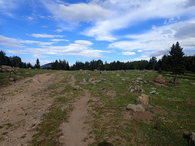
Beautiful scenery, but no 360 degree summit view atop Polvadera Mesa. The reward rests within.
Everyone asks questions about the extremes on the Great Divide Mountain Bike Route. The most mileage. The highest elevation. The longest day. The heaviest rain. The strongest wind. The coldest night. The hottest day. The worst road. The biggest. The baddest. The craziest. The coolest.
Well, alright. Here's the toughest climb, among many hard climbs on the Great Divide. For example, Montana basically is riding up and down one pass just to reach another. Right off the bat is the Whitefish Divide and Red Meadow Divide, then Stemple Pass, Lava Mountain, Fleecer Ridge, Union Pass, and others each deliver some version of nastiness. In Colorado, the climbs generally are longer, more gradual, and better surfaced, but throw down different challenges of higher elevation with more exposure to thunderstorms. There are plenty of tough climbs of all kinds on this route.
However, for me, hands down, the toughest climb on the entire route is the 27 miles from Abiquiu up Polvadera Mesa in the Jemez Mountains of New Mexico. All others can leg wrestle for second place.
It's not obvious on paper. The climb does not ascend a named pass or a big mountain summit. It's not even above tree line. And it doesn't cross the Continental Divide. But it's not only a relentlessly aggressive climb for every inch of the final 12 miles, the terrain actually gets tougher with each successive mile. Of course, there's no town, no ranch, no cabin, no water, not even a stock tank, and no other traffic for any help. You're on your own. No other climb puts it all together like Polvadera Mesa.
Nice gravel gradually climbing from Abiquiu, at least at the beginning.
The night before my climb up Polvadera Mesa, I relax on a bed in a shed at the Retreat On The River outside Abiquiu. After a slow moving morning catching up with text messages over breakfast burritos at Bode's, I finally leave at close to 10:00 am with 2 days of food and a full load of water.
Even on a less than blistering 90-some degree day, that 7 liters of water turns out to be barely enough. If ever riding this stretch again, I would drink as much water as possible beforehand, carry at least another liter of water, and leave a couple of hours before sunrise. It is a long, hard, hot, dry day on the bike.
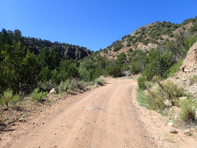
After just a mile of pavement out of Abiquiu, the route turns to good gravel and climbs steadily along Abiquiu Creek. I pass an occasional, well-worn house, but see no people or activity. Even the dogs are quiet in the late morning heat. After about 4 miles I cross Abiquiu Creek, but it's far too early to need water. Know that the next perennial surface water is over 60 rough miles and 7,000 feet of elevation gain away.
Less than another 4 miles farther, the route turns west on USFS Low Standard Road 27 across a dry plateau and climbs directly toward the mesa. This section is about as fast as it gets today, although it's exposed and occasionally soft. I find a warmup rhythm and just a couple miles later, now about 10 miles from Abiquiu, I cross a cattle guard to enter Santa Fe National Forest. I stop to grab a drink, snack, and some shade in the rising heat of the day. Little do I know that the climb is just beginning.
Turning upward into Sante Fe National Forest, the road immediately deteriorates.
Immediately upon entering Santa Fe National Forest, Road 27 "deteriorates," as the ACA cue sheets say. As I have learned, the detailed ACA maps and cue sheets are very accurate on distances and directions, but display an almost comical understatement of difficulty. For example, a notation that an incline is "steep" often is so vertical that I'm pushing the bike at some point. In the case of Road 27, I can see the boundary of the National Forest just by the look of the road. So, yeah, it "deteriorates."
The next 2 miles jump up abruptly and then drop just as much in 3 chunky miles. This short descent is the only one all day, but it's all hands on deck to keep the bike upright through the loose rocks. It certainly is not a relaxing payoff for the first 12 miles of climbing from Abiquiu.
At a little over 15 miles, basically at the bottom of that short drop, Road 27 jolts up with a sweeping turn toward the southwest. I've been riding mostly uphill for well over 2 hours, but the money climb starts now. 12 miles of relentless, increasingly difficult up.
By now, the mid-day sun cooks and the high desert wind dries, so I duck under some shade off-road to prepare body and mind for the task confronting me. By the elevation profile on the ACA map, the next 12 miles look to gain about 3,000 feet at a relatively consistent gradient. If I can settle into a sustainable rhythm, I think I can manage the distance and elevation gain in a few hours, even on this road in this heat.
In Santa Fe National Forest, the road gets rougher, although a short drop lies ahead. To the west is 9,852' Cerro Pedernal, an ancient volcano.
"Sustainable rhythm?" laughs Road 27, "Ha!" This is now an all out assault of punchy pitches through loose rocks, then ruts, then sand, then embedded rocks, and then random combinations of any and all of the above. There's no break, no pause, no relief, in gradient or surface. To keep the bike moving uphill, every pedal stroke is an all out effort, physically, mentally and emotionally.
So, I ride. And, I stop. Repeatedly and frequently, I stop for shade and drinks. Then, I ride. Road 27 is relentless and cruel, taking me directly into the sun as temperatures crank into the 90's. Shade is found only off-road and water is found only in the bottles carried. I begin to wonder if 7 liters of water will be enough.
I spot some hard rock surface and think this could be more rideable, maybe something like Moab slick rock. No such luck. It's hardened lava, or some form of bedrock, with large, irregular lumps and deep depressions often filled with sand. Rhythm is impossible with the constantly changing surface up the steep pitch. I weave back and forth, fighting to pick a line through the obstacle minefield.
The hard rock bed surface comes and goes, connected with stretches of rutted dirt and sand. Eventually, the hard rock surface gives way to simply sand, which at least is consistent. Even in my lowest gear, it's like doing a heavy leg press with every pedal stroke. Meanwhile, the gradient and heat give no quarter.
Clearing the hard rock and sand, the final pitch shifts to loose rocks and ruts.
Finally clear of the worst of the sand, I stop yet again. Throughout the challenging array of surfaces, Road 27 relentlessly, aggressively pitches upward without even a hint of respite. It's just a steady, steep incline up an unsteady, ever-changing primitive road in the searing sun. I earn those 3,000 vertical feet over 12 miles at the barely pedestrian rate of 3-4 miles per hour. That's when I'm moving.
The afternoon slips away, along with most of my water. I need to find the top of this thing soon and then find some water that reportedly lies some miles on the other side. Road 27 cares not. If anything, the gradient increases and the rocks proliferate. My stops grow more frequent, and last longer.
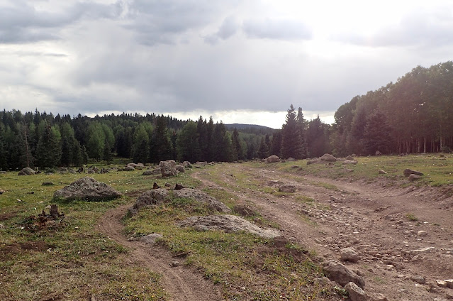
I mark progress in tenths of a mile and look upward for at least a peek of the summit. With no top in sight, I see the signs right beside me, as scrubby brush gradually transition to the beginnings of piñon and aspen forest. I'm getting there. Late afternoon clouds slowly roll in, capping temperatures and suggesting rain. The final, rock-strewn pitch finally t-bones at USFS Secondary Road 144, marking the end of the big climb. I stop to recover, re-fuel, and celebrate.
Pulling out maps and cue sheets, I find myself still 37 miles from the next perennial stream, Rio de las Vacas, although promising Canones Creek is just 8 miles away. I'm down to my last liter of water, so I drink some now and save some for dinner. Even though it's approaching 6:00 pm, I decide to rest for a bit, ride to Canones Creek, and camp there, with or without more water. If need be, I'll find water in the morning when I eventually descend off this mesa.
After topping the climb, I turn onto USFS 144 in search of water and a campsite. I camp in the trees just beyond the clearing on the left.
Comfortable with my situation and decision, I grab an assortment of snacks and plop down against an aspen tree. I'm tired, but not spent. I'm still hot, but not overheated. I'm hungry, but not empty. I realize that all the long days over many weeks made this day not only possible, but enjoyable. I continue to get stronger in body, mind, and spirit. This is good. This is really good.
Some time passes, though I'm not sure how much. Breaking the silence is an ATV chugging up Road 144. The driver spots me and stops to chat. It's Tom, an elk hunter from Georgia who journeys out to Northern New Mexico every year. The elk season starts in two days and he's out scouting. We chat for awhile about elk, other wildlife, and just spending time in remote backcountry.
Eyeing my loaded bike, Tom asks me about my ride and is astonished to hear that I rode up Polvadera Mesa from Abiquiu today. He asks if I need anything, noting that he has a fully stocked camper and a vehicle to easily get supplies. All I really need is water, but I believe I'll find some a little further down the road. "Here, take some of mine," Tom says, as he reaches into a cooler on his ATV and tosses ice cold 750 ml bottles of water to me. Whoa. In no time, I've topped off my standard load of 4 liters, plus a liter for dinner. Trail Angel, indeed. Way up here atop Polvadera Mesa. Amazing.
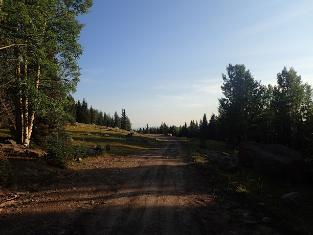
Eventually, Tom drives down Road 144 to the east and I pedal west. This road is not easy at the end of a long day, bumping over rocks and ruts up-and-down across the top of the mesa. But it's not Road 27 and the miles pass with less difficulty. Meanwhile, the sun keeps working toward the horizon, so I pick out a nice dispersed campsite in a little aspen grove and enjoy every bit of sunlight before turning in.
It's a peaceful end to a hard, hard day on the bike, marked by over 7 hours riding up the toughest climb on the Great Divide Mountain Bike Route. I'm grateful for the ability and opportunity to ride yet another day through this country and to meet yet another friendly person. I love this journey.
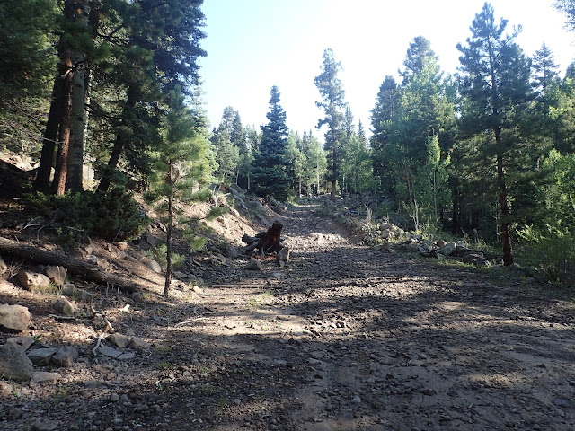
This is early the next day, looking back on the descent off Polvadera Mesa. It's full on mountain bike territory that I'm glad to ride when fresh.
Tuff Enuff, Foo Fighters with Jimmie Vaughan, live on Austin City Limits (2015).
No comments:
Post a Comment