The BackBone Grande is a 400 mile bikepacking route running south to north across the State of South Dakota along the spine of the Black Hills. It's a highlight reel showcasing the best of the Black Hills and surrounding prairie, connected by a unique mix of remote gravel and dirt roads. See, Introducing The BackBone Grande.
Right from the start, the Grande delivers a Great Divide type of bikepacking experience. In the first 46 miles, the route pokes right into the main street of a ghost town, flies across rolling ranch land on graveled county roads, and then dives deeply into primitive National Grasslands on barely built and practically unmarked dirt two track. There awaits water and the freedom of disperse camping. Let's go!
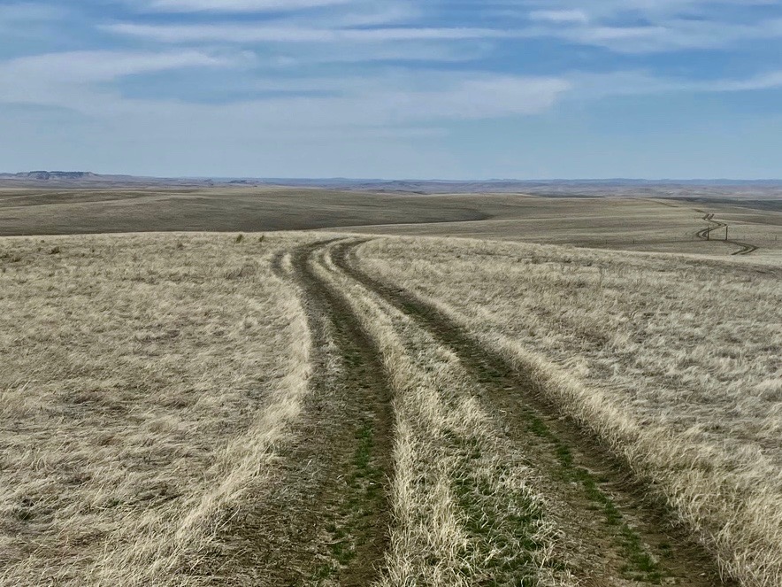 |
| Buffalo Gap National Grasslands, Miles 31-45 of the BackBone Grande. A whole lot of what you see here. |
The BackBone Grande starts at the Nebraska border, just a mile and a half south of the ghost town of Ardmore, South Dakota on paved Highway 71. Don't expect re-supplies here, as the town all but dried up decades ago. Abandoned buildings dot a handful of lumpy streets, punctuated by shells of rusting vehicles scattered across long neglected lots. A closer look reveals some signs of recent activity and a newer volunteer fire building sits on the main street. Perhaps a few people still live here. Or maybe it really is a town of ghosts.
 |
| Crossing into South Dakota, less than 2 miles to gravel. |
That little bit of pavement into Ardmore will be the last for awhile, as the route turns east on county graveled Ardmore Road. This is your rhythm section. Enjoy cruising through 30 miles of sparsely populated, little traveled Western South Dakota ranch country.
Stay alert. I've seen all sorts of critters along that road, including pronghorn, deer, elk, coyote, fox, skunk, prairie dogs, eagles, and hawks. There's more than cattle out there.
 |
| Riding east across rolling ranch land on Ardmore Road. |
At about Mile 30, the BackBone Grande hits U.S. Highway 79 for a mile long jog to Wilcox Road, a county Minimum Maintenance Road that crosses private ranch land with a sign screaming NO OUTLET! If you're riding the Grande, keep riding. In just 2 miles, Wilcox Road accesses Buffalo Gap National Grasslands.
Now, it's no longer a "Minimum Maintenance Road" by the county, but a full-on, two track "Low Standard Road" by the U.S. Department of Agriculture. Ahead lies twelve miles of rough road nirvana to Limestone Butte Reservoir.
 |
| In just a few miles, MMR Wilcox Road enters Buffalo Gap National Grasslands. Disregard the "NO OUTLET" sign. Where we're going, we don't need outlets. |
Oh, my.
Wilcox Road abruptly turns into the much rougher Buffalo Gap National Grasslands Low Standard Road 7026. This is amazing. Barely built, soft dirt two track rolls across primitive prairie, with big views all around, hinting of the distant Black Hills on the horizon. This landscape instantly transports you into a different world, far away in time and space. Civilization fades into the distant past.
Road 7026 is a public road on public lands that initially crosses into, and out of, pockets of private land. Open and close the occasional cattle gate as you pass through. If you can't tell from the signs or don't have a detailed map to identify private land, just stay on Road 7026 until about Mile 36, when you see some water tanks and pass through another cattle gate. From there on to Limestone Butte Reservoir at Mile 44, you're completely in Buffalo Gap National Grasslands, with practically unlimited disperse camping.
 |
| Several cattle gates over the 12 miles on BGNG Road 7026 to Limestone Butte Reservoir. |
Road 7026 bumps along ridge lines and crosses ravines. Nothing long or steep, but it is starkly exposed to the elements. More bluntly, there are no trees or other source of shade, cover, or wind break. And there is no surface water, other than a string of cattle tanks and two small reservoirs of Bennett Main Dam (0.7 miles off route at Mile 41) and Limestone Butte Reservoir (Mile 44).
It is not well marked. Better stated, there are very few signs of any kind. In addition, over the course of 12 miles, many two tracks meander off Road 7026 and very few of those intersections are marked. In general, Road 7026 is the most "developed" two track, at least until it runs into Road 7022 at about Mile 39. At that spot, there's a cattle tank and Road 7026 takes a 90 degree turn north, while more heavily traveled Road 7022 goes straight east. I found my way with a paper map and compass. For the digitally dependent, I created a map that is publicly available on RideWithGPS. Just pay attention.
In any event, the area is not large. Two well developed roads (U.S. Highway 79 and FRC 3S), just 10 miles apart, run parallel to each other and frame the western and eastern boundaries of this area. So, it's not hundreds of miles to civilization. It just looks like it. And feels like it.
 |
| One of the few signs marking BGNG Low Standard Road 7026. |
For this post, I scouted Road 7026 in the second week of April 2023, a little over a week after it received a foot of snow. It was bone dry, soft, and almost powder-like in spots. With a little rancher traffic and some heat, I suspect that dirt will harden significantly. In any event, if loaded for bikepacking, I would ride my Jones 29+ mountain bike with 2.35 inch tires.
If wet, Road 7026 would be an entirely different beast. If windy, hang onto your helmet. If hot, mind your water. Over time, this stretch will create memorable challenges. I can't wait to hear the reports.
 |
| Big views to the North, with a bit of the Black Hills on the horizon. |
Disperse camp most anywhere in the National Grasslands and filter water at the reservoirs or cattle tanks. For a slightly more refined experience, continue north from Limestone Butte Reservoir on Road 7026 for about 2 miles to paved U.S. Highway 18 and then about 3 miles west to the small rodeo town of Oelrichs (about a mile off-route). Oelrichs offers a moderately stocked C-store, two bars, and a primitive, self-service RV park.
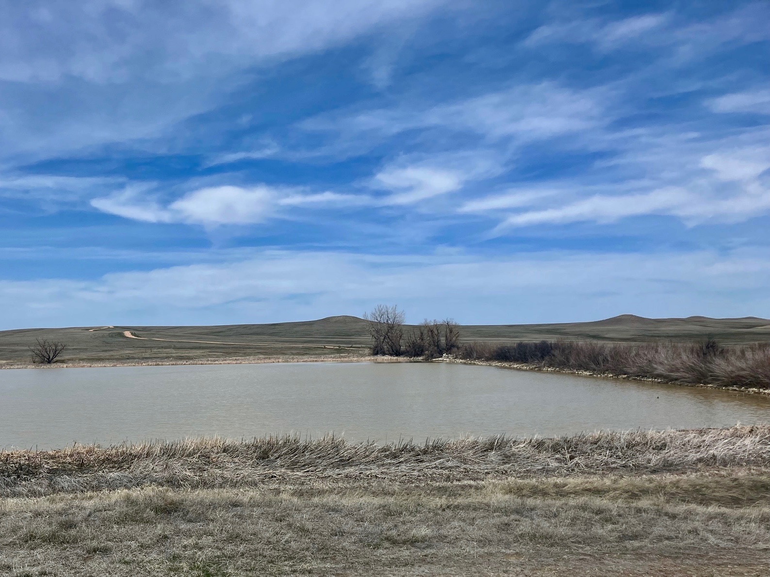 |
| Limestone Butte Reservoir at Mile 44 for disperse camping. |
Welcome to South Dakota on the BackBone Grande! These early miles are unlike anything else around and feel like a glimpse into the Great Basin on the Great Divide Mountain Bike Route. But it's uniquely Buffalo Gap National Grasslands and it's your beginning of the BackBone Grande.
Know that many more gems lie ahead.
Next up. Through Buffalo Gap into Wind Cave National Park and Custer State Park en route to the full service town of Custer.
For an earlier, related post, see Introducing A Bikepacking Route - The BackBone Grande. For a digital map, see BackBone Grande Digital Map.
Oh, oh, oh. The best riding !
ReplyDelete