Search This Blog

Monday, February 27, 2023

Taste of Black Hills Gravel

This time of year seems to generate questions about gravel routes, from both locals and travelers.

For stellar day rides on forest gravel roads in the Black Hills of South Dakota, start with the "Routes & Resources" page of BlackHillsGravel.com. Lucas Haan, our local Pied Piper of Gravel, has archived a library of routes from the popular Black Hills Gravel Series. Every route there is worth riding.

The Black Hills Gravel routes are categorized by color to indicate their relative distance and difficulty. "Green" routes are the shortest (10-15 miles) and least difficult (better surface, less climbing, simple navigation). "Blue" routes are longer (25-35 miles) and a bit more difficult (some rougher surfaces, some more climbing, a bit more remote). "Black" routes are the longest (45-55 miles) and more difficult (stretches of rough roads, maybe a Low Standard or single track connector, steeper climbs and more elevation gain). In general, a given Green, Blue and Black route are nested from a common start/finish town or commercial establishment.

RideWithGPS is notoriously inaccurate with its "Paved Surfaces" notation.
Disregard it. This route is practically all gravel and dirt.


One of my favorites from this library is the 2017 Rochford Black Route (49 miles/3,600 feet of elevation gain). Starting and finishing in the quaint mountain town of Rochford, this route includes the pot-holed, often muddy, Low Standard road climb along Castle Creek, a rocky spur up abandoned Flag Mountain Lookout for 360 degree views, a curvy drop down Black Fox Camp Road, and a flying descent on South Rapid Creek Road. See, 2017 Rochford Black Route.

I rode that route in the 2017 Black Hills Gravel Series and highly recommend it. Before that and since then, I've ridden all those roads many times as part of other rides. I've even included many of those miles on several routes I have created, such as the Black Hills BackBone, 2021 Black Hills Bounty, Heart of the Hills Overnighter, and BackBone Grande. They never get old.

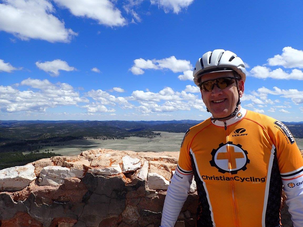
All smiles atop Flag Mountain Lookout on the Rochford Black Route.
2017 Black Hills Gravel Series. (photo by Heather Heynen)

For what it's worth, if I were to ride that particular route now, I would ride it counter-clockwise, rather than clockwise, for three reasons.
  • Although the Black Fox Camp Road is top notch either way, I prefer riding it uphill, rather than down. The climb isn't steep and I enjoy soaking in the views of steep cliffs, a meandering stream, dense cover, and the occasional beaver dam. It all seems to go by too fast when riding downhill.
  • In contrast, I prefer to ride Castle Creek Road downhill, even though it's a nice climb, too. That Low Standard Road is rocky enough, and often muddy enough, to check my speed and I don't seem to miss as much as the downhill on Black Fox Camp Road.
  • When turning off Castle Creek Road onto Mystic Road, I would hop on the Mickelson Trail for the final 7 miles. I normally prefer roads, but the Mickelson Trail here avoids some traffic and sharp corners on that gravel road into Rochford and, as a bonus, passes through a tunnel.
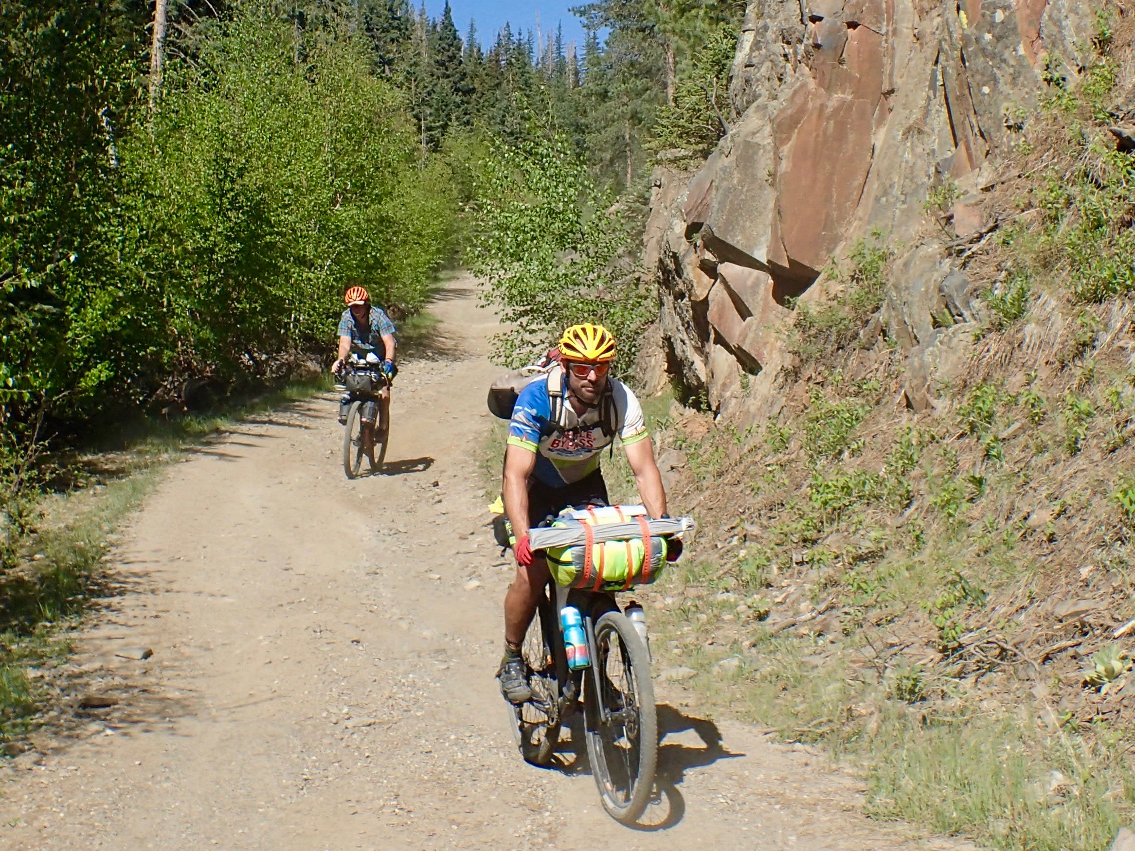
Ben Cooper and Paul Brasby navigate Castle Creek Road at the 2021 Black Hills Bounty.

Black Fox Camp Road. Simply the best.

So, start with the "Routes & Resources" page on BlackHillsGravel.com. But don't be afraid to pull out a map and look for other interesting roads. A lifetime of back road riding awaits in the Black Hills.


Sunday, February 12, 2023

BackBone Grande - To The Start & From the Finish

A logistical issue inherent with a cross-state cycling route is getting to the start and from the finish. Make that state South Dakota and that route on back country gravel/dirt roads and both are sure to be well removed from anything resembling a population center.

Well, the southern terminus of the Great Divide Mountain Bike Route is Antelope Wells, New Mexico, a closed U.S. Border Station 45 miles away from the nearest town of Hachita (population 49). Self-sufficient bikepackers on the Great Divide figure it out. I'm sure that anyone embarking on a ride of the BackBone Grande will, too.

Nonetheless, since South Dakota is largely unknown to many, here are some specifics of the start and finish of the BackBone Grande to kick start things. Introducing the BackBone Grande.

There's prairie to cross, both North and South of the Black Hills, on the BackBone Grande.

1. Drop Off at the Start & Pick Up at the Finish
A simple approach requires another to drop you off at the start and pick you up at the finish. The RideWithGPS file should direct your driver to both the start and the finish, which are accessible via paved roads and all-weather gravel roads. Yes, both will be a bit of a drive from the nearest coffee shop or pub.

2. Ride to Connect at the Nearest Town
One can ride to the start and from the finish to connect with your driver at the nearest town. The southern terminus of the BackBone Grande lies about 30 miles south of Edgemont (population 725) and about 34 miles southwest of Hot Springs (population 3,400). The northern terminus lies about 43 miles north of Buffalo (population 350). Your driver can access all three of these towns on paved highways.

3. Ride Directly from/to Rapid City
One can ride directly from Rapid City to the start or to Rapid City from the finish, presumably for a flight or other public transportation elsewhere. That's about 90 miles from the Southern terminus and 150 miles from the Northern terminus.

4. Ride Back to the Start on the Grande Route
Every year, some adventuresome folks yo-yo the 2,500 mile Great Divide Mountain Bike Route. That is, they ride the entire route one direction and turn around to ride it all the way back. Why not the 400 mile BackBone Grande? That actually sounds like a great ride.

5. A Different Return Route for One Big Bad Loop 
I'm working on a unique route that starts at the Northern terminus of the BackBone Grande and loops southward back to the Southern terminus. As currently envisioned, this BackBone "Double Grande" would be a much different experience from the Grande. More rough roads. More remote. More distance between re-supplies. More dispersed camping. More self-sufficient. Likely a swing through parts of Montana and Wyoming. This will take some time to do right. Perhaps next year I'll be ready to publish it. Of course, in the meantime, you can always create your own return route.

6. Support/Shuttle Vehicle Shadow
The entire BackBone Grande route cannot be driven by motor vehicle. However, the sections that are not accessible to motor vehicles are relatively short. With a little planning and communication, a support/shuttle vehicle should be able to meet cyclists off and on every day, if that's your jam. In other words, you can bring your shuttle to the finish with you.

7. Open to Imagination
Possibilities are limited only by your imagination. Say a friend wants to join for an overnighter, but not more. Leave a shuttle vehicle at the start and that friend can ride back to retrieve it on Day 2 while you continue on the route. That process could also be employed in reverse from the finish.

The prairie takes no prisoners.

The start and finish of the BackBone Grande are only about 250 driving miles apart, with Rapid City roughly 2 hours from the southern terminus and roughly 3 hours from the northern. 

"No problemo," says the experienced bike packer.


Sunday, February 5, 2023

Today & Tomorrow

Note to self. Go ride. Just ride.

All of December and into the new year, life busted my chops. I'm still staggering. One result was that I did not ride a bike for almost 7 weeks. Not surprisingly, I gained weight, lost fitness, and, worse, cared not.

Then one morning, no different from any other, I dressed up to ride, for no discernible reason. I rode a modified version of my old work commute to downtown, adding to a paved bike path ride a mix of single track, dirt, grass and gravel. Once started, I kept pedaling and eventually rode 16 miles over 2 hours.

Therapeutic. And a nice reminder.

Every day matters. Every ride matters.

Sunny winter day along the Rapid City bike path, with M-Hill in the background.

For twelve years, I rode my bike about 5 miles to and from work practically every day, year around. I had no larger agenda; not training, not spending less on gas, not saving the planet. I just loved that I could ride my bike twice every day. A Final Commute.

Any given day, it was not apparent how such a short, low level effort would make much of a lifestyle difference. However, I loved the ride, felt better all day, and unknowingly built a physical and mental base for the inevitable big rides in the future. Eventually, I realized that little bit of consistent daily movement over time produced significant health and fitness gains. Physical and mental.

Riding past Little League baseball fields always brings a smile.

Three weeks have now passed since that reminder bike ride. Other than a day spent shoveling piles of snow and another day committed to family matters, I have ridden some variation of that route every day since. Most days I cover those 15-16 miles in about 2 hours on my loaded Jones mountain bike, although sometimes it's an easy 90 minute spin and sometimes a hard 3 hour grunt. But I've been out there, living a lesson deeply engraved from the Great Divide. Living A Dream.

Enjoy the day, with everything that comes with it, and give yourself a chance to ride tomorrow.

Ride today. Ride tomorrow.
That today had no snow. Tomorrow this may be a trail.


Sunday, January 29, 2023

Black Hills BackBone, DoubleBackBone & Grande

My introduction of the Black Hills BackBone Grande route prompted many questions about the differences from my older Black Hills BackBone and DoubleBackBone routes. The BackBone Grande. Fair enough.

The BackBone and DoubleBackBone = designed for long gravel rides, but can bikepack it. 
The BackBone Grande = designed for multi-day bikepacking, but can continuous ride it.

Of course, there's much more to that story. The BackBone Grande draws from a deeper data base built on 10 years of back roads exploration in the Black Hills and unforgettable experiences of multi-day and multi-week bikepacking rides across the Mountain West. It takes cyclists to more memorable places, both well-known and obscure, on a wide variety of challenging roads. It's a different beast.

If you're looking for USFS Low Standard Roads, the Black Hills are full of them.

Back in 2014, I created the BackBone as a solo, self-supported, light and fast gravel ride. At 310 miles and 19,700 feet of elevation gain, it certainly pushes the limits of a long, continuous ride for most cyclists. But with straight forward navigation, 200 miles of Primary Roads, and 35 miles of pavement, the BackBone rides relatively fast. Low Standard Roads, the rough ones that really take it out of you and take you further out there, account for just 7 miles, or about 2%, of the BackBone.

USFS Secondary Road 189 southbound down Flag Mountain.
The signature image of the Black Hills BackBone.

In 2017, I then created the DoubleBackBone as an opportunity to ride the BackBone southbound and then return to North Dakota on mostly different roads. However, the overall road makeup is much the same. At 330 miles and 17,900 feet of elevation gain, the DoubleBackBone also rides relatively fast, with straight forward navigation, 238 miles of Primary Roads, and 38 miles of pavement. Low Standard Roads are less than 16 miles, or about 6%, of the DoubleBackBone.

Mostly on well developed gravel roads, the BackBone and DoubleBackBone are certainly suitable for loaded touring, if that's your jam. That's just not why they were created. 

USFS Low Standard Road 383 northbound to Gillette Canyon.
The signature image of the Black Hills DoubleBackBone.

After bikepacking throughout the Black Hills and across the Mountain West the past several years, I decided to design a new route specifically for a Great Divide type of bikepacking experience. For me, that means 50-100 mile days on a loaded touring bike over back roads with significant climbing, more navigational challenges, more rough roads and rougher roads, a mix of re-supply and sleeping options, more natural and human-made sightseeing, both well known and obscure, and a few fun Zero Day opportunities. A much different experience.

The BackBone Grande is my take on that type of bikepacking route, featuring many miles of rougher roads with popular sights and little known gems along the way. This route will take you to many places the BackBone and DoubleBackBone do not. Those that have ridden my Black Hills Bounty routes will catch a similar vibe on the BackBone Grande.

And it's not all back country. For a short break during a long, remote bikepacking ride, I added some pavement across Spearfish to hit both bike shops, an assortment of restaurant and re-supply options, and lodging, including the popular city campground. Also, from Custer and from Hill City, I added optional, off-route, mostly paved loops to Mount Rushmore, Sylvan Lake, Needles Highway, and Iron Mountain Road. No sense rushing a vacation.

The Black Hills are beautiful. Most any combination of roads winding through the Black Hills will be a beautiful ride. But there is a difference between better and best. The BackBone Grande covers what I consider to be the very best of our Black Hills and surrounding prairie in a cross-state ride.

Lame Johnny Road westbound into the Black Hills.
The signature image of the Black Hills BackBone Grande.
(image by Kevin Fox)

At a touring pace of 55-65 miles per day, it will take 6-7 to complete the 400 mile BackBone Grande, plus another day for an optional Mount Rushmore loop. Some will certainly ride it faster. Others may even attempt to through-ride it, although I don't recommend it. This is one to soak in. Besides, who wants to T-bone a large mammal at night while settled in aerobars and staring bleary-eyed at a power meter. 

The BackBone Grande is a remote, rough road route for self-sufficient, experienced bikepackers capable of successfully riding through sparsely populated backcountry with spotty, if any, cell coverage. You're on your own out there. Enjoy it.

USFS Low Standard Road 530.1A.
A piece of the 58 miles of Low Standard Roads on the BackBone Grande.

Here is an approximate breakdown of the roads on the BackBone, DoubleBackBone, and BackBone Grande. Perhaps the most simple comparison of these routes is the total miles of Low Standard roads. BackBone = 7 miles. DoubleBackBone = 16 miles. BackBone Grande = 58 miles. Another comparison adds the Low Standard and Secondary roads. Backbone = 75 miles. DoubleBackBone = 44 miles. BackBone Grande = 138 miles. The Grande is a different beast.

For a description of Primary, Secondary, and Low Standard roads in the Black Hills, go to my prior post. The Good, The Bad & The Ugly.

BackBone - 310 mile/19,700 feet gain (BackBone Map)
65% - Primary (200 miles)
22% - Secondary (68 miles)
11% - Paved (35 miles)
2% - Low Standard (7 miles)
0% - Single Track (0 miles)

DoubleBackBone - 330 mile/17,900 feet gain (DoubleBackBone Map)
72% - Primary (238 miles)
11% - Secondary (38 miles)
11% - Paved (38 miles)
6% - Low Standard (16 miles)
0% - Single Track (0 miles)


BackBone Grande - 400 mile/23,800 feet gain (BackBone Grande Map)
53% - Primary (210.5 miles)
20% - Secondary (80 miles) 
15% - Low Standard (58 miles)
12% - Paved (48 miles)
< 1% - Single Track (1 mile)


Sunday, January 22, 2023

The Good, The Bad & The Ugly (updated)

The way back to town is only 70 miles. If you save your breath, I feel a man like you can manage it.
Blondie encouraging Tuco, The Good, The Bad & The Ugly (1966). 


The United States Forest Service (USFS) categorizes the roads within its boundaries as "Primary Routes," "Secondary Routes," or "Low Standard Routes." That's it. Just three categories for the staggering variety of roads in our national forests.

Well, it's a start. Here's a USFS graphic introducing each category of Forest Service roads.

As an introduction to understanding these categories of roads in the Black Hills National Forest, here are some of my general observations, with representative photographs. Whatever the USFS calls them and however I describe them, every road in the Black Hills will deliver a variety of riding conditions and challenges that change over time. Your eyes on the road and tires on the ground are the best way to know these roads.

Note that the USFS manages extensive logging operations in selected parts of the Black Hills. In large part, that's why most of these roads exist. Yield to all traffic out there, but especially the big logging trucks. And be thankful to be able to ride on the seemingly unlimited roads resulting from their work.


The Good (USFS Primary Route)

The most developed non-paved road in the USFS system is the Primary Route, which is designed, built, and maintained for year around, regular travel by standard passenger cars. In the Black Hills, the surface of these roads typically is moderately graveled, hard packed local dirt and limestone that drains water well, and generally does not instantly clog, at least not like Iowa top soil, Nebraska talc, or Oklahoma clay. Some roads are treated with Magnesium Chloride, which hardens and stabilizes the surface.

Primary Routes generally are wide enough for opposing motorized traffic to pass easily. If enough gravel exists to form tracks, there would be three or even four. Often a small shoulder will accumulate a bit more gravel that has been pushed off to the side. Relatively high speed vehicle traffic may create washboards and pockets of loose gravel in spots, especially around curves and corners.

My ride of choice for Primary Routes is my Alchemy Ronin Titanium gravel bike or my Black Mountain Cycles Monster Cross bike, set up with 40 mm Schwalbe G-One tires. Even when loaded for multi-day bikepacking, these gravel bikes provide plenty of support and control to comfortably ride all day. Relatively speaking, Primary Routes are fast.

On USFS maps and signage, a Primary Route is designated by brown sign with a number enclosed in a rounded corner, isosceles trapezoid having the longer parallel side on top, as shown below for Boles Canyon Road (117). 


The following photographs are representative of USFS Primary Routes in the Black Hills.


The Bad (USFS Secondary Route)

The next level of developed, non-paved roads in the USFS system is the Secondary Route, which is maintained for high clearance vehicles. In the Black Hills, USFS Secondary Routes typically are similar in composition to Primary Routes, that is, hard packed dirt and limestone that handles water well and does not overly clog. However, the surface may be even less graveled, or just occasionally graveled, or not graveled at all. Almost certainly, it will not be treated with Magnesium Chloride. Foremost, that means Secondary Routes are more susceptible to mud when wet and ruts when dry.

Due to less maintenance, Secondary Routes also sport occasional loose dirt, exposed surface rock, pot holes, standing water, and fallen timber, while presenting sharper turns, steeper gradients, and shorter sight lines. Also, Secondary Routes typically are two tracks wide, often with little to no shoulder. If a motorized vehicle approaches, I typically pull off the road to allow it to pass. For logging trucks, I definitely leave the road.

All that being said, many Secondary Routes in the Black Hills are passable in dry conditions in passenger cars, if attentive to occasional obstacles and clearance issues. For example, I confirmed my cue sheets for the entire Black Hills BackBone route driving my 2006 Chevrolet HHR, hardly a high clearance vehicle. Over the 310 mile route, with many miles of Secondary Routes, I maneuvered around a few high-center issues and only had to skirt one fallen tree blocking the road. These roads can be fast, but stay alert.

My ride of choice for most Black Hills Secondary Routes is still one of my gravel bikes with 40 mm tires. These roads may be rougher and mountain bike type gearing may be helpful in spots, but most of these roads are developed enough for me on a gravel bike. On the other hand, if loaded for a multi-day ride with significant miles of Secondary Routes, I may well opt for my Jones 29+ mountain bike with bigger tires.

On USFS maps and signage, a Secondary Route is designated by a three or four digit number enclosed in a brown, rounded corner rectangular sign, as shown below for Williams Draw Road (691).


The following photographs show three USFS Secondary Routes in the Black Hills.


The Ugly (USFS Low Standard Route)

The third level of developed, non-paved road in the USFS system is the Low Standard Route, which is unimproved and not maintained for automobiles. The Forest Service recommends travel by vehicles with both high clearance and four wheel drive. I would add driver prudence and experience.

Design, construction, and maintenance of Low Standard Routes are all over the map, even along a single numbered road. Some sections may be soft dirt, while others are rock gardens. If wet, standing water and mud can be a real issue, leaving deep ruts when dry. Maybe a load of chunky rock was dumped to stabilize a low spot, or maybe not and there's a stream to ford. They are rough, sometimes little more than a bull dozed logging trail. For me, this is mountain bike territory, for tires and gears, even unloaded, for anything more than a short connector.

Many, many, many Low Standard Routes are dead-end spurs that were built to get to a spot for logging. Maybe some spurs later connect to something else and haven't made it on a map, or maybe not. I often refer to the USFS Motorized Vehicle Use Maps, which are updated every year and prove to be pretty accurate. However you navigate, count on no cell coverage and no passing traffic of any kind. You are on your own.

If you like this kind of riding, the Black Hills offer a lifetime of miles to explore.

On USFS signage, a Low Standard Route is designated with a three-digit number vertically imprinted on short, 4 inch wide, brown carbonite post. On USFS maps, it's just a plain three-digit number. The designation of any road emanating from that Low Standard Route adds a decimal and another number. For example, in the Black Hills, USFS 278.1 runs off of USFS 278. Then, any roads running off of USFS 278.1 get letters, the first being USFS 278.1A, then 278.1B, and so on. It can be confusing in the field and USFS map navigation is an entirely separate subject. Just know that any carbonite USFS road sign with a three-digit number, or with decimal numbers, or with letters, identifies a Low Standard Route.

Shown below is a sign for Low Standard Route 242, and then one for Low Standard Route 325.1D.


The following photographs show a sampling of USFS Low Standard Routes in the Black Hills. I captured all of these images while out riding, with the sole exception of the last photograph, which Lucas Haan provided as an example of a deposit of chunky gravel. I included more photographs of Low Standard Routes because of their great variety.


To wrap this up, here's a fun rendition of Ennio Morricone's 1966 composition of music for the movie "The Good, The Bad And The Ugly," performed by the Danish National Symphony Orchestra in 2018.

The Good, The Bad And The Ugly, Danish National Symphony Orchestra (2018)