The BackBone Grande is a 400 mile bikepacking route running south to north across the State of South Dakota along the spine of the Black Hills. It's a highlight reel showcasing the best of the Black Hills and surrounding prairie, connected by a unique mix of remote gravel and dirt roads. It's a Great Divide type of bikepacking experience right here in my backyard. See, Introducing The BackBone Grande.
Picking up the route from Buffalo Gap National Grasslands at Mile 46, the BackBone Grande turns onto 2 miles of pavement on lightly traveled U.S. Highway 18. A limited re-supply opportunity lies just 1 mile off-route to the west in the small rodeo town of Oelrichs, which offers a small, but moderately stocked C-store, two bars, and a primitive, self-service RV park.
 |
| Buffalo roam free throughout Wind Cave National Park and Custer State Park. |
Then, it's generally north through rolling ranch land, hopscotching the small towns of Smithwick, Oral, and Buffalo Gap. These roads carry some local traffic, so they can have more gravel, some washboard, and even pot holes. A few residents occupy these towns, but the only commercial establishment is the Buffalo Gap Trading Post, which offers a bar with refreshments but little else.
Although this land shows more human activity than the ghost town of Ardmore, many small cemeteries mark the pioneers' time and toil here over the years. It's a harsh life on the prairie.
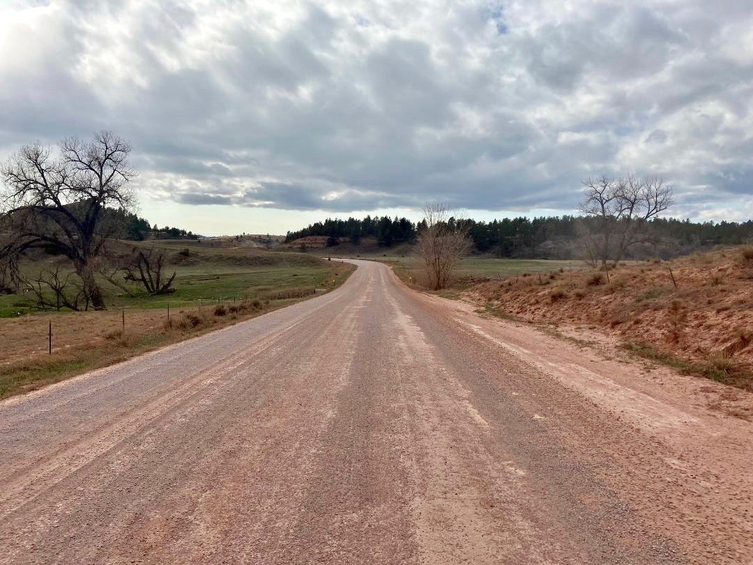
 |
| Fall River County Road 6291 crossing the Cheyenne River en route to Buffalo Gap. |
At the town of Buffalo Gap (Mile 74), the BackBone Grande turns west on Fall River County 7-11 Road to wind up Beaver Creek into the Black Hills through "buffalo gap." When buffalo freely roamed the Great Plains, those around these parts would move up from the prairie through this gap to winter in the more sheltered forested hills. Just imagine thousands and thousands of buffalo making their way up this narrow valley.
7-11 Road is a well developed, well traveled county road across private land, with more than the average amount of traffic, at least for gravel roads in the Southern Black Hills. But it's historic, scenic, fast, only 5 miles, and, importantly, it's our entry into the Black Hills through Wind Cave National Park and Custer State Park.
 |
| Fall River County 7-11 Road looking west toward the buffalo gap. |
Now, we're diving in the deep end. Turning off 7-11 Road onto Red Valley Road (Fall River County 5), the BackBone Grande ventures north past a couple of cattle ranches before entering Wind Cave National Park. Just to the west, the hills bump upward toward higher elevations and dense stands of pine trees. This is buffalo country.
I ride into Wind Cave National Park at least a couple of times every year and see buffalo every time. Every single time. Stay alert. Keep your distance. Check your speed. If you see cinnamon colored calves, increase your distance and decrease your speed. Stop, if appropriate. And always look for that one, big, solitary bull, separate from all the rest, who watches and protects the whole herd. These are wild animals, as fast and quick as a horse, but much bigger and with horns. Not to be underestimated.
 |
| Public Service Announcement from the National Park Service. |
Riding north over Boland Ridge, the rough dirt road NPS 6 drops directly into Custer State Park, where even more buffalo roam. The paved Wildlife Loop is a tourist favorite that passes the Buffalo Corrals, where the State Game, Fish & Parks conducts an annual, very popular Buffalo Roundup in late September. It's worth returning just for that. There's nothing quite like witnessing 1,300 buffalo thundering over a ridge toward you. See, Buffalo Roundup.
About 2 miles up the Wildlife Loop, the Wildlife Station Visitor Center (Mile 89) offers water, bathrooms, shade, and a few refreshments in a vending machine. Not much, but it's a nice break after 15 miles of generally shadeless uphill since Buffalo Gap.
 |
| NPS 5 looking toward Boland Ridge and then Custer State Park to the north. |
Time to climb a little up Lame Johnny Road and then over to Fisherman Flats Road. Both are good gravel roads that wind through Custer State Park for tourists to venture a little bit more into the back country. But it's not heavily traveled, at least not by cars. Buffalo still roam this transitional area from prairie to forest, as do pronghorn, deer, and even elk.
As Fisherman Flats Road reaches into the forest, the BackBone Grande peels off onto Custer Trail 1. Although called a "trail," Trail 1 is a fun, little two track that skirts a few ridges for about 3 miles to reconnect with Lame Johnny Road higher up. Nothing like a little known, little traveled old road to dive a little deeper into the Black Hills.
A quick descent bottoms out at French Creek Horse Camp (Mile 99). This is a very popular state park campground, and may be full, but there's always water, bathrooms, shade, and a friendly campground host. There almost certainly will be horses all over. Tread lightly.
 |
| Trail 1, a two track traverse in Custer State Park. |
A steady climb out of French Creek Horse Camp tops out by paved U.S. Highway 87, with Blue Bell General Store and Blue Bell Lodge (Mile 102) for some re-supply, meals, and possible lodging. A half mile later, a picnic area parking lot leads to a pedestrian bridge revealing barely recognizable single track heading north. This unmarked single track path can become a bit overgrown, but generally follows along French Creek without crossing it.
In less than a mile, this little gem enters Black Hills National Forest, for possible disperse camping. It then connects to USFS Low Standard Road 408 to reach Hazelrodt Picnic Area and graveled USFS Lower French Creek Road 342.
One final pitch up rough USFS Low Standard Road 341 reaches a rocky ridge with views of the Cathedral Spires, a collection of granite spires drawing rock climbers from all over. Then a bouncy downhill lands on a paved bike path paralleling U.S. Highway 16A for a short cruise into Custer.
 |
| Yes, that's the BackBone Grande route, at least for about a mile. |
County gravel, National Park Service dirt, pavement, State Park gravel and two track, barely single track, Forest Service Secondary and Low Standard Roads, and a paved bike path. Much of it through free roaming buffalo country. All in 68 miles.
That's the BackBone Grande (Miles 46-114) from Buffalo Gap National Grasslands to Custer, through Wind Cave National Park and Custer State Park, with a few choice connectors. You're now in the Black Hills.
Next up. A Greatest Hits Album of Black Hills back roads. Deep into the Heart of the Hills on the renowned Mickelson Trail for views of Crazy Horse Memorial and later through tunnels, favorite Forest Service back roads spiked with granite outcroppings crawling with marmots, big views of 7,242' Harney Peak, the highest peak east of the Rockies and west of the Alps, a restored gold mine, iconic Moonshine Gulch Saloon, and both Castle Peak Road and Black Fox Camp Road to top out at historic Cheyenne Crossing. Best of the best.
For earlier, related posts, see Introducing A Bikepacking Route - The BackBone Grande; (Miles 0-46) - Buffalo Gap National Grasslands. For a digital map, see BackBone Grande Digital Map.
Traffic on 7-11 road is much better now. It was the detour into Hot Springs last summer for large vehicle traffic while they rebuilt the HWY entering Hot Springs from HWY 79. Our large bulk tankers had to use 7-11 to deliver the cement powder they used for the rebuild!
ReplyDelete