That's not a resolution, but a mindset. That's not a lofty goal to hopefully attain someday in the fuzzy future, but an attitude to carry every day.
Today. Right now. On this ride.
That's what struck me during my first gravel ride of the year.
I can be this. Right now.
F.I.T.
A little windy at Wind Cave National Park.
Last weekend, I rode out of Buffalo Gap into Wind Cave National Park on a favorite remote road that actually is on the Black Hills BackBone route. It's a great winter ride because it's out-and-back starting mostly uphill and north bound into prevailing arctic winds. Regardless of the season, I ride past herds of buffalo on this gravel road every ride through Wind Cave. Every single ride.
How many roads guarantee more buffalo than cars?
On this day, the sun shines brightly at 53 degrees as I spin out of the Buffalo Gap Trading Post for my much anticipated first gravel ride of the year. Turning west out of town, however, howling winds rudely greet me, dropping my cadence and speed. Welcome back to gravel, buster.
When a gust of wind lurches my bike a couple of feet off line, the thought of turning back crosses my mind. Hey! Where did that come from? I never have thoughts like that. It's just a little wind.
I slow for a moment, but pedal on. The wind shifts, as it will. I settle into the rhythm of the ride, but that unsettling thought of turning back keeps resurfacing. Where did that come from? That question soon filters down to something different. Why am I out here?
First gravel ride of the year into Wind Cave National Park. Stout winds, hills, rough roads and insight ahead.
The road winds toward that small herd of buffalo in the background. Of course, a curmudgeon or two take the road.
Well, that's not complicated. I'm out to rejoice in the day the Lord has made. That is, to have fun.
That's when I realize that I'm having fun right now. The ambient conditions don't get to decide. My speed and distance don't get to decide. My level of conditioning doesn't even get to decide. I decide to have fun right here, right now.
The wind? I'm sure it will be faster and easier once I turn around for the tailwind cruise back to the Jeep. But more fun? It's fun right now riding directly into it, finding a way to push and pull that crank to turn that gear to move that bike through it. Now, it's uphill, too? Cool. The gravel a little soft? Well, all righty then.
It's fun to work though something to resolution. It's fun to overcome an obstacle. It's fun to do something you're not sure you can. And as my Dad coached me from a young age, it's always fun to get better. The Best Coach I Ever Had.
As the miles roll by, it's easy to drift into anxious thoughts of future events or negative thoughts of past conditioning now lost. Another time perhaps those thoughts can be channeled to something productive. Right now, on this ride, it's time to stay in the moment. Embrace this moment for all that it is.
As time passes, it takes some work to stay in the moment, resolve challenges and be positive. I think that's where mental toughness comes into play. It's easy to get bogged down in other stuff, but, once again, it's not complicated.
Stay in the Moment. Resolve challenges. Be positive.
In the end, and even during the ride, that all adds up to fun.
That's why I'm out there.
Remote road gravel in Wind Cave National Park, Black Hills of South Dakota.
One of my favorite stretches of gravel road anywhere. Yes, it's on the Black Hills BackBone route.
The Black Hills BackBone is simply a bicycle route that I created to ride myself. There is no Black Hills BackBone race, or publicly organized event, or "Grand Depart," or anything like that. It's just a route I created to ride myself. Then I created this blog to document my journey, in part as a digital scrapbook and in part to share my experience with others. That's it.
The tall, broad shoulders of Flag Mountain reveal the granite peaks of Mount Rushmore and Harney Peak.
But, oh, what a route. Inspired by the cross-country routes of the TransAmerican Trail and the Great Divide Mountain Bike Route of the Adventure Cycling Association, I wondered whether I could piece together a remote road ride on primarily gravel and dirt roads that spanned the height of the State of South Dakota along the spine of our beloved Black Hills. That whimsical daydream led to many hours of scouring maps, scouting back roads and pedaling all over Western South Dakota. There seemed to be no end of options. I struggled with this route, primarily because the Black Hills National Forest offers a staggering number of amazing roads to ride. Scouting a promising road invariably led to more. At some point, I simply had to stop, prioritize, and choose. The Black Hills BackBone is the result. Black Hill BackBone - Cue Sheets & Other Links.
Earlier this year, over a cold, rainy Memorial Day weekend, an intrepid group of eight cycling enthusiasts from Colorado made a run at the Black Hills BackBone. On that particular weekend of difficult conditions, they rode about as much of the route as one reasonably could. They said they had a great time, particularly Day 3 from O'Neil Pass to Custer, and vowed to return to the Black Hills. New Friends On The BackBone.
To my knowledge, the entire Black Hills BackBone has not been ridden on a bicycle as a continuous, unsupported, solo ride. In my first attempt in 2015, I stumbled into ferocious prairie winds with horizontal rain that eventually spit me out in Spearfish 135 miles later, barely able to stand. A Rancher's Kindness. In my second attempt in 2016, I flew across the 135 miles of Northern Prairie in ideal conditions before plowing into a freak ice blizzard climbing O'Neil Pass, dropping me into a trail head outhouse shaking like a frozen leaf. A Sudden Turn. My third attempt remains undocumented, as I still cannot wrap my mind around that ride. Throughout this blog you will find details and pictures of the Black Hills BackBone route. To save a trip through the archives, here are links to some posts for the route. Introduction; Overview; Final Cut; New Cue Sheets & Tweaks; BackBone Photo Essay. But wait, there's more.
Miles and miles of remote back roads on the Black Hills DoubleBackBone. Self-sufficiency required.
Imagine riding along the Black Hills BackBone to the stop sign finish at the Nebraska border. Celebrate for a moment, but then head west onto Dakota Line Road to access the Wild, Wild Western reaches of the Black Hills. A serpentine network of barely used gravel and dirt roads wind generally north for a return trip back to the North Dakota border. Now, that's one big, bad loop. Well over 600 miles, all told. It's the Black Hills DoubleBackBone. Black Hills DoubleBackBone Cue Sheets. Sometimes, more is more. More rolling prairie patrolled by herds of cattle, buffalo, pronghorn and elk. More obscure canyons scoured by flash floods. More twisty ridge lines climbing to soaring views. More hills stuffed with pine and aspen. More dirt near-roads connecting with secondary Forest Service gravel. And even more remote than the easterly side of the loop, which is a bit hard to believe until you're out there. The Black Hills DoubleBackBone, like the original BackBone, is just a route that I think is fun and challenging, however one chooses to experience it. Solo or group. One continuous ride, a series of days or in sections over time. Self-supported, shuttled or fully supported. Maybe some combination or even all of the above.
The Black Hills BackBone. Go big. The Black Hills DoubleBackBone. Go bigger. The Black Hills. Just go.
Back in 2012, I converted my first mountain bike, a 1991 Specialized RockHopper, from a fixed gear commuter to a 3x9 geared bike intended for bikepacking. I dug out old backpacking gear and maps, looking for ideas for multi-day trips into the Black Hills and beyond. The Great Divide Mountain Bike Route and the Trans America Route were long term dreams.
Riding that geared, rigid mountain bike on unknown trails triggered a flood of memories from my early days of riding primitive single track in Colorado. Riding to explore. To see what's out there. To experience some unknown physical or mental place. To share a day with friends.
Just a day on the Colorado Trail. Sometime in the mid-90's.
Here, we started at Copper Mountain on the Colorado Trail, took a left onto a goat path and ended in Breckenridge.
More Colorado Trail rides in the mid-90's..
As the spring of 2013 approached, I eagerly anticipated a planned series of short bikepacking trips into the Black Hills. Before my first overnighter, however, I stumbled into the endurance gravel scene. Just like that, my cycling focus swerved.
The grass roots, small event, remote road, endurance gravel scene grabbed a hold of me and pushed aside my bikepacking dreams. I discovered that I could enjoy a remote road ride in an hour or two, occasionally more, and still honor family and work commitments. Every so often, I could join the gravel community at a loosely organized event for a weekend of fellowship, which created enduring memories and friendships. And I could ride remote roads year around, even in the wilds of Western South Dakota. It's been a great ride for 7 years. A Journey To Gravel - part 1; part 2; part 3; part 4; part 5; part 6.
I love this gravel community. But there's a special allure to self-navigating a day-long remote ride through unknown country, recovering in the evening at a campsite created by gear you've carried, and waking to ride again as the sun rises. Yes, I'm back to dreaming of longer bikepacking rides.
This year, after the C.O.G. 100, Black Hills Gravel Series, and Mother Lode gravel events wrapped up in June, I enjoyed 8 overnighters and 1 two-nighter in and around the Black Hills. I found new-to-me roads and near-roads. I dispersed camped atop peaks and along ridges. I tested and analyzed my bike, components, gear, clothing, nutrition, hydration, navigation and mindset for longer trips. Those tasty appetizers worked. I'm hungry for more. In 2020, I'll ride local gravel, but also plan to continue those overnight rides and add the 500 mile Cloud Peak 500 in the Bighorn Mountains of Wyoming. Cloud Peak 500. Maybe I'll add another longer ride, as the only limitations are imagination and commitment. If all goes well, I'd love to be able to consider a ride on the Great Divide Mountain Bike Route in 2021. Bikepacking The GDMBR.
Whatever the distance of the day, or length of the trip, I'll be riding.
End of year reminiscing triggers dreams of remote rides to come. Stunning pictures, inspiring videos, and captivating stories of epic rides through exotic lands fill the internet. It's easy to get swept away.
Although destination adventures fire the imagination, regular local rides stoke the fire. Like many places, the Black Hills of South Dakota offer so many opportunities, so many choices, of local back roads to ride. I can ride local remote roads right here, right now.
Where to go? Favorite and familiar are fun. Rides cooked up by others can intrigue and challenge presumptions. Most often, however, I just look to a new spot on the map, piece together a general idea of a route, and head out there. And the most memorable rides are when I see something interesting and ride off the planned route. Sometimes, I ride right off the map itself.
It's always worth it.
The destination rides will come. Or not. Regular local rides rule.
Somewhere south and west of Custer in Black Hills National Forest.
This secondary road is actually on the USFS map, but not on the truncated copy I carried that day.
Nothing like a long, wintry weekend to scour maps, research reports and dream up rides. After hours and hours of riding remote roads through my mind, I eventually wind back to the Cloud Peak 500, an increasingly real ride for me in 2020. I pull out maps and notes for a closer look at the planned roads, distances, elevation gains, water sources, food re-supplies, and camping options. Soon, I realize that I need a better map.
Oh, the Cloud Peak 500 blog post announcing the route (Cloud Peak 500) includes a nice gpx file of the entire route (Cloud Peak 500 gpx). In fact, I use that digital map to create a set of cue sheets. For a hard copy map, I start with a venerable USFS map of Bighorn National Forest. However, the Cloud Peak 500 swings pretty far south of the Bighorn National Forest through public lands managed primarily by the Bureau of Land Management (BLM) and then ventures east through privately owned prairie. Overall, more miles of the Cloud Peak 500 lay outside the boundaries of Bighorn National Forest than inside.
Time for a trip to Roam'n Around, a local outdoors outfitter offering a wide selection of maps and guide books. Sure enough, they stock a DeLorme Atlas and Gazetteer of Wyoming. Perfect. With all the detail and color codes, I decide to cut out the appropriate pages and just mark them up. Here they are, so far.
6 sheets of maps + 1 set of cue sheets + 1 compass + attentive analysis = my Cloud Peak 500 navigation system.
That's my way.
Pages 1, 11 (miles 0-85, 165-175; 480-485). Back side page 10 (miles 435-480).
Starts west from Sheridan along the Bozeman Trail, then the big climb up Red Grade Road.
Also, page 11 for the final few miles into Sheridan from the Eastern prairie.
On the back side, page 10 is 45 miles of gravel through cowboy country.
Page 2 (miles 85-165). Drops to Shell and on to the Dinosaur Tracks.
The detour to Medicine Wheel starts at about Mile 108.
Pages 3, 8 (miles 175-200, 205-285; 365-410). Back side pages 7, 9 (miles 355-365, 410-435).
Lots going on here, including the back road to Medicine Lodge Archaeological Site
and then down to Ten Sleep and its NoWoodStock Music Festival.
Also, page 8 for the climb up Slip Road and the descent into Crazy Woman Canyon.
On the back side, page 7 climbs up Slip Road from Kaycee.
Also, on the back side, page 9 emerges from Crazy Woman Canyon near Buffalo.
Page 4 (miles 200-205). Just a short jaunt onto this sheet to visit Hyattville.
Page 5 (miles 285-320). Many river and drainage crossings, including the Middle Fork Powder River,
which features a BLM primitive campground. Closing in on The Hole In The Wall.
Page 6 (miles 320-355). A back road access to The Hole In The Wall and up to Kaycee.
Pages 7, 9 (miles 355-365, 410-435). Back side pages 3, 8 (miles 175-200, 205-285; 365-410).
Page 7 starts the last big climb up Slip Road out of Kaycee.
Also, page 9 pops out of Crazy Woman Canyon near Buffalo and heads out into the prairie.
On the back side, page 3 enters the Medicine Lodge Archaeological Site
and then drops to Ten Sleep and its NoWoodStock Music Festival.
Also, on the back side, page 8 climbs up Slip Road for the descent into Crazy Woman Canyon.
Page 10 (miles 435-480). Back side pages 1, 11 (miles 0-85, 165-175; 480-485).
45 miles of prairie gravel through cowboy country.
On the back side, page 1 starts west from Sheridan along the Bozeman Trail,
then the big climb up Red Grade Road.
Also, on the back side, page 11 for the final few miles into Sheridan.
Here's a big picture look at the Cloud Peak 500, from cloudpeak500,blogspot.com.
The Cloud Peak 500 route is a full blown tour of the Wild, Wild West. This is the country of the real life Chief Red Cloud, Chief Crazy Horse, the U.S. Army Cavalry in the Box Wagon Fight, Butch Cassidy and the Sundance Kid, the Hole-In-The-Wall Gang, the cattle barons, hired guns and homesteaders of the Johnson County War, and even the Crazy Woman in Crazy Woman Canyon. It's going to take some time to experience.
So, here's a first draft of what my ride could look like. I don't know if this draft itinerary is reasonable, or even possible, for me, but I prepared it to kickstart my planning. Here's what I'm thinking today.
DISCLAIMER: I did not create the route of the Cloud Peak 500. Someone else did. My friend Lucas Haan alerted me to it, thinking I might be interested. He was right, as usual. I plan to ride this route, probably solo or maybe with a few friends. This draft itinerary shows my current thoughts of what my ride could look like. I am NOT organizing anything other than my personal ride and I'm certainly not organizing a race, event, group ride, "Grand Depart" or anything else.
Day 1: Drive 4 hours from Rapid City. Ride from Sheridan, re-supply water at Big Horn (mile 33). Ride into Big Horn National Forest to disperse camp (mile 50-60). Total Day 1 = 50-60 miles.
Day 2: Ride up Red Grade Road, re-supply water at Burgess Junction (mile 81) after about 7,000 feet of elevation gain. Ride to disperse camp (mile 105-135) in Big Horn National Forest. Total Day 2 = 55-85 miles, depending on how I handle the long, steep climb starting the day.
Day 3: Ride to Medicine Lodge Archealogical Site (mile 200) to camp. Total Day 3 = 65-95 miles.
Day 4: After enjoying the petroglyphs and pictographs in the morning, ride to Ten Sleep to camp (mile 249). This short day should leave some time to hang out at the NoWoodStock music festival. Total Day 4 = 49 miles.
Day 5: Ride to Middle Fork Powder River BLM Campground (mile 295). This short day should leave some time to hike back into the nearby Hole-In-The-Wall outlaw hideout. Total Day 5 = 46 miles.
Day 6: Ride, re-supply water at Kaycee (mile 353), to disperse camp along yet another climb into Big Horn National Forest (mile 365-375). Total Day 6 = 70-80 miles.
Day 7: Ride to Buffalo (mile 430). Total Day 7 = 55-65 miles.
Day 8: Ride to Sheridan (mile 500). Total Day 8 = 70 miles.
All subject to change. I could see this easily contracting a day or two, or expanding a day or two. But I have to start somewhere.
Digging into the Cloud Peak 500 bikepacking route a bit, I find stunning images of this country. Towering peaks, rugged valleys, narrow canyons, endless prairie and fast flowing rivers paint a living landscape of a vast, wide open American West. This is the stuff of which dreams are made.
Digging deeper, I learn that this route immerses one into the fabric of western civilization. For example, a gravel road winds through a canyon continuously occupied by humans for over 10,000 years, as evidenced by a 750 foot long canyon wall decorated with prehistoric petroglyphs. Up the route a bit on a high mountain plateau lies an ancient 80 foot diameter stone medicine wheel. And running right along the Bighorns is an old Native American trail that opened the Wild West with cattle drives and wagon trains. This country exudes history and legend. Cloud Peak 500.
Bighorn Mountains, Wyoming
(image from rocdoctravel.com)
Here's twelve highlights of what I've learned so far. This ride may take longer than expected. Cloud Peak 500 - THAT'S The Plan.
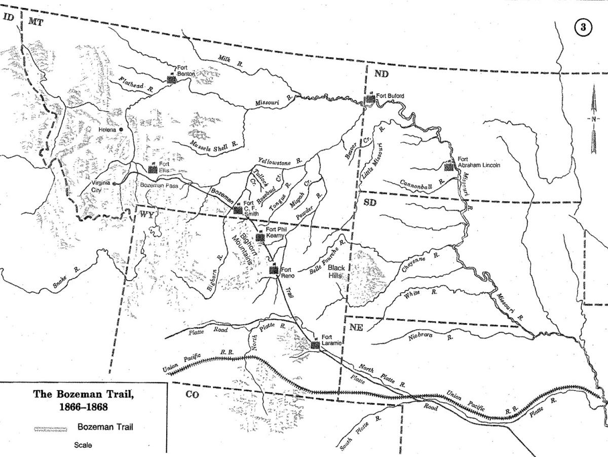
1. The Bozeman Trail. Right from the start, the Cloud Peak 500 embarks on a tour of the Old West by leaving the town of Sheridan on the Bozeman Trail. Better known at the time as the "Trail to Montana," the Bozeman Trail cut short travel from the Oregon Trail to the Montana gold mines by passing through the Powder River Basin. It followed established Native American trails used for centuries that skirted much of the surrounding mountains and deserts. Over the years, various native tribes vied for access to and control of the corridor.
In 1863, with native tribes threatening to kill anyone passing through, entrepreneur John Bozeman defied U.S. Army orders, slipped out of a protected town under cover of night, and led a group of nine men on the trail. For 21 days, they rode at night and hid during the day, eventually making it to Montana without incident. The next year, a train of 150 wagons plowed through with just one skirmish that left dead 3 newcomers and 13 natives. Thereafter, hostilities essentially ended for awhile. Bozeman Trail History.
Bozeman Trail, showing Fort Phil Kearney along the Bighorn Mountains.
(image from wyohistory.org)
2. Little Goose Creek. Turning off the Bozeman Trail, the Cloud Peak 500 winds along Little Goose Creek, where great chiefs Red Cloud and Crazy Horse frequently encamped. Eventually, settlers formed the nearby town of Big Horn, whose early inhabitants included English nobility with a taste for polo. Those Wyoming polo horses earned a reputation for exceptional strength and stamina, especially among European militaries in the late 1800's. Wyoming War Horses.
Moncreiffe Ranch near Big Horn, circa 1910, a center for selling Wyoming horses to European militaries. (image from wyohistory.org)
3. Red Grade Road. Now, we're climbing. This rough gravel road gains about 5,000 feet over the first 25 miles and then another 2,000 feet over the next 20 miles, with grades occasionally reaching 19%. As seen in the video below, the climb rewards with big views of the prairie below and 13,000 foot peaks above. That 45 mile climb knocks off some of the 40,000 feet of total elevation gain for the Cloud Peak 500 route, but there's still much more ahead. The video shown below is from dangerousroads.org, which calls Red Grade Road "one of the most treacherous roads in the State of Wyoming." Red Grade Road.
4. Medicine Wheel. At about 105 miles of the Cloud Peak 500, one can take a 7 mile detour to visit Medicine Wheel, a circular arrangement of limestone boulders, about 80 feet in diameter, with 28 rock spokes radiating from a central cairn. Natives lived in this area for about 7,000 years and believed that this high clearing at almost 10,000 feet harbored powerful spiritual forces. The alignment of the spokes with several significant celestial bodies suggest that the Medicine Wheel may have been used as an ancient astronomical observatory and calendar. Medicine Wheel.
Medicine Wheel in Big Horn National Forest.
(image from wyohistory.org)
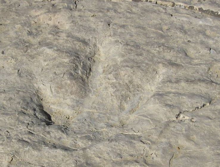
5. Red Gulch Dinosaur Tracks. Are you ready to see hundreds of three-toed foot prints of meat-eating dinosaurs from the Jurassic Period? The Cloud Peak 500 rolls right past the Red Gulch Dinosaur Track Site in BLM land south of Shell at about mile 150. These top-of-the-food-chain prints are preserved in solid rock all over the 40 acre sight. So, it's not just human history we're riding through. geowyo.com. BLM - Red Gulch Tracks.
One of hundreds of dinosaur tracks at the Red Gulch Dinosaur Track Site.
(image from geowyo.com)
6. Medicine Lodge Archaeological Site. At about mile 175, the Cloud Peak 500 rolls past the Medicine Lodge Archeological Site, a serene meadow along a creek that has been continuously occupied by people for over 10,000 years. A 750 foot long sandstone bluff showcases some of this ancient history with over 100 petroglyphs (carvings) and pictographs (paintings). This is a protected and developed historical site, with interpretive signs and a campground. I would love to spend an evening there. Medicine Lodge. Wyoming State Parks Medicine Lodge.
Petroglyphs at Medicine Lodge Archeological Site.
(image from wyohistory.org)
7. Ten Sleep. The story behind the name of this small village is told in the picture below. With that history, Ten Sleep would be a natural destination for a quiet evening on a long journey, such as the Cloud Peak 500. Sealing the deal for me is a local music festival of folk, bluegrass, swing, jazz and rock called NoWoodStock held on the second weekend of August. I'd love to arrive in Ten Sleep on the Saturday night of that festival. NoWoodStock.
There it is.
(image from bicycletouringtales.com)
NoWoodStock Music Festival in Ten Sleep during the second weekend of August.
(image from nowoodstock.com)
8. Butch Cassidy and the Hole-In-The-Wall. At about mile 293, the Cloud Peak 500 crosses the Middle Fork Powder River by a remote BLM campground. A little after this, a turn off leads back to the "Hole In The Wall," a legendary outlaw hideout from the Wild West accessible only by climbing a steep, loose, rocky wall. Within this natural hideout, many infamous outlaws and gangs co-existed from time to time, including Kid Curry, Black Jack Ketchum, Jesse James, Harry Longabaugh (aka the Sundance Kid), and Butch Cassidy's Wild Bunch Gang. In the winter of 1883, Butch Cassidy hunkered down in a log cabin and later developed a local reputation as a Robin Hood type outlaw. Hole In The Wall.
Access to the outlaw hideout "Hole In The Wall."
(BLM image from legendsofamerica.com)
9. Johnson County War. Here's more stuff of Wild Western lore, which occurred near the town of Kaycee at about mile 330 of the Cloud Peak 500. Starting in about 1889, large landholders grazing cattle on the open range resisted the growing presence of small homesteaders fencing land for their homes, crops, and small herds of cattle. The cattle barons eventually brought in 50 hired guns, resulting in numerous assaults, lawless killings, political intrigue all the way to the White House, and long term repercussions throughout Wyoming. The movies "Shane" and "Heaven's Gate" were based on this 4 year clash, which also inspired story lines for an entire genre of books and movies. Johnson County Cattle War.
The hired guns fighting for the large landholders pose for a picture before the "invasion."
(image from wyohistory.org)
10. Crazy Woman Canyon Road. This gravel road at about mile 404 is crazy cool, following a creek through a narrow, twisting canyon. Several legends offer explanations for the name of this canyon, but the story recounted here is common. Crazy Woman Canyon. In any event, I'll probably ride through this in the middle of the day.
Crazy Woman Canyon Road winding down Crazy Woman Canyon.
(image from onlyinyourstate.com)
11. Wagon Box Fight. In the summer of 1867, Chief Red Cloud vowed to kill every white person found on what he considered to be Native American land and carried out virtually continuous attacks along the Powder River Basin. With a force of over 1,000 warriors, he attacked a small group of 26 soldiers and 6 civilians cutting wood for nearby Fort Kearney. The soldiers used a small corral of 14 wagon boxes for cover and fired new, rapid-firing, breech-loaded rifles capable of 15-20 rounds per minute. For 6 hours, the fight waged without conclusion, until reinforcements arrived from the fort. The Native Americans' primary tactic of closing fast by horseback for close combat failed against that enhanced fire power from cover, which no attacker breached. The Wagon Box Fight forever changed tactics of both sides. Wagon Box Fight 1867.
The Wagon Box Fight 1867.
(image from wyohistory.org)
12. The Cattle Drive. An iconic image of the Old West is the resourceful, hardy cowboy driving a herd of Longhorns across the open prairie. Perhaps the most audacious cattle drive was in 1866 from Texas to the Montana Territory, which passed through the Powder River Basin along the Bozeman Trail. The Cloud Peak 500 rolls past the town of Story, Wyoming, named after Nelson Story, the man who spearheaded that historic cattle drive. That also sounds more than a little bit like the cattle drive in the Pulitzer Prize winning fictional novel "Lonesome Dove" by Larry McMurtry.
(image from TrueWestMagazine.com)
Many, many other stories, legends and myths emanate from this country. This is going to be fun.
It may also take a bit longer to ride than expected, as I will not be riding with my nose to the stem.