Different strokes for different folks,
And so on, and so on, and scooby dooby doo-bee,
Ooh, sha sha,
We got to live together.
Everyday People, Sly Stone (1968).
Like "boots on the ground" for the Army, there's nothing like "tires on the trail" for scouting back roads. And, in a recurring theme from me, once you're out there, you never know what you'll find.
 |
| This little gem is not on my USFS maps. |
While creating a five day bikepacking route for some out-of-state friends, I run into a snag. I really want to include roads through two certain areas that are separated by a significant ridge. But no map shows any way to make that connection, absent a relatively large mileage loop around. Even the satellite images on RideWithGPS do not show a clear way through.
One Low Standard Road comes close, abruptly stopping maybe a mile short of another Low Standard Road on the other side. Spurs like that are common in the Black Hills, with primitive roads built just to access areas to log. But this spur does not have that look. I wonder why that road just stops.
The other side of the ridge offers a greater number and variety of roads, with practically no spurs. A couple of maps even show a "spring" in a valley not far over that ridge. If I can cross that ridge somehow and make that connection, I may be able to access both desired areas and a water re-supply.
Time to get out there.
 |
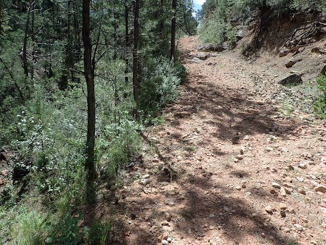
| Pretty tame start to this Low Standard Road. |
Although I've ridden throughout this area, I have not been on these particular Low Standard Roads. So, I slowly pull off a graveled Primary Road to look for signs. This looks like the right spot, but I'm not alone. In the shade by a small truck, a big pickup, and a trailer, a family of five saddles up horses. They don't look like they're just out for a ride. Not way out here.
As I step out of my Jeep, an older lady strides directly up to me. She's Susan, a rancher who lives nearby and leases USFS land here. Her daughter and family are mounting their horses to move a herd of cattle to a different pasture. She'll haul the trailer down the road to pick them up.
After a brief description of why I'm out there, I ask Susan if I can ask a few questions about the roads and water in this area. She readily agrees, I think mostly out of her general willingness to help and maybe a little out of curiosity.
Spreading out a USFS map on the hood of my Jeep, I ask her whether 1) this area is USFS land, not private; 2) this Low Standard Road goes through to this marked spring, even though the map says it doesn't; and 3) this spring has fresh water. Yes, Susan replies, to all of it. She says they run cattle through there, but stopped using that old road over the years as it deteriorated and instead access the spring from the other side. But she thinks I can get still get through on a mountain bike. She adds that her family installed a pipe to directly access that spring and that fresh spring water flows continuously all year.
Well, alright! How's that for local intel! Thanks, Susan!
 |
| Another part of the "not-on-a-map" connector. |
Of course, I hop on my bike to check it out. The Low Standard Road flows smoothly along a mellow meadow for the first 2-3 miles, before dissipating into solid knee-high grass. Looking at the land and my maps, I reckon the "road" must generally go this way, if it's going through. So, I hack my way through the grass for a bit before spotting the makings of a road ahead.
This must be the way, but now it's rough. Rocky. Loose. Sometimes steep. But it's definitely an old road and it's heading in the right direction. And it's rideable, at least on my unloaded mountain bike.
Sure enough, after about a mile of that rough stuff up and over a ridge, I emerge onto an actual Low Standard Road and drop into another meadow. There it is. A large water tank fed by a pipe with steadily flowing water. Cool beans.
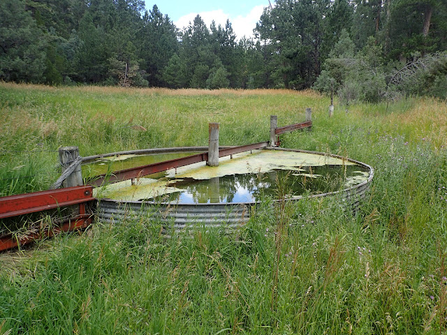 |
| Although the water in the tank looks a bit saucy, there's a pipe feeding fresh spring water into it. |
What a day! I find a really nifty, unmapped connector that very few people likely know about, let alone ride, and that pops out to a reliable source of fresh spring water. There's even ample space to disperse camp along the meadow, if desired. This connector solves some big routing issues for me and will be a nice add to the trip.
I lightly spin back to my Jeep to find Susan and her family picking up their shuttle truck. She introduces me to everyone and asks what I think about the road and water. And they all want to hear more about the bikepacking trip. They live right out here and are excited to see others enjoying this special place.
I just want to hear what it's like to be a grade schooler herding cattle by horseback through the forest. That sounds like a grand adventure to me. Susan's grandson shrugs. All in a day's work.
As usual, the best connection made today is with the people met along the way.
Everyday People, Sly & The Family Stone (1968).
Love the connector story. These experiences make it all worth it
ReplyDelete