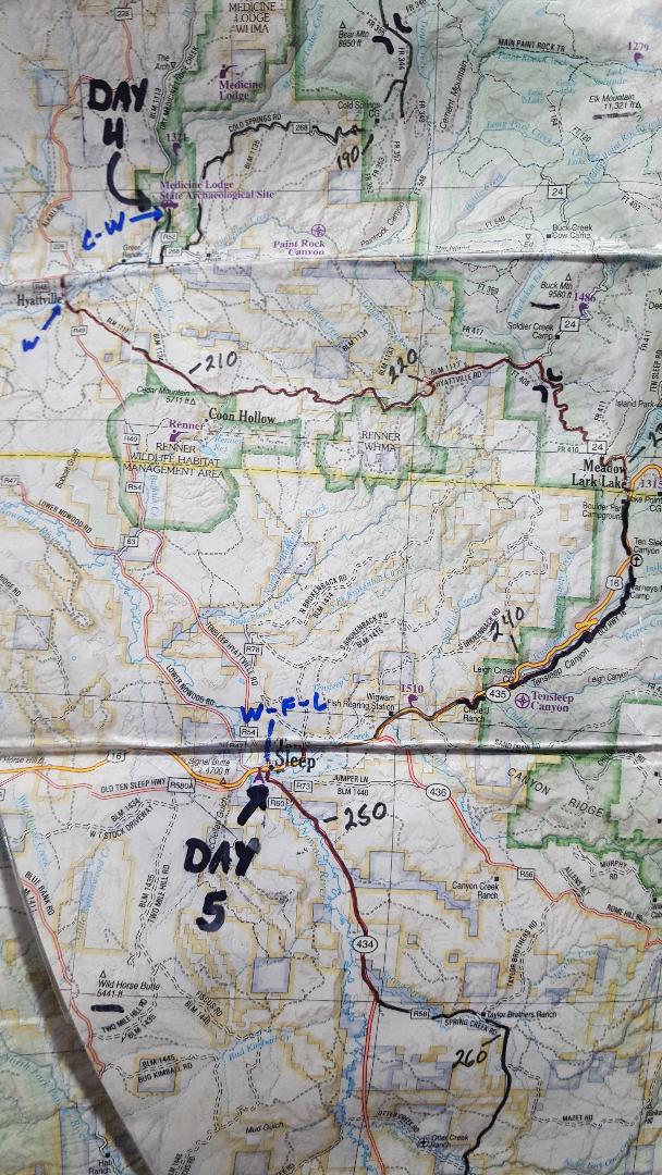
The Cloud Peak 500 is a 500 mile remote road loop in and around the Big Horn Mountains of Wyoming. This post is part of a series that describes some of each day's logistics involved when we rode the route on bicycles loaded for a 7-8 day self-supported tour in early August 2020. It also includes a screen shot and link to a digital map on ridewithgps.com, which I created after the trip to show our ride for each separate day. Finally, it adds a photo gallery. This post covers Miles 201-251 of the route, which was our Day 5. Go to Miles 0-52 for Logistics for Day 1, go to Miles 52-104 for Logistics for Day 2, and go to Miles 104-151 for Logistics for Day 3, go Miles 151-201 to for Logistics for Day 4.
Much like yesterday, this day looks relatively short on paper at about 50 miles, but it aggressively climbs almost 5,000 feet on soft roads with virtually no shade until near the top. Indeed, one stretch in the middle gains 3,500 feet in 11 miles. Once the climb is over, however, the final 20 miles are downhill, including about 8 miles of memorable gravel flying down Ten Sleep Canyon.

We start Day 5 from the Medicine Lodge State Archaeological Site at Mile 201 at an elevation of about 4,800 feet. The first 5 miles follow paved roads sloping gently down to the hamlet of Hyattville. Continuing south of Hyattville, the route follows a mellow Road 49 for a little more than a mile, then forks left onto Hyattville Road (BLM 1117) for the next 19 miles.
Consider Hyattville Road as one, long climb on a dusty, loose, shadeless primitive road that is more than occasionally steep. Oh, there are a couple of short breaks in gradient along the way and some trees start to appear near the top. But this is one, long, demanding, exposed climb. No shade. No water. Not unlike yesterday.
Back at the fork onto Hyattville Road, it starts relatively mellow, rolling along for about 6 miles along a valley. But then it goes up aggressively and relentlessly for 11 miles. This is the heart of the climb.
The road surface is still primarily soft dirt, like yesterday's Red Gulch Road, but with few of the rutted, hard packed stretches. Apparently this road must not experience as much vehicle traffic. It was bone dry when we rode it, but I cannot imagine that it is rideable wet.
Hyattville Road passes by the Renner Wildlife Management Area, which is accessible by several primitive roads. None of these other roads present a navigational issue, however, as they are even more primitive and Hyattville Road is generally well marked. Just stay on the main road that keeps going up.
For the 19 miles of Hyattville Road expect no shade and no water. Maps show a small reservoir within the Renner Wildlife Management Area, but it is a couple of miles off route. Satellite images also show some trees, but those are near the top. Expect another long, hot, dusty climb.
With every mile, the increased elevation delivers bigger and bigger views to the west. The short descent cut in the hillside between miles 12 and 13 is still visible almost 10 miles later, if one takes a break to look back.
Eventually, Hyattville Road enters the Big Horn National Forest and T-bones into USFS 24, a more developed and maintained Forest Service road that carries significantly more recreational traffic. USFS 24 climbs more gradually and rolls a bit for about 4 miles to top out at a high mountain pass, where several other primitive USFS roads and trails intersect. The long climb is finally over.
Now, it's a solid 20 mile downhill all the way to Ten Sleep, starting with a couple of miles of gravel, turning onto paved U.S. Highway 16 for a couple of more miles and then onto gravel road USFS 435, also known as "Old Highway 16," for about 8 miles. Old 16 is fast, fast, fast, with occasional washboards and regular vehicle traffic. Stop frequently to enjoy the views of Big Sleep Canyon, both up and down. Keep an eye out for rock climbers scaling the big walls.
The route merges back onto U.S. Highway 16 for the final 8 mile roll into Ten Sleep. Surprisingly, we found only one "motel" in Ten Sleep, but no one was there and it looked barely habitable. A sign said "vacancy" and another gave a number to call. The person answering the phone asked for $135/night. Nope. Not from us. A tent on the over cooked ground would be better.
On the west side of town is the "Ten Sleep RV Park," which offers RV sites, tent sites, cabins and even a "horse camp." The cabins were small and sparse, but air-conditioned and priced at $50/night. Showers and a laundromat were also available. The folks there were friendly, helpful and accommodating. We would stay there again, whether traveling by bike or motorized vehicle.
We showered, washed clothes, attended to bikes, and cranked up the AC in the cabin. We then ate dinner at the "Sleepy Coyote," a bar/restaurant on the main street. The decor was trendy, but my burger was barely cooked, fries were cold, soda had virtually no carbonation, and the service was indifferent to the point of apathetic. Yes, we did shower first and even change into civilian clothes. I'd eat a three day old gas station burrito before returning there.
Overall, the route from the Archaeological Site to Ten Sleep is about 50 miles and 4,900 feet of elevation gain. For the Cloud Peak 500 route so far, that's about 251 miles/25,800 feet of elevation gain total.
Paul Brasby Photo Album.


Craig Groseth Photo Album.


No comments:
Post a Comment